
Hillslope Springs
Stories Shared Between Good Earth and Blood Run

It seems appropriate to think and talk about natural springs on the Land when there’s springtime in the Air! And it also seems important to stitch together the stories that are shared between Good Earth State Park and Blood Run National Historic Landmark (NHL). Even though Good Earth is on the west side of the Big Sioux River in South Dakota and Blood Run is on the east side in Iowa, their natural and human histories are tied closely together. Those shared stories are much more important and interesting than the artificial political and governmental boundary lines that divide and separate them in more ways than one.
Natural springs have always had a central place in human history. The spring at Delphi in ancient Greece hosted the woman who was the prophesying Oracle. During Roman times springs like those at Bath in England were used for both health and leisure. That “spa” tradition eventually extended into the United States with President Franklin Roosevelt conducting national business from the “Little White House” in Warm Springs, Georgia. And of course, everyone has heard about the hot springs in Yellowstone National Park. While these AI-generated factoids may be mildly interesting, it’s much more important to recognize that we’ve got springs along the Big Sioux River.
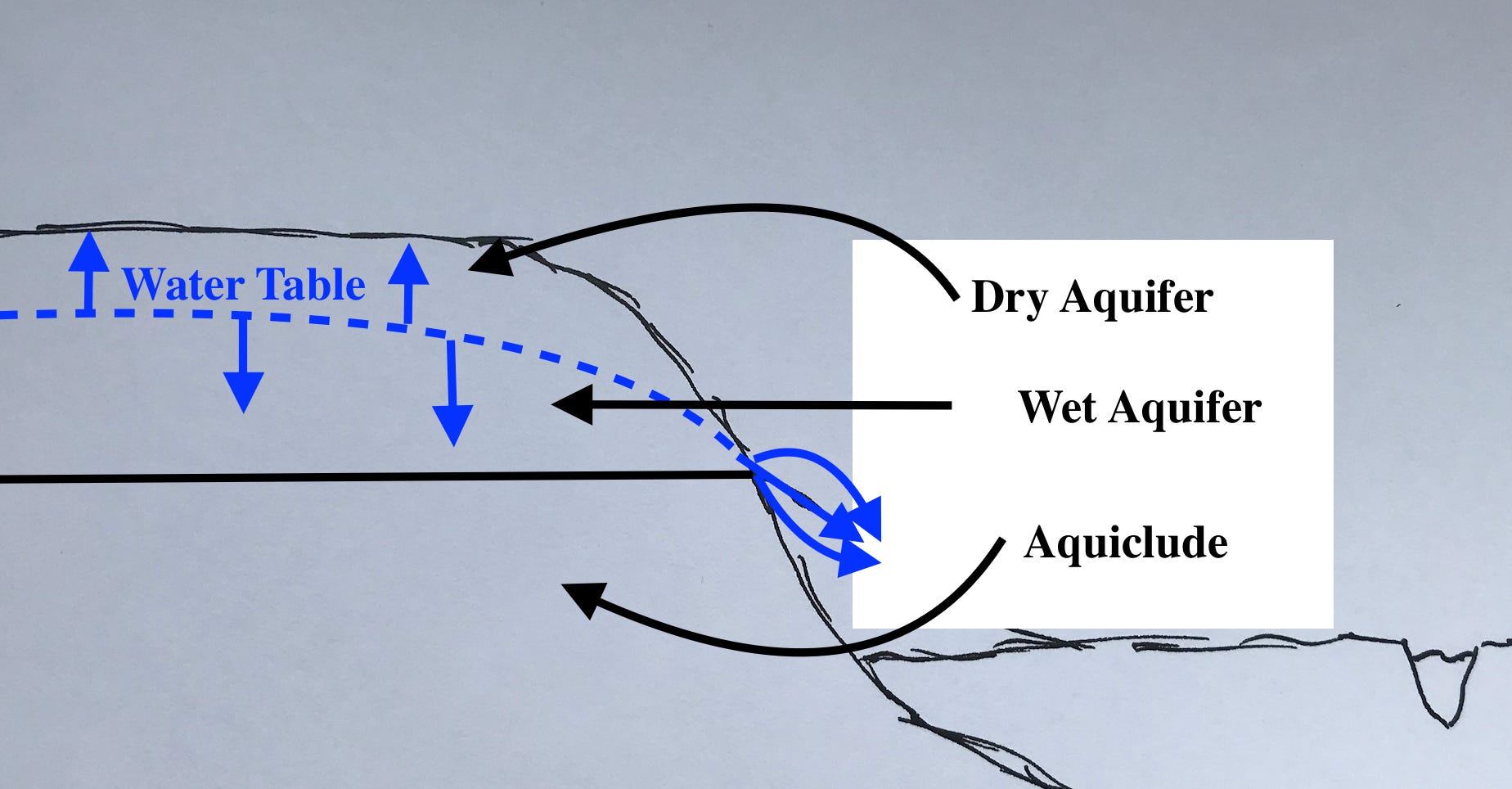
Figure 1----Idealized cross section showing the main components of hillslope springs.
The generalized components of a hillslope spring are shown in Figure 1 which is “repurposed” from a post last year. That essay reviewed the co-location of archaeological sites, plant communities, geologic materials, and topographic positions in Good Earth. Putting all that information into one image got pretty complicated, so Figure 1 is simplified to emphasize the water and earth aspects. There are two main types of geologic material: an aquifer with high porosity and permeability that will store water and allow it to flow; and an aquiclude with low porosity and permeability that acts as a barrier to water movement.
In addition, there are two “layers” within the aquifer. The upper relatively dry part has minimal stored water and the lower wet part is saturated with water. They are separated by the water table which is essentially the top of the saturated aquifer. The water table moves up and down mainly in response to precipitation: during wet times it shifts upwards and during droughts it shifts downwards. A hillslope spring is located where the saturated wet aquifer encounters the edge of the hill (blue arrows, Figure 1). When the water table shifts upward the ground water will seep out over a larger part of the hill. When the water table shifts downward, the front of the wet aquifer may back away from the edge of the hill and the spring will dry up. Obviously, this whole discussion is over-simplified, but it does provide a basic way to visualize the location, growth, or decline of hillslope springs.
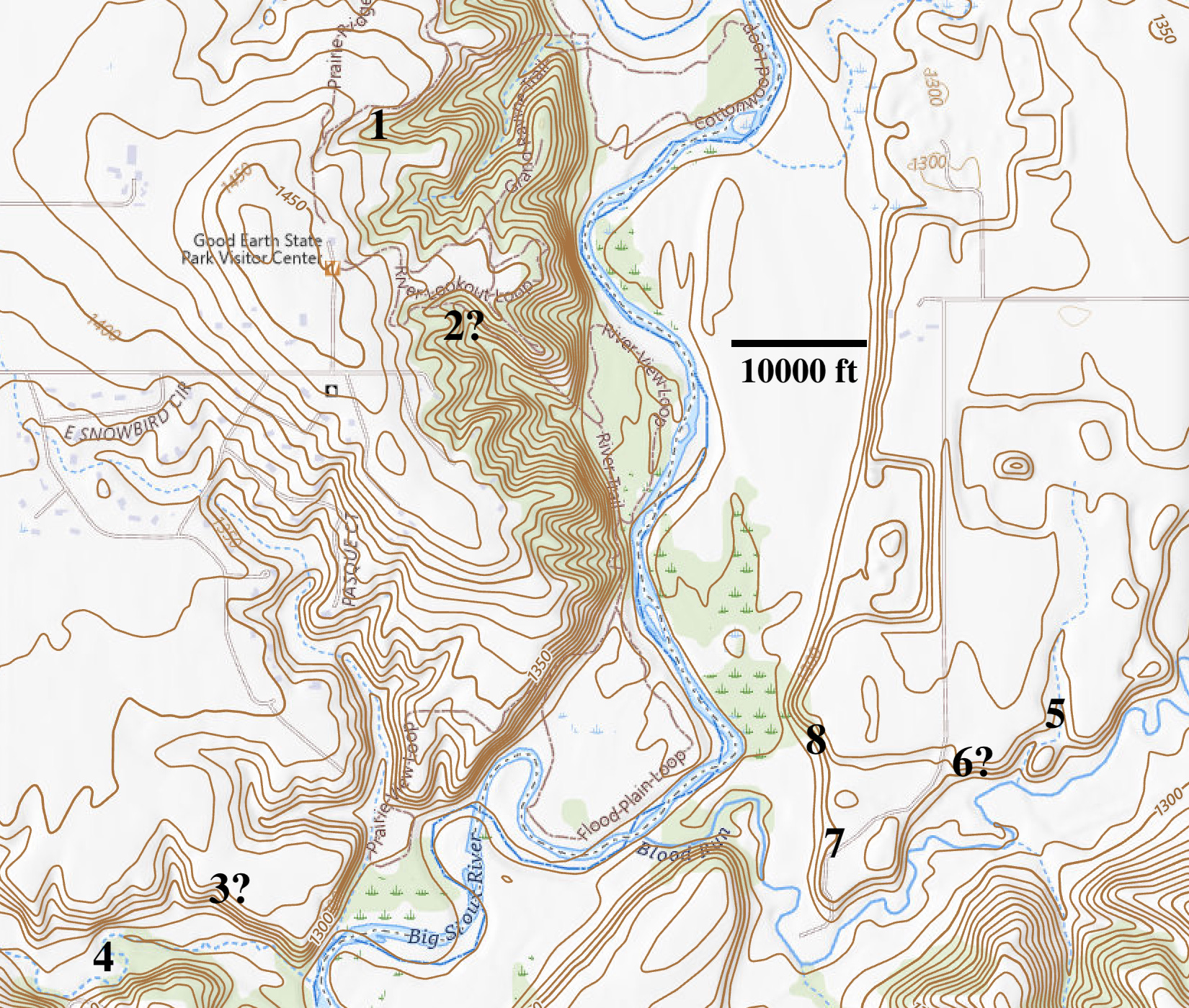
Figure 2----Topographic map of the Big Sioux River Valley with Good Earth State Park on the west side and Blood Run NHL on the east side. Natural springs are marked by numbers 1 through 8.
On the west, Good Earth is located in relatively steep and hilly topography as shown by numerous close-spaced elevation contours (Figure 2). Springs at locations 1 and 2 are at around 1400 ft, about 100 ft higher than the springs at location 3 and 4. However, the geologic map of Lincoln County, SD, shows both areas in a stagnation moraine complex and glacial till is the parent material for soils mapped throughout the west side.
In contrast, the east side has widely spaced and fewer contours (Figure 2) that show Blood Run is flat with very little local relief. The springs 5 through 8 are all at about the same elevation (1280-1300 ft) and are distributed along hillslopes on the margins of a flat area mined for gravel. Regional geologic mapping suggests that the layer of gravel and sand deposited by glacial meltwater overlies clay-rich glacial till similar to that found at Good Earth. However, the till on the east side of the river is probably older than the tops of the till hills on the west side.
The springs at locations 1 and 3 have been described in previous posts. I think that I remember seeing a spring at 2 that was similar to the one at location 1. Location 4 marks Spring Creek, but I don’t know anything about why it’s named that! The spring at location 5 was documented in the biology report for Blood Run; the one at 6 is a possible similar setting. I’ve speculated that there may be a possible spring at 7 and location 8 is the Sacred Spring that we’ve discussed many times.
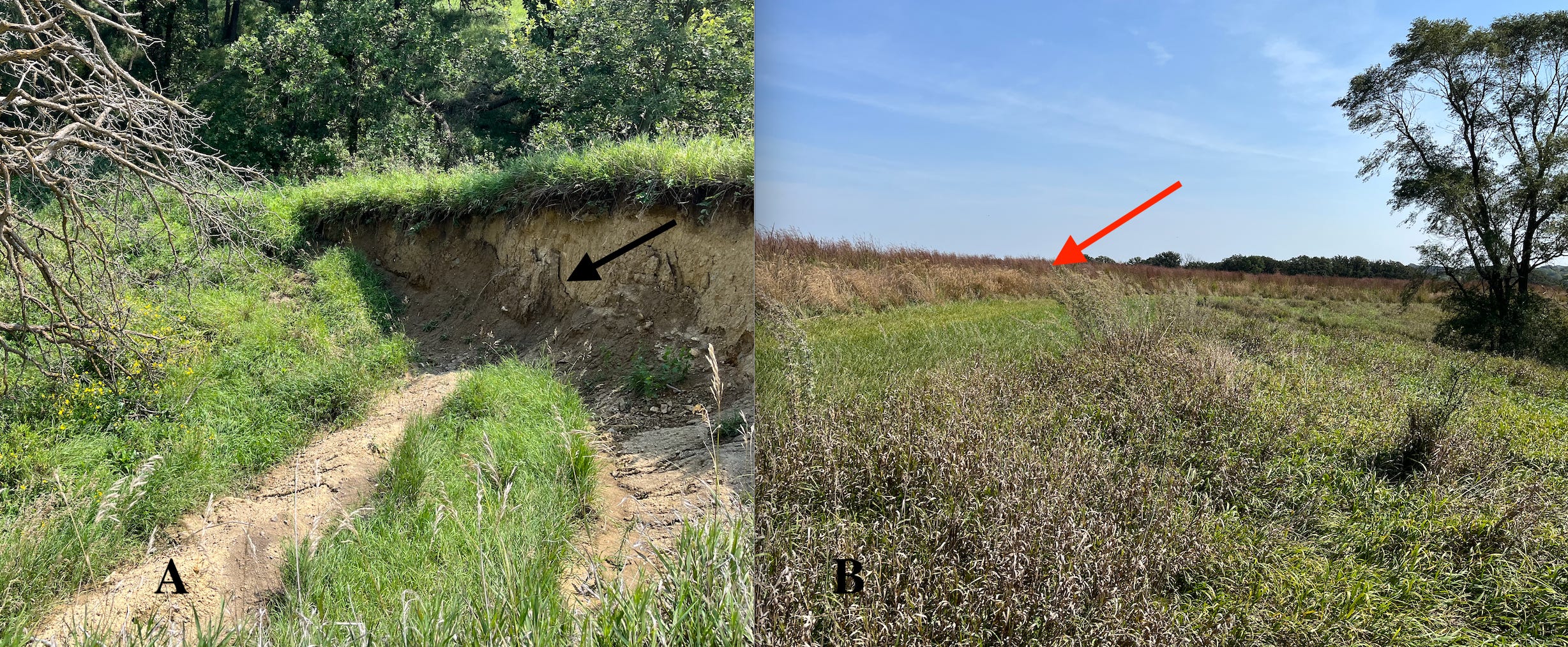
Figure 3----Hillslope springs in glacial till at Good Earth. A) Spring associated with a landslide at location 1 (Figure 2) in the northern part of the park. The black arrow points to the spring. B) Possible spring near an archaeological site at location 3 in the southern part of the park. The red arrow points to the archaeological site.
Glacial till is a poorly sorted clay with local small sand and gravel bodies and occasional boulders mixed in. It’s generally a low porosity/low permeability aquiclude that limits the movement of ground water. But, if it’s badly fractured and weathered it may also act as an aquifer; the relatively unfractured till below would act as an aquiclude. The resulting arrangement would look like the idealized geometry for springs shown in Figure 1.
Groundwater movement may also trigger landslides so that springs are often associated with the resulting slump blocks (Figure 3-A). In addition, distinctive plants are usually found in and around springs. For example, a tree is situated at the head of a gully (Figure 3-B) with large boulders farther downslope that probably reflect glacial till. The possible spring at this location 3 (Figure 2) would be in fractured, weathered till as well as the spring and landslide at location 1. However, now we’ll tour some springs on the east side of the river in Blood Run that seem to have somewhat different aquifer and aquiclude materials.
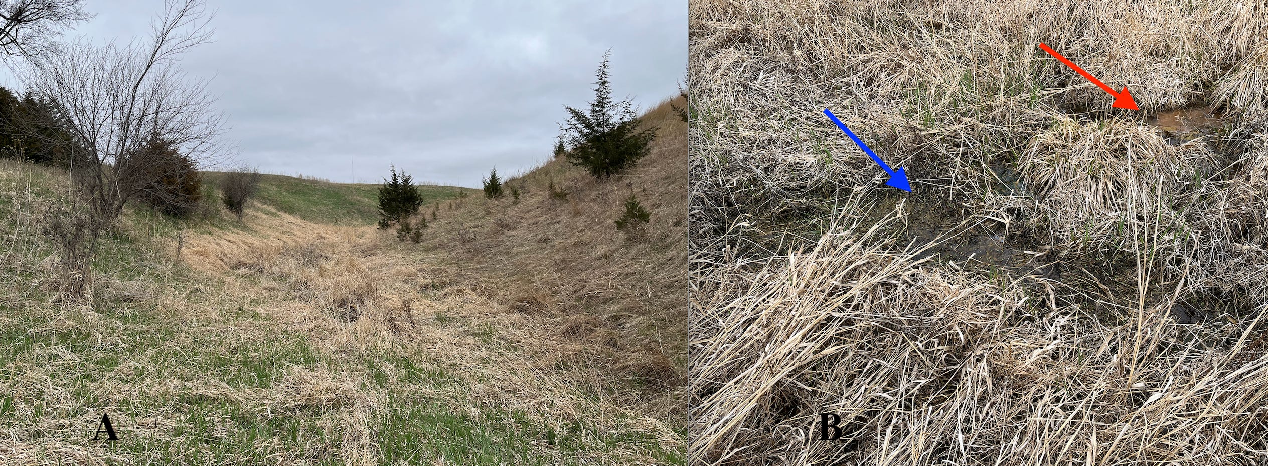
Figure 4---- Topography and vegetation in the seepage swale in Blood Run NHL. A) Lower part of the seepage swale. B) Standing water in the bottom of the gully.
The recent biological survey of Blood Run described a complex of plant communities on the eastern side of the property that document a previously unrecognized spring (Location 5, Figure 2). That seepage swale has wetland plants confined to a distinctive topographic gulley. The lower part of the gulley has high, steep sides and a narrow strip of wetland vegetation along the bottom (Figure 4-A). In the floor of the gully, puddles of water mark the active part of the spring and some of those puddles are red due to iron oxide and/or algae (Figure 4-B). It’s been suggested that red water like this may have provided the basis for naming the stream Blood Run.
This active hillside spring is probably the result of an aquifer of sand and gravel perched on top of a clay till that’s acting as an aquiclude. The aquifer layer is associated with the flat upland surface above the termination of the upper part of the gully. However, there could be some complications if the clay aquiclude is fractured and weathered so that part of it acts as an aquifer in tandem with the overlying sand and gravel.
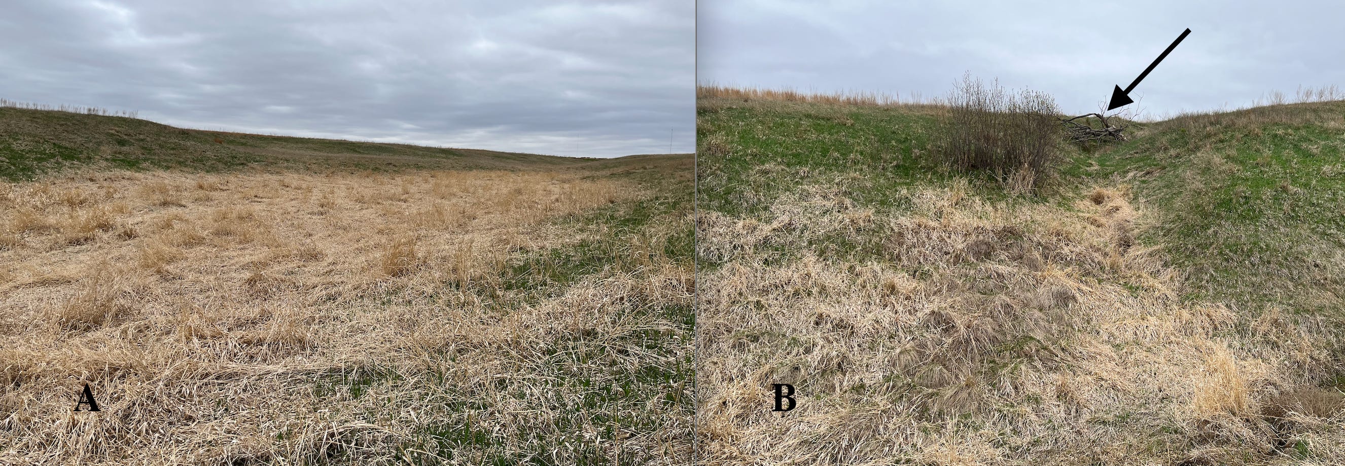
Figure 5----Views of the upper part of the seepage swale in Blood Run NHL. A) Long brown wetland grass contrasting with short green grass higher on the slope. B) Steeper side gulley with the remains of a tree near the head of the gulley.
The upper part of the seepage swale opens out into a wide flat area where brown wetland plants are clearly distinguished from the green vegetation higher on the sides of the gulley (Figure 5-A). There are no conspicuous water puddles, so the groundwater is probably more passively “seeping” rather than actively flowing out on to the surface. One of the steeper side gulleys has the “bones” of a tree preserved at the head of the gulley (Figure 5-B) in a position similar to that observed at Good Earth (Figure 3-B).
This location is farther upslope and closer to the sand and gravel aquifer layer under the flat upland surface. The less active seep in this area may indicate that the underlying fractured and weathered till is also acting as an aquifer. A similar somewhat complicated story possibly applies at location 6 (figure 2). This gully on the east margin of the abandoned gravel pit may have once hosted a spring in a seepage swale, but the gravel operation modified the water table configuration and the spring dried up.
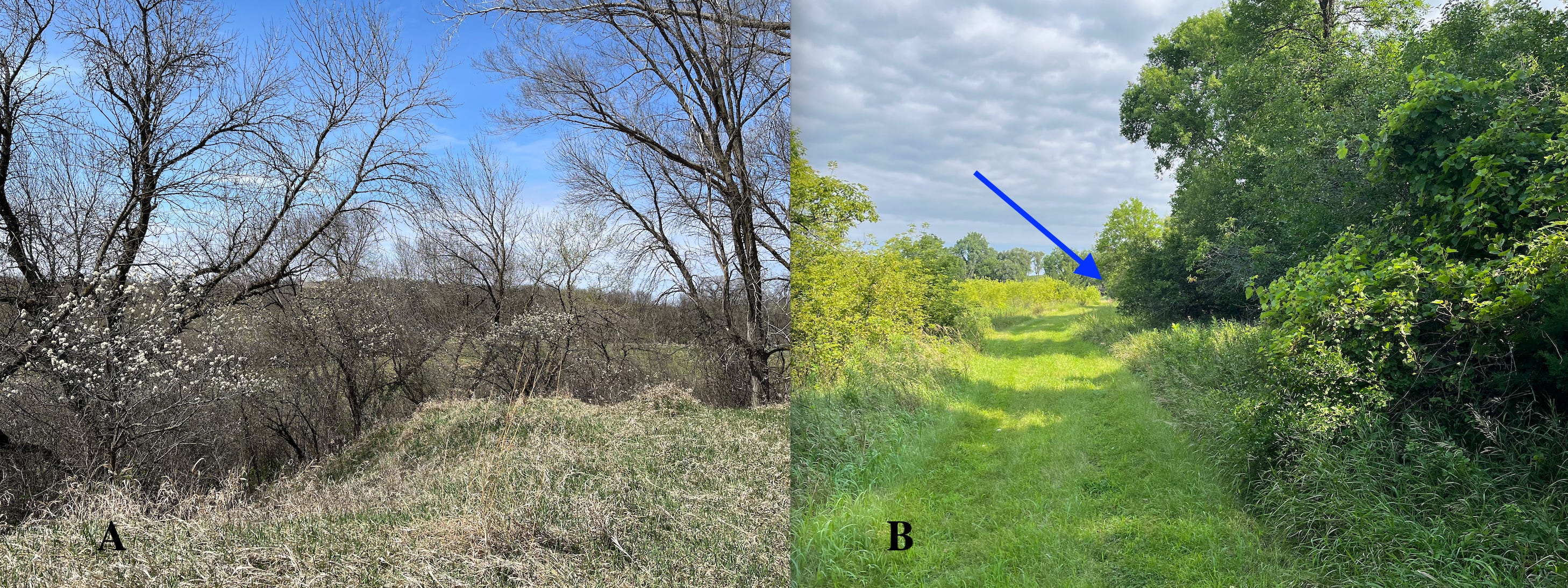
Figure 6----Probable spring location in the abandoned gravel pit in Blood Run NHL. A) Seasonal plum blossoms in the upper part of the gully at the floor of the pit. B) High summer vegetation at the lower end of the gully, including wild plums, choke cherries, and wild grapes.
There’s a spring on the west side of the older part of the abandoned gravel pit (location 7, Figure 2). A large cottonwood tree is at the head of a gully filled with small trees and shrubs including wild plums (Figure 6-A) as well as choke cherries and wild grapes (Figure 6-B).
When there’s plenty of rain, the pit floor just east and on trend with the gulley will have water puddles. When there’s less rain the puddles dry up. This is all probably in response to the water table shifting up and down. But the overlying gravel aquifer has been removed, so the spring must be in the lower layer of fractured and weathered clay till!
That complicated hydrologic setup is probably very similar to the conditions at the Sacred Spring that lies just to the north at the end of the path along the base of the hillslope (blue arrow, Figure 6-B). That’s one of the most iconic features of Blood Run NHL (location 8, Figure 2) and it’s recently had some renovation. But, we’ll come back to the Sacred Spring in the next post to look at the implications of the complicated hydrology.
Happy Mothers’ Day!
Another fascinating perspective on this place. The deep mapping approach is quite compelling. Do you know Greg Seitz of 360StCroix? He's working on a book deep mapping the St. Croix River (between Wisconsin and Minnesota). This approach is deep and immersive. Always enjoy adding a new layer of understanding from your work.