


Preparation
Describing the Place

Once upon a time, I had a blog. It focused on the multi-generational family Farm where we then lived and it described the “natural history and human history along a tall grass prairie stream”. It started out slow, but picked up frequency between 2019 and 2021 as the pandemic reduced a lot of other activities. We’ve now moved away from the Farm and I’m trying to get back into a more structured writing routine by posting these “newsletters”.
The plan is to expand the focus from the area of the Farm to the surrounding multi-county region in southwestern Minnesota, northwestern Iowa, and eastern South Dakota. These little essays will continue to describe and discuss natural and human history, similar to the topics addressed in my original blog. Here’s a link to the old blog that will give you a flavor of what I’m most comfortable writing about:
https://lonetreefarm.blog/
This current post provides a description of the new, expanded Place. We’ll start with the earth science aspects because that’s easiest for me as a retired geologist. But the idea is to expand out into the life sciences and social sciences because that’s where I’m learning new things that I’d like to share with you.
We begin with the Bones of the Land….the rocks. Almost all of the area has a “basement” of resistant, red crystalline bedrock called the Sioux Quartzite. It’s really old (billions of years) and it has younger (millions of years), softer sedimentary rocks spread in relatively thin layers around the flanks of the buried quartzite “ridge”. In places the top of the red quartzite ridge sticks up above the ground surface to be exposed as outcrops.
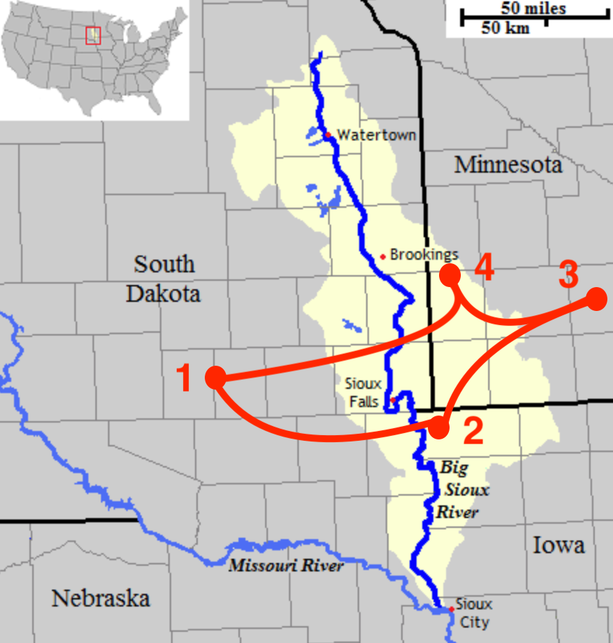
Figure 1----The general area where bedrock is exposed along the crest of the buried ridge.
Back in the early 1950s, a PhD student from Columbia University mapped outcrops of Sioux Quartzite distributed through the area that is my Place of focus. Figure 1 shows a red outline of where there are widely dispersed exposures and where the bedrock is fairly close to the surface. The western-most exposures (1) are near Mitchell, SD, and the last exposure to the south is at Gitchie Manitou State Preserve (2) in the extreme northwest corner of Iowa. Outcrop areas at the Jeffers Petroglyphs (3) and the Pipestone National Monument (4) in Minnesota are sites that have cultural significance for Native Americans and are the last exposures of Sioux Quartzite to the east and north, respectively.
Glacial sediments and the soils developed on them form the Flesh of the Land. These much younger (thousands of years) glacial deposits are hundreds of feet thick and continuously cover the entire area. Multiple ice sheets moved over this Place, but the last one left a series of end moraines that outline a distinctive landform known as the Prairie Coteau. It is a canoe-shaped highland that is generally elongate north-south in much the same way as buried ridge of red quartzite is elongate east-west. The Big Sioux River flows right down the spine of the Coteau and its watershed reflects the topography built by the glaciers.

Figure 2----The Big Sioux Watershed shown in yellow and the Place of focus shown in red.
The Big Sioux River is the Blood of the Land because “water is life”. The river is polluted and plagued by politics, but it still sustains us in much the same way that it always has since its beginnings as a meltwater stream along the margins of the last ice sheet. Although the river marks the border between South Dakota and Iowa and although the outline of the watershed bulges out to the east into Minnesota and Iowa, it is primarily a South Dakota landmark. The main stem shown in blue in Figure 2 generally trends north-south corresponding with the middle of the Coteau. It crosses the buried ridge of red quartzite near Sioux Falls at the approximate center of the Place where these essays will focus.
Rock as bones, soil as flesh, and water as blood are all elements of the Gaia Paradigm which says that the planet and organisms interact in a self-regulating way that sustains life. The planet is alive with the wind as breath, plants as skin, and animals as the nervous system. This all sounds like a “New Age” “blast from the past”, but it also goes back to the ideas of Teilhard de Chardin. He visualized a living planet evolving toward an “Omega Point” that is basically an end-of-time religious concept. You can find out more than you want to know about these things in Wikipedia, but they pertain to the total planet and our specific Place gets lost in all the theoretical speculation.
It's probably more appropriate to use the Three Sisters as a metaphor in this specific Place. Native Americans recognize corn, beans, and squash as the Three Sisters that work together to sustain life. The corn stalks are like the bones/rocks that provide the support for the bean vines to climb. The beans are like the flesh/soil on the corn stalks. Squash vines spread out along the ground like blood vessels/water channels. The buried quartzite ridge holds up the blanket of glacial soil and the river runs through it all.
It's important to acknowledge sources of information. In these posts I’ll use an informal, abbreviated citations. For example, the map of red quartzite outcrops is from Baldwin (1951) and the map of the Big Sioux Watershed is from Wikipedia. If you want to check out the source to follow up on more information, please let me know. I’ll send you a more formal, full reference to the literature citation.
The next post will clarify the Location by Naming the Place. However, the conventional geographic crutches like states and counties will be enhanced with older names rooted in the language of the land. If you’re wondering what that language might be, please subscribe and follow the trail to the Place that I’m calling “The Land at the Edge of the Sky”.