


Understanding the Creek's Gifts
The need for Outside Help

The Creek has given us a flood of information, but we aren’t exactly certain about what it all means. The need for outside help began to become more urgent after our grandchildren found the Bijou bifaces/knives on the Farm in 2016 and 2018. A professional archaeologist did identify the pottery and blades for us as described in the last post. Since the pottery and many of the arrowheads were found in a fairly limited area, we began to think that we should have some fieldwork done. In addition, some conspicuous circles in the grass located in that same area got us to thinking about the possibilities of features like storage pits and the footprints of dwellings.
However, before bringing in a professional archaeologist we looked for help from someone who was familiar with Native American traditions. We wanted any further work to be done in a respectful way and sought input from a Tribal Historic Preservation Officer (THPO). In a phone conversation I asked what we should do before inviting an archaeologist to work on the site. He told me to formally ask the Land and the Creek directly about it. That made good sense because the Creek seemed to be sharing information. So, I sat out in the middle of the site on a beautiful fall afternoon and listened to the Land. The message wasn’t loud or dramatic, but it was clear: the Creek had more knowledge to share.

Figure 1----Circular vegetation anomalies at site 21RK82. A) View from a 2016 high-resolution aerial photo. B) Expression of the largest circle on the ground. The metal detector at the right side is used for scale and shows the general size of the feature.
I first noticed circles in the grass (aka “circular vegetation anomalies” because that sounds more “scientific”!) in about 2017. There may have been some before that time, but I never saw them and they’ve been only sporadically visible since then. Although they’ve got clear expression on high-resolution aerial photos available from the county (Figure 1-A), it’s the photos from 2016 that show them best. At the right time of year with favorable grazing and rainfall histories, the grass circles are also clearly visible on the ground (Figure 1-B). There are other locations on the Farm that have grass circles and I’ve seen them on satellite images in other parts of Minnesota and in Iowa, South Dakota and Nebraska. While we may not know what causes them, it is clear that on Lone Tree Farm they are located where artifacts have been found.

Figure 2----Survey of soil magnetic properties. A) Measurements are made at specific points within a grid. B) Location of the gridded area relative to the Creek channel and the sand bars where artifacts have been collected. Images are taken from Messerole (2018).
There are specialized geophysical tools that can be used to evaluate possible archaeological features without digging into them. One of those instruments measures the magnetic properties of soil at a large number of closely-space points and then integrates those numbers into images. Actually, it compares the measurements between points to calculate a gradient, so it’s called a “gradiometer”. The white tube in Figure 1-A is the instrument and the archaeologist walks along the tape in rubber boots because any metal in her clothing will influence the measurements. The location of the gridded area where the measurements were taken is shown in Figure 1-B. The red arrows point to sand bars where artifacts have been collected. The grass circles being evaluated are located near the two white triangles at the north end of the grid closest to the channel. That stream bank is actively eroding and that’s probably why the artifacts are showing up of sand bars. But, it also raises a concern about the destruction of the grass circles.

Figure 3----Map of soil magnetic properties with possible archaeological features shown in red. Image from Messerole (2018).
A lot of numbers are produced from the gridded survey so it naturally takes a computer to handle all that data. With the right software, images that integrate and summarize the data can be generated and used to interpret possible archaeological features. For example, the open red triangles may be ancient fire hearths. In contrast, the solid red triangles are probably modern pieces of metal. We don’t know about the significance of the features shown by dashed red lines through the center of the map. However, the upper right area has a number of details that relate directly to the grass circles.
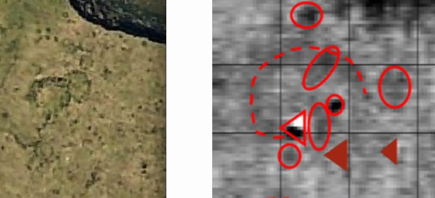
Figure 4----Comparing the grass circles visible in a 2016 air photo (A) with the patterns in soil magnetic measurements (B).
There’s a complex of large and small overlapping circles in the vegetation documented by a high-resolution air photo (Figure 4-A). Note the threatening stream channel at the top of the photo. The largest circle is in approximately the same location as the magnitic signature outlined by the dashed red line in Figure 4-B. This has been interpreted (Messerole, 2018) to be a possible dwelling outline with a fire hearth shown by the open red triangle. The smaller red circles may mark storage pits and the red ovals may be interments/burials. Figure 4-B is an enlargement of the upper right part of Figure 3 and has been rotated to match the compass orientation of Figure 4-A, specifically north is toward the top.
The interpretation of a dwelling recorded in the magnetic data has been supported by a former Iowa StateArchaeologist (William Green, personal communication, April 15, 2021). He has been looking for mounds flattened by farming along the Mississippi River in eastern Iowa and confirms that the circular pattern in Figure 4-B looks more like a dwelling outline than a mound that has been destroyed. The oval-shaped items that may mark burials are also seen on the left side of Figure 3. We subsequently had a survey done by cadaver dogs that are specially trained to identify ancient human remains and they give “alerts” in this general area. That re-enforced the decision to do non-invasive investigations rather than just excavating without regard for human burials.
In addition to the report that she prepared for us, in 2020 Megan Stroh Messorole wrote a paper that was published in The Minnesota Archaeologist which is the journal of the Minnesota Archaeological Society. She also submitted the documentation required to have the formal site number (21RK81) designated by the state of Minnesota. Megan currently works for the US Department of Agriculture’s Natural Resources Conservation Service as a Cultural Resources Specialist and State Archaeologist for Iowa.
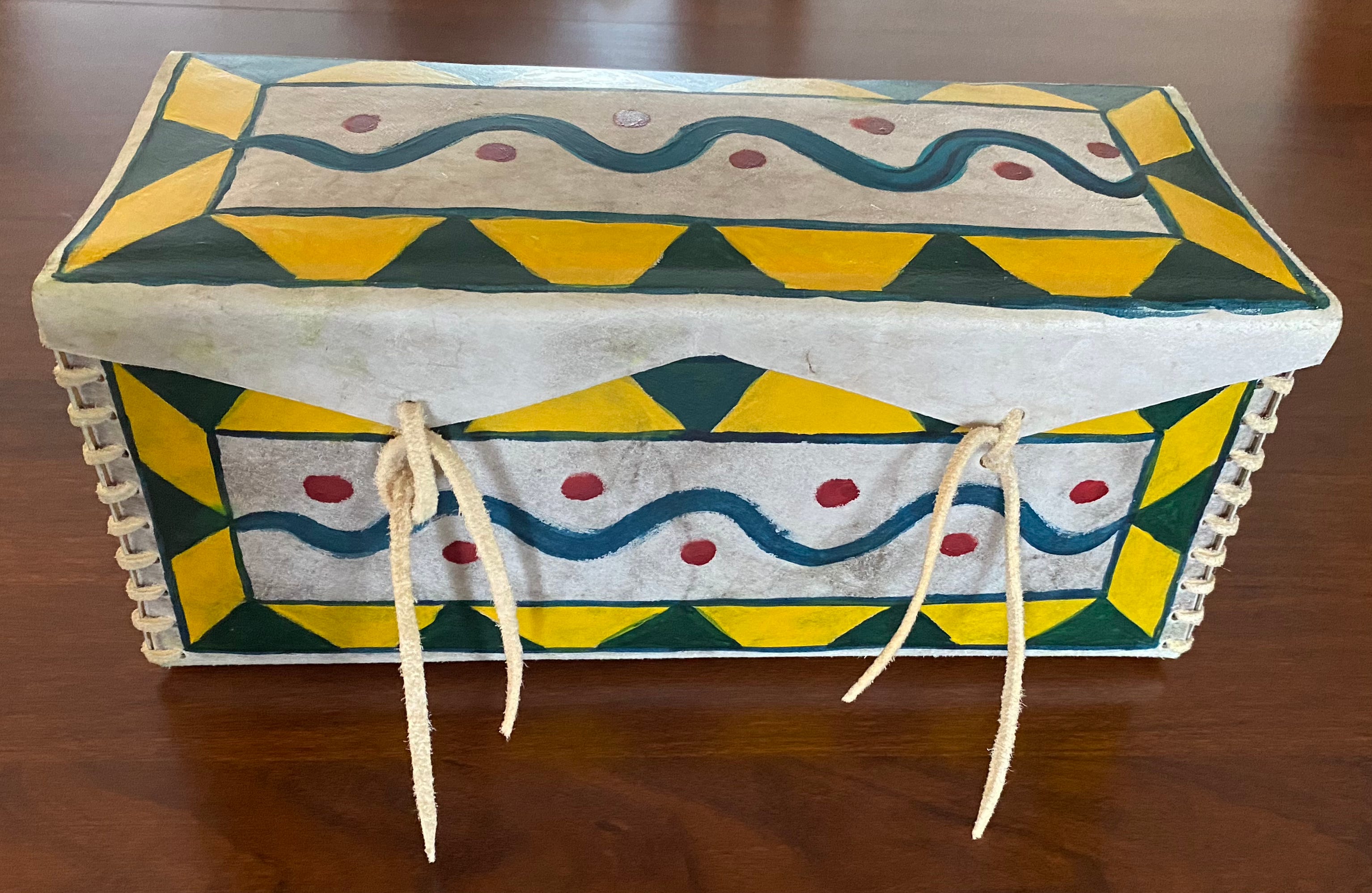
Figure 5----Parfleche box created by Avery Jones in 2022.
Before we left the Farm in 2022, my friend Avery and his family visited as I described in an earlier post. He’s a keeper of traditional Dakota knowledge, a linguist and scholar, an artist and writer and a member of Wakpa Ipaksan Dakota Wicoti, Bend in the River Dakota Community (Flandreau Santee Sioux Tribe). After I showed him the grass circles near the Creek channel, I asked him if he thought we should do more investigations in the site. He said that if it were up to him, he would continue to find out what lessons the Creek had for us. The gift that he brought that day (Figure 5) was a parfleche box that he had created. The blue curved line is the Creek, the yellow triangles are the sun beams coming down, and the green triangles are the grass blades growing up. The red circles on the box memorialize the grass circles and the artifacts that have been at the center of this discussion.
References Cited:
Messerole, Megan Stroh, 2018, Geophysical Investigation of the Lone Tree Farm Site, Unpublished Report prepared by the Sanford Museum and Planetarium, Cherokee, Iowa, 26p.
Messerole, Megan Stroh, 2022, Geophysical Investigations of the Lone Tree farm Site in Southwest Minnesota (21RK82), The Minnesota Archaeologist, Vol. 76, pp. 135-144.
Thanks to Megan Messerole and to Avery Jones who read a draft of this post.
Fascinating to follow you in these lessons from the land and creek. Compelling!