


Ancient Campsites and Travel Corridors
A Permeable Ecotone

Sorry for a sub-title that uses obscure technical jargon, but these “obfuscating” words hide a simple story that’s really compelling and cool. The internet tells us that an ecotone is a “region of transition between ecosystems”. The word permeable usually describes the movement of a liquid or gas through a porous or “holey” material. In our case it’s people moving along the Kanaranzi Creek valley between a southern ecosystem and a northern ecosystem.
As described in the last post, the Creek has provided evidence for multiple cultural components that extend for thousands of years back into deep time. These multicomponent archaeological sites can be best understood by using the concept of ancient campsites (Jones, 2022). Eight arrowheads from the Farm pasture provide a record of four or five different cultural groups extending back thousands of years. Pieces of pottery and distinctive rock types like pipestone, document Great Oasis and Oneota cultures during the past one thousand years. And, settler’s letters and stories describe Dakota people moving through the valley about 150 years ago. Ancient campsites along the Creek are stacked and overlap at sites found in the pastures of Lone Tree Farm. But, there are also relatively undocumented sites located upstream.

Figure 1----Things discovered along Kanaranzi Creek upstream from Lone Tree Farm. A) Bison skull, screenshot from Rock County History Center Facebook post. B) Archaic arrowhead.
Just within the last couple of years, a bison skull (Figure 1-A) was found eroding out of a steep channel bank about four miles upstream from the Farm and is now on display at the Rock County History Center in Luverne, MN. It would be interesting to know if this skull is approximately the same age as those found downstream on the Farm. Another couple miles on up the Kanaranzi, there’s a site on a terrace where numerous arrowheads have been found, although none have been examined by an archaeologist. Local historians have speculated that this is the site of a battle that gave the Creek it’s name….”Place where the Kansa were killed”. About three miles farther upstream on an upland location, one of three arrowheads (Figure 1-B) collected in a farm field has been identified by an archaeologist as a type of projectile point associated with one of the cultures from back thousands of years ago. So, Kanaranzi Creek has a record of people moving all along the valley….headed upstream or downstream into a different ecosystem. Ancient campsites are located along the long-used travel corridor.
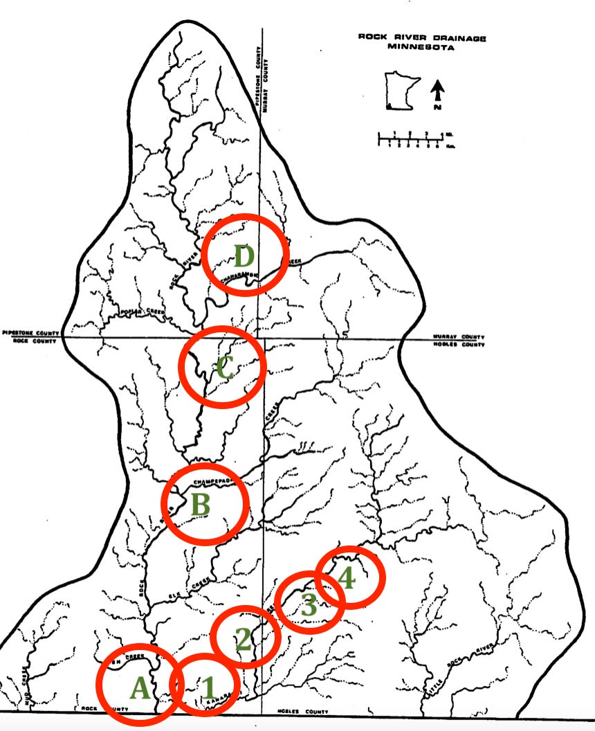
Figure 2---- Rock River Watershed with multi-component sites located along Kanaranzi Creek (numbers) and along the Rock River (letters). Gibbon (1980).
Kanaranzi Creek is a tributary of the Rock River and that watershed also has ancient campsites strung out along travel corridors. Figure 2 shows the approximate locations of the four sites on Kanaranzi Creek: 1 is Lone Tree Farm, 2 is the bison skull, 3 is the battle ground, and 4 is the upland field. But, Figure 2 also shows places within the Rock River watershed that may also be ancient campgrounds along a travel corridor. And, a number of these locations have been studied by archaeologists.
In southern Rock County along the main stem of the river ( A, Figure 2) there are published accounts (Arzigian and Stevenson, 2003) of Native American mounds. It is unclear how they may be related to the extensive mound complex at Blood Run because the ages are speculative. Farther north there are multicomponent sites (Gibbon, 1980) along the Rock River (B, Figure 2) that include both the older (“Archaic” from 7500 to 500 B. C.) and the younger (“Woodland” less than 1000 A. D.) cultures that moved along the Kanaranzi Creek. In the northeastern corner of the county, there’s a township named “Battle Plain” ( C, Figure 2). A history of the county written in the early 1900s (Rose, 1911) includes a newspaper account that claims there was a battle between the Dakota and Ponca in this area. Still farther upstream, there’s a tributary (Gibbon, 1980) that has a concentration of the old (“Archaic”) sites (D, Figure 2)
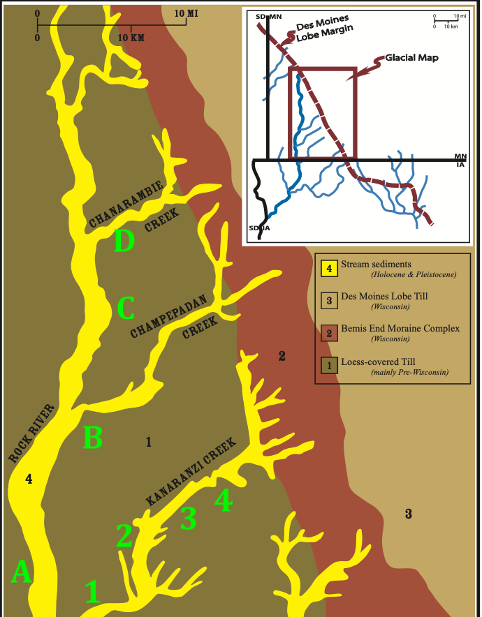
Figure 3----Map of glacial deposits generalized from Patterson, 1995, showing multi-components sites along Kanaranzi Creek (numbers) and the Rock River (letters). Figure modified from Shurr (2011).
The Rock River and it’s tributaries have broad valleys filled with alluvium deposited by meltwater streams off the front of the last major glacier. These streams originate in the end moraine system (brown area labeled “2”, Figure 3) that separates younger glacial sediments to the northeast from older glacial and wind deposits to the southwest. The ecosystem to the northeast is part of the “Prairie Lakes” region (Anfinson, 1997) where Native people grew corn and hunted deer and bison, but also harvested wild rice and used other resources associated with the glacial lakes. The ecosystem to the southwest was dominated by big rivers that cut deep valleys into the older glacial deposits. Native people here didn’t have the lakes for food sources so they cultivated extensive corn fields and vegetable gardens and hunted bison. The Rock River and it’s tributaries constituted travel corridors between these two contrasting ecosystems for many thousands of years and the people moving along these corridors left a record in the ancient campsites (Figure 3, 1 through 4 and A through B).
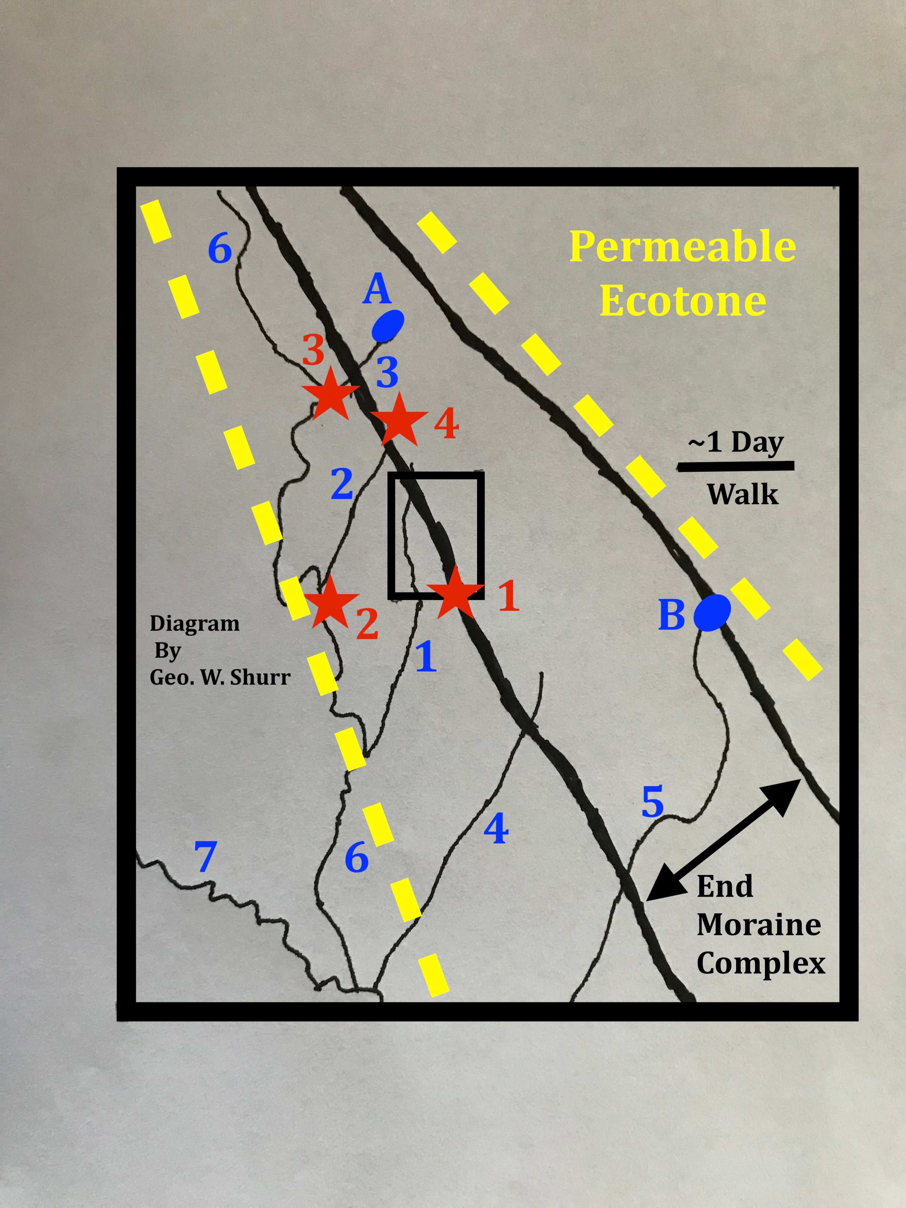
Figure 4---- Generalized sketch map of the permeable ecotone. Numbers and letters are referenced in the text.
The Rock River and it’s tributaries are part of the Big Sioux watershed and other streams in that larger watershed probably also served as travel corridors that hosted ancient campsites. The diagram in Figure 4 shows a simplified version of the permeable ecotone that includes the end moraine complex and the streams leading up into the morainic hills. The black rectangle outlines the area of Figure 3, the red star labeled 1 is the Farm and the stream with the blue 1 is the Rock River. Other probable ancient campsites are shown by red stars: Blood Run, IA (2), Flandreau, SD (3), and Pipestone, MN (4). Other possible travel corridors include Split Rock Creek and Flandreau Creek (blue 2 and 3) which are tributaries to the Big Sioux River (blue 6). There may also be travel corridors along the Floyd River and the Little Sioux River (blue 4 and 5); like the Big Sioux (6) they are tributaries to the Missouri River (blue 7).
The character of the ecotone seems to change to the southeast as the end moraine expands and widens and as tributaries to the Big Sioux give way to travel corridors on other rivers. There are essentially no natural lakes south and west of the end moraine complex, but two contrasting lakes anchor this sector of the ecotone: Lake Benton, MN, in the north and Big Spirit Lake, IA, in the south (A and B respectively in Figure 5). Although Lake Benton is in a distinctive steep-sided “tunnel valley” and Big Spirit Lake is in an area of low rolling hills, both lakes have an ancient campground (aka, multi-component archaeological site) and an associated stream to provide a travel corridor. For Lake Benton, the stream is Flandreau Creek and the site is called the Pederson Site (21LN002). For Big Spirit Lake, the stream is the Little Sioux River and there is also a possible multi-component site located in Mini-Wakan State Park (13DK143), although the results of a recent excavation by the Iowa Office of the State Archaeologist are not yet readily available.
This ecotone is not a simple, clean line like that between a floodplain and an upland. Instead, it’s a relatively wide area that has ancient campsites and travel corridors. And, people moved through the area using the campsites and corridors as they traveled between the northeastern ecosystem with foodways based on lakes and the southwestern ecosystem with foodways based on corn and bison. That happened along half a dozen streams in the Land at the Edge of the Sky, including Kanaranzi Creek and the Creek has shared that history with us.
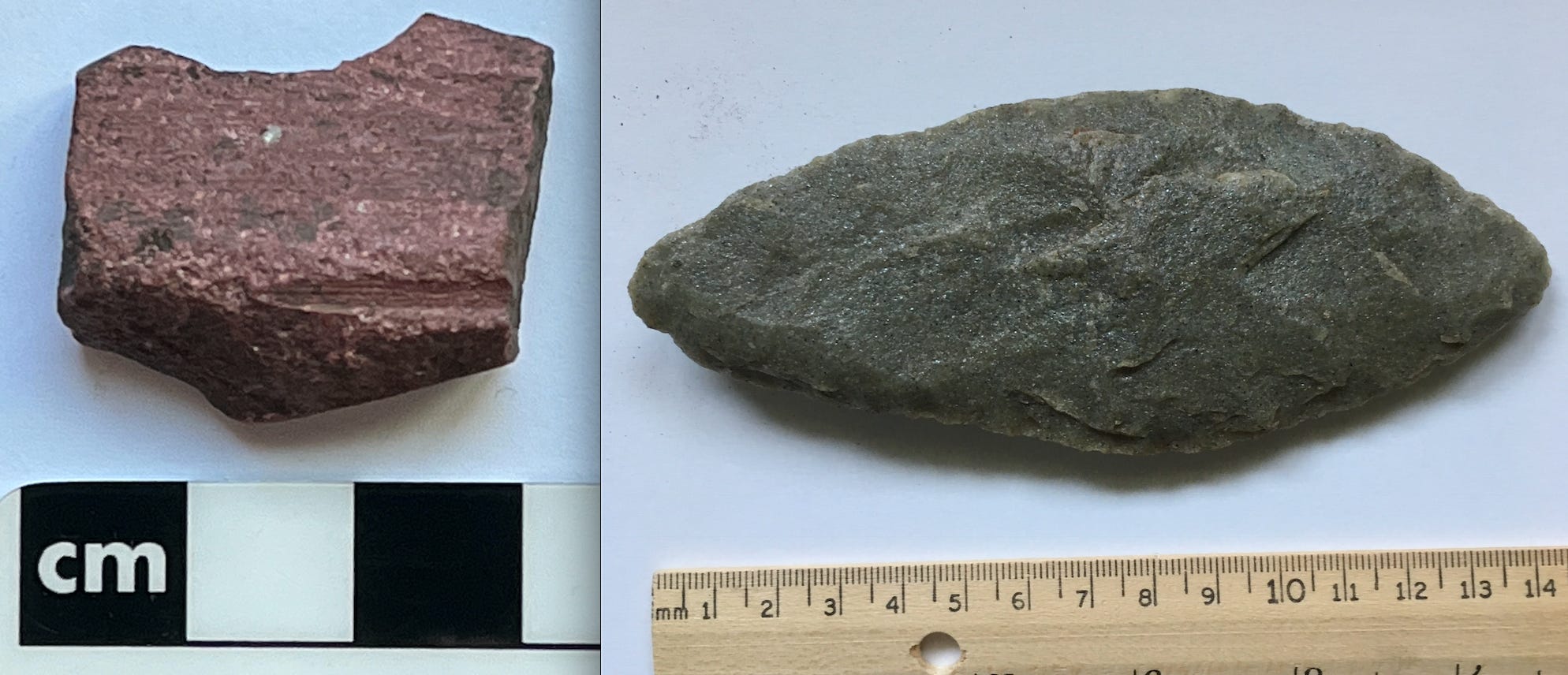
Figure 5----Artifacts from Lone Tree Farm that suggest a connection to Blood Run. A) Grooved pipestone piece. B)Biface made of Bijou Quartzite.
The next series of posts will take us back to Blood Run National Historic Landmark (NHL) located near Sioux Falls, SD, about 30 miles straight west of the Farm. There are two main artifacts that tie Lone Tree Farm to Blood Run. A few small pieces of pipestone (A, Figure 5) have been collected on the Farm and Blood Run has a lot of the material because it was probably a trade center where pipestone objects were fabricated. Also, Bijou Quartzite bifaces/blades (B, Figure 5) have been found on the Farm and they are characteristic of artifact assemblages (Johnson, 2023) associated with the Omaha and Ponca tribes who are the descendants of the people who lived at Blood Run. So, the ancient campsite at the Farm may be related to a possible ancient campsite at Blood Run.
“AND, NOW FOR SOMETHING COMPLETELY DIFFERENT”:
The next post will be a short story that will take us back to Blood Run for a tour with a bunch of professors. It’s fiction but it is based on some actual events.
A NOTE ON REFERENCES:
There are a number of publications cited in this current post, but there’s not a formal list compiled. If you’d like to know the details about a specific publication, please send me an email and I’ll get a complete citation to you.
The permeable ecotone you identify around the creek helps me understand why this place would have had so many various peoples and cultures move through it over the centuries. This place had so much to offer all within a day's walk. Fishing, trapping, hunting, farming, harvesting wild rice. The proximity to Spirit Lake caught my attention since I'd written this weekend about a Civil War Veteran buried in Warroad who had been a child in 1856 when a wagon train from Pennsylvania arrived in the area. Your longer view of history in this area shows me a different kind of relationship to the land than our present notions. "Camps" are homes. While many scholars in the mid-nineteenth century described Indian tribes of the woods and plains as "nomadic" this isn't exactly accurate. They moved to various locations within their home area in accordance with the availability of natural resources (fish, game, rice, etc.). Many of us today have summer cabins and that's as close as we'll get to understanding this kind of seasonal residence of the Dakota in southwestern Minnesota. That so many different cultures are represented across time in this one location also shows me how waterways were the "interstate highways" of the past. It might also speak to the power of the place itself as hospitable to humans. And perhaps a place where peoples gathered to talk, trade, pray. I'm fascinated by your findings, George, and look forward to reading more.
Thanks, for your comments, Jill. I especially liked the identification of "camps" as "homes" and the parallel of Native American "seasonal rounds" with the "summer lake cabins" that we all are more familiar with. And, there's power a concrete place. Native Americans are particularly rooted in their homelands and their cultures are as diverse as the landscape they live in....right now as well as in the past.