


Flooding at Lone Tree Farm
How Archaeology Intersects with Bridge Design

The original plan was to have this post start a new series on the Blood Run National Historic Landmark (NHL), after the experimental short story of the previous post provided an introduction. But Nature intervened and so the next several posts will continue a focus on Lone Tree Farm located about 30 miles east of Blood Run NHL. We’ll come back to Blood Run (because I’ve basically got that first post all ready to go) after we look at the generational flooding of June, 2014, and how bridge design can potentially pose a threat to an archaeological site.
The rain started on Thursday, June 20, and continued for several days. Total rainfall amounts in the general area ran about 10 inches, but there were local reports of up to 17 and 18 inches! About 8 inches fell at the Farm. Kanaranzi Creek flooded the pasture, the adjacent roadway including the “Stateline Bridge”, and a nearby archaeological site. People living in the neighborhood said it reminded them of old country and western songs like Johnny Cash’s “How High’s the water, Mama?” (1959) and “Oceanfront Property” by George Strait (1989)!
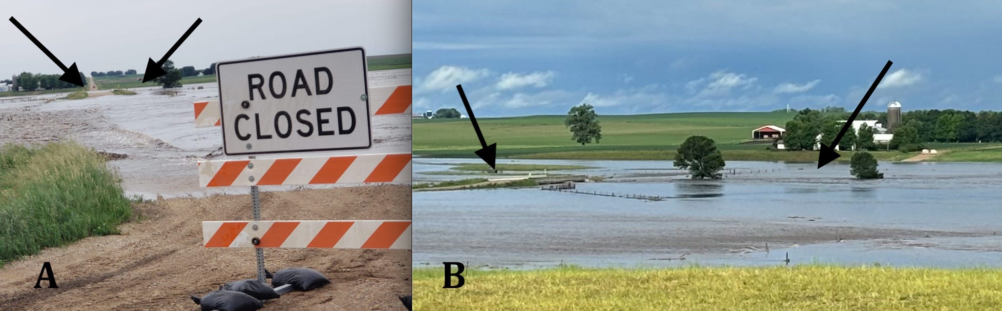
Figure 1----Flood on the Stateline. Left arrow points to the bridge and right arrow points to the archaeological site in both photos. A) Friday night. Photo by Donna Wibben. B) Saturday morning. Photo by Amy Leuthold.
After two days of rain, the Creek flooded the road and the barrier went up on Friday night (Figure 1-A). On Saturday morning, the water level had somewhat dropped from its peak so that the bridge was more clearly out of the water (Figure 1-B). However, the archaeological site to the west of the Bridge was still under water. You can see the road barriers on the hill west of the flooded valley bottom. Both of these two flow conditions on the Kanaranzi correspond with specific water levels on the Rock River at Rock Rapids, Iowa, about 6 miles downstream to the south of the Bridge.
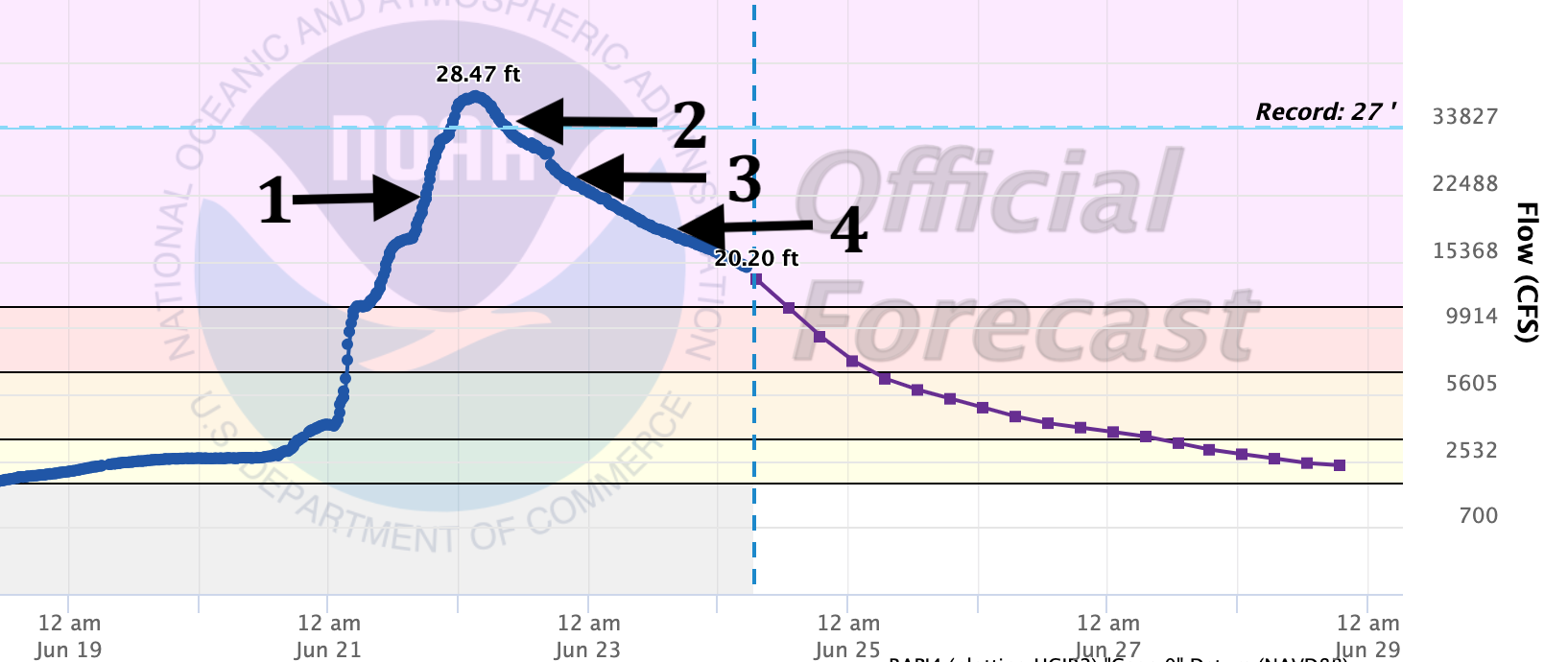
Figure 2. Observed and predicted water levels and flow conditions on the Rock River at Rock Rapids, Iowa.
Flood predictions made by the National Oceanographic and Atmospheric Administration (NOAA) are based on observations recorded at the United States Geological Survey (USGS) stream gauge (Figure 2). The gauge is located just downstream from the mouth of the Kanaranzi where it empties into the Rock River, so it provides a numerical picture of what’s happening back up at the Stateline Bridge. At position 1 on Friday night, the Rock River water level was 23.8 ft and the barriers went up on the Stateline (Figure 1-A). The flood peaked around 3:00am at 28.5 ft; the previous record was 27 ft set in 2014. By Saturday morning (Figure 1-B) the water level had dropped to 27.1 ft (position 2, Figure 2) and continued to decline to 24.8 ft on Saturday evening and 21.8 ft by Sunday evening (positions 3 and 4, Figure 2). The predictions shown as the purple line to the right of the 20.2 ft position pretty well follow the observations shown as the blue line.

Figure 3---More pictures of conditions at the Stateline Bridge. A) Saturday evening, position 3, Figure 2. B) Sunday evening, position 4, Figure 2. Both photos by Amy Leuthold.
By Saturday evening (Figure 3-A) water levels had dropped enough for patches of “dry” land to appear and by Sunday evening (Figure 3-B) the bridge had really emerged from high water. However, the areas covered by water show up as gray and black because there’s dirt on the grass in those places. That’s a problem because now the cattle can’t graze there. And, there are other problems in the neighborhood: basements flooded, livestock stranded on small emergent areas, fences wiped out, row crops drowned, and roads damaged.
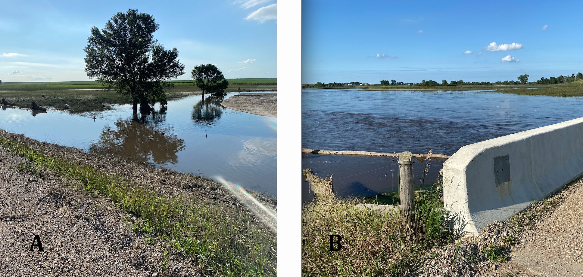
Figure 4----Views from the bridge on Sunday night. A) Emergent archaeological site. B) Flooded main channel. Both photos by Nancy Popkes.
But, what about the fate of the archaeological site? By Sunday night the water was off the site (the grass area to the left of the tree in Figure 4-A), but the main channel was still at bank full flow (Figure 4-B). The concrete deck of the Bridge was never overtopped; the water levels stayed below that by design. The main structure was supposed to be protected because the dirt-filled approaches will erode away leaving the infrastructure intact. That’s the plan and it seemed to work well. However, that repair work would probably pose a threat to the archaeological site because that’s the logical place to get the dirt fill needed to replace the bridge approaches. The bridge structure would be safe, but the borrow pit would most likely destroy the archaeological site.
The bridge was built about 15 years ago and the design worked well in the 2014 event listed as the previous record of 27 ft at the Rock Rapids stream gauge (Figure 2). However, there are no records before 2004 because that’s when the gauge was put in. There’s a strong collective memory in the neighborhood about the flooding of 1993. Pasture fences along the Creek had to be replaced multiple times and the 1993 flood impacted a large area of northwestern Iowa and adjacent Minnesota and South Dakota.
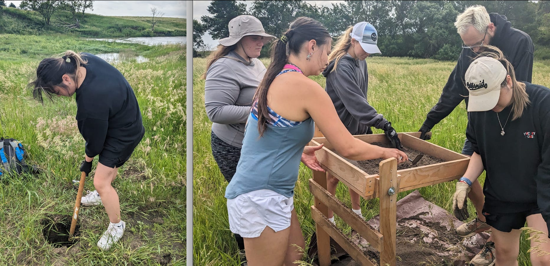
Figure 5----Augustana University’s Field School for archaeology students. Photo by Dr. Phyllis Johnson.
Ironically, during the two weeks leading up to the flood there was a lot of archaeology work going on at Lone Tree Farm (Figure 5). The activity shown in Figure 5 was not at the Bridge Site, but it was at a separate site that also went under water. It was still mostly covered by water as of yesterday. In the next post we’ll look at specifically what studies have been done at the Bridge Site, how those investigations may help to protect the site, and why the flooding will probably lead to new discoveries. The Creek has information to share and stories to tell if we just know how to listen.
ACKNOWLEDEMENTS:
Thanks to these people who provided real-time perspectives and photos while the flooding happened: Dan and Amy Leuthold, Nancy Popkes, Donna Wibben, and Dr. Phyllis Johnson.
Really helpful update & context. In addition to all of the other effects, it will be interesting to see how wildlife respond to these changes, especially those that depend on that stream & it's oxbows. We've had 3vyrs of serious drought & now deluge. Boom & bust have always occurred yet they appear to be becoming more extreme & more frequent
I wondered whether the torrential rains that flooded much of the state of Minnesota had affected Bull Run Creek. A fascinating report of what happened with clear presentation of factual information. You let the creek speak for itself in a roaring voice. Wow.