
Floodplain Sites
The Land Has Layers of Memories

One of the most common ways for new archaeological sites to be “discovered” is for laypeople to pick up artifacts. When trained archaeologists make the “finds” the exercise is called a “pedestrian survey” and the finds are called “surface collections”. But the professionals also dig excavation units and use shovels to test smaller areas. Those collections are more significant because they are “in place” within the soil layers and have context for interpretations. One of the floodplain sites, informally called Bar C, is based mainly on surface collections made by both family members and professionals; it’ll soon be submitted for designation as a formal, numbered site. The other site already has a formal number, 21RK82, and it has also had excavations and other work done by professional archaeologists.
The last post looked at two sites on Lone Tree Farm that are located along the hillslope between the upland surface and the floodplain. These sites have not been assigned numbers, but also have defining aspects other than just artifacts. Rocks, plants, and water distributed through a limited area can potentially help to define the sites. In this post we’ll move downslope to look at two sites on the floodplain of Kanaranzi Creek in this same general area. The surface collections, excavations, and shovel tests done by professional archaeologists are the basis for outlining the area of a site. However, collections made by family members over the years also provide material. And the adjacent rocks, trees, and springs add to our understanding.
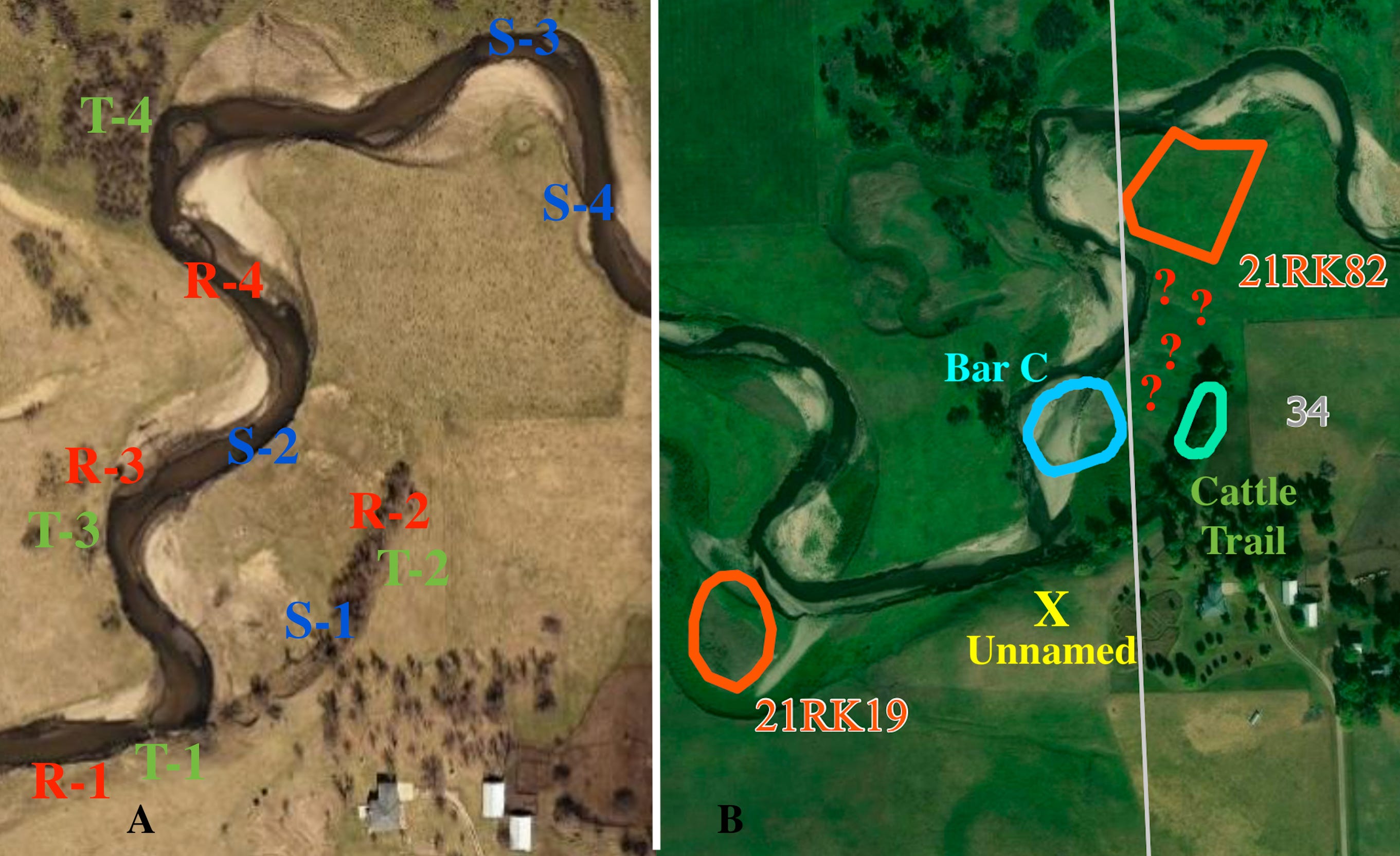
Figure1----Maps of the area around 21RK82 and Bar C. A) Fall image with specific locations of significant rocks, trees and springs identified. B) Summer image with archaeology sites outlined. Site 21RK19 will be discussed in the next post and the Unnamed and Cattle Trail sites were described in the last post.
Rocks, trees, and springs are associated with the two hillslope sites (Figure 1-A). A rock that’s now buried (R-1) is near the former location of the old Lone Tree (T-1) and rocks are also found at the Cattle Trail Site that has a wild plum thicket at the top of the hill (R-2 and T-2). Landslides triggered by springs (S-1) are found all along the hillslope. These springs probably flow from fractured glacial sediments, but the springs on the floodplain (S-2, S-3, and S-4) are associated with buried sand and gravel. There’s a large cottonwood tree (T-3) that we think is an offspring of the original Lone Tree and it has a rock (R-3) nearby that was only recently exposed by the channel erosion. There are also rocks within the channel just upstream (R-4) with a wild plum thicket (T-4) on the adjacent floodplain surface.
However, the current archaeological sites are mainly based on the outlined areas where artifacts have been collected from the surface or dug up in excavations or shovel tests (Figure1-B). We’re going to focus on the outlined floodplain sites called Bar C and 21RK82. Should those outlined areas be enlarged to include elements like rocks, trees, and springs? Bar C wouldn’t need to be very much larger to incorporate those additional elements. However, the area for 21RK82 would have to be substantially bigger in order to add the rocks, trees, and springs. Also, could 21RK82 possibly be expanded to the south to include Bar C because there are archaeological aspects shared between these two sites? The answer to that question is in the area between the sites marked by red “?”s.
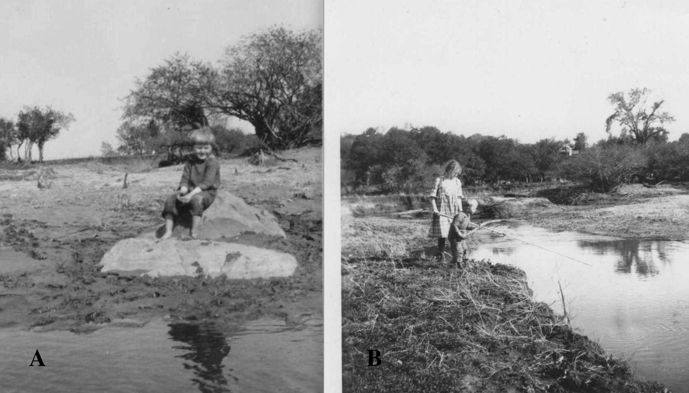
Figure 2----Two photos from the 1920s. A) My Dad on a rock (R-1, Figure 1) at the site of the old Lone Tree. B) Dad and his older sister fishing near a spring (S-2, Figure1).
So, the Land has layers that remember glacial ice and meltwater streams. And, it has layers of wind-blown silt on the upland surface with alluvium deposited on the floodplain along Kanaranzi Creek. But it also has memories of the family that has lived and worked here since the early 1870’s. The rock that Dad is sitting on in Figure 2-A is the one now buried at the Unnamed site; look at all of the small wild plum trees behind him. There are also extensive wild plum thickets across the Creek from where the kids are fishing in Figure 2-B. The tall tree in the background above the plum thickets is the Lone Tree. The stream bank where those kids are standing has layers that preserve the history of glaciers and ancient streams of meltwater as well as the more recent floods and erosion along Kanaranzi Creek. Some aspects of the landscape have changed and some are still pretty much the same. But the memories are all still preserved.
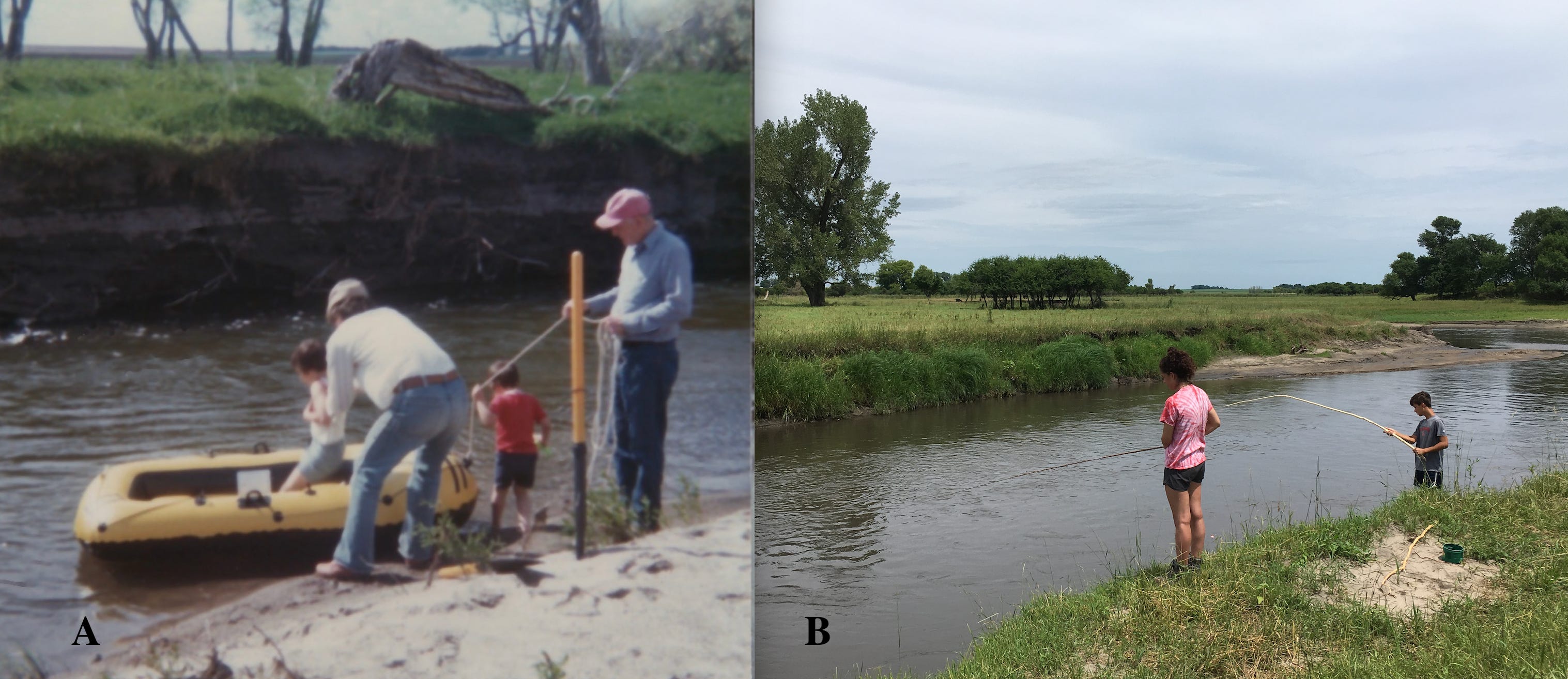
Figure 3----A) Dad and I with my two kids in the late 1970s. B) Two of my grandkids in the 2010s.
The launch of the yellow rubber raft in Figure 3-A took place on Bar C across the Creek from the rock (R-3, Figure 1-A) recently exposed by erosion. Those are my children in and beside the raft and now they both have kids in college! The two layers visible in the far bank hold the record of Native American tools and buffalo bones. My two grandkids in Figure 3-B are fishing at essentially the location of the rock where Dad was sitting (Figure 2-A) about 100 years before that. The large cottonwood tree at the left side of the photo is the possible descendent of the original Lone Tree (T-3, Figure 1-A). It also has small wild plum trees nearby. However, between the ancient memories recorded in the layers of glacial sediments and the more recent memories enshrined in photographs, there is a long history of Native American activities memorialized in the animal bones and tools found in the outlined archaeological sites (Figure 1-B).
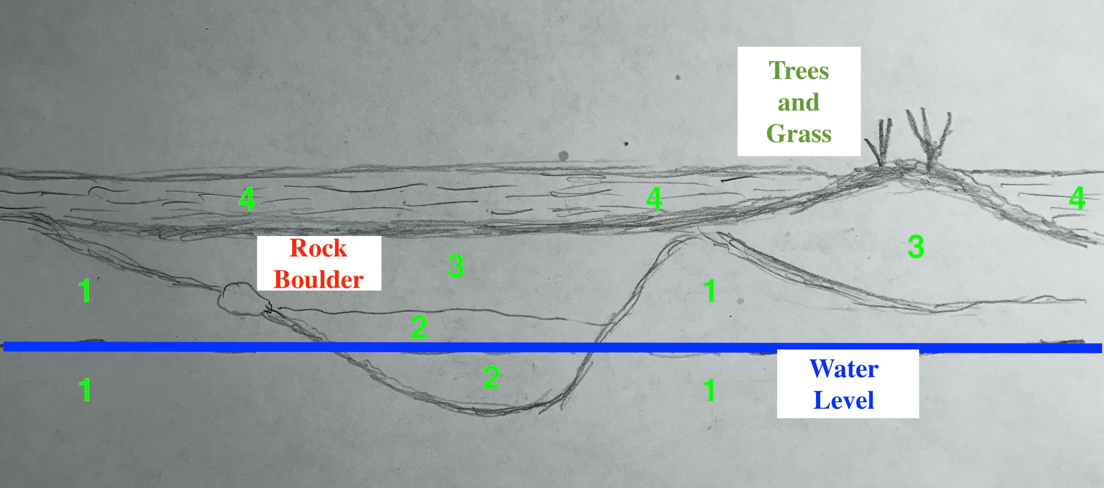
Figure 4----Cartoon showing the idealized relationships between four primary layers of sediment that are exposed in the cutbanks along Kanaranzi Creek. Units 1 through 4 are described in the text.
Dark gray clay with cobbles and boulders mixed in, is the lowest and oldest of the four units (Unit 1, Figure 4). This material is called “till” and was deposited directly by glacial ice and underlies the entire area…. floodplains, hillslopes, and upland surfaces. The top of the layer is highly irregular because it was eroded into high and low areas by streams of water from the melting glacier. Back thousands of years ago during the Ice Ages, those meltwater streams also deposited well-sorted sand and gravel, called “outwash” (Unit 2, Figure 4). Units 1 and 2 were subsequently eroded and were buried by more recent stream sediments. There are two layers of stream deposits called “alluvium”. The older, lower one (Unit 3, Figure 4) is dark colored and composed mainly of silt and clay. The younger, upper layer (Unit 4, Figure 4) is lighter colored and has more sand and gravel. These two layers deposited by streams long after the Ice Ages, are where the Native American artifacts and buffalo bones are found.
The rocks in the glacial till are isolated boulders not connected to the deeper bedrock. So, they are different than the outcrops that we looked at Gitchie Manitou State Preserve in northwest Iowa and in Blue Mounds State Park in southwest Minnesota. The water level in the Creek changes depending on the rainfall, but there’s also a free exchange between the buried outwash and the water in the channel. The water level extends out into groundwater beyond the water surface on the stream in the channel. That’s why there are springs along some of the Creek banks. So, this whole hydrological setup is much different than the hillslope springs. Finally, not only trees, like cottonwoods and wild plums, but also prairie grasses and plants like sage are found associated with archaeological sites.
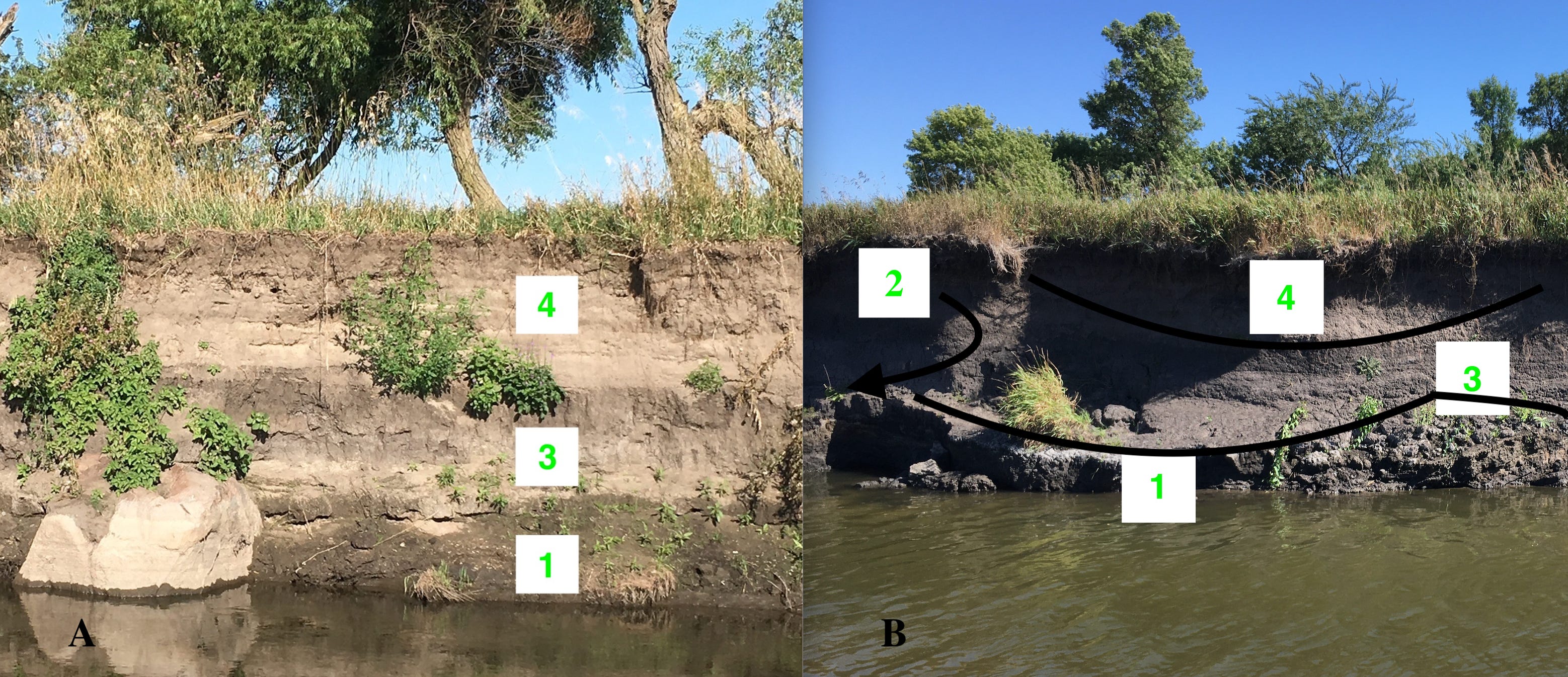
Figure 5----Photos of layers of sediments exposed in cutbanks along the Creek. A) West bank located straight across from Bar C site. B) East bank located just upstream from Bar C site.
We often tend to think of sediment layers as flat with relatively smooth boundaries between them. In some places (Figure 5-A) that’s true. The oldest lower layer of dark glacial till is covered by the dark stream alluvium which is in turn overlain by the light-colored stream alluvium (Units 1, 3, and 4 respectively). The boulder at the left side of the photo emerged from hiding after the Creek bank eroded back during the past ten years. Maybe this boulder will go back out of sight again if the Creek sediments cover it like the rock buried near the Lone Tree location (R-3 and R-1, Figure 1).
But the surfaces of layers of sediments are often not simple, flat surfaces. For example, the top of the old glacial till (Unit 1) is eroded into highs and lows covered by outwash sand and gravel (Unit 2) exposed just off to the left side of the photo (Figure 5-B). Both the till and outwash are covered by the older, dark alluvium (Unit 3) with the younger lighter-colored alluvium (Unit 4) filling a low spot cut down into the upper surface. These are the geometries that influence groundwater movement and springs as well as controlling the distribution of artifacts and animal bones.
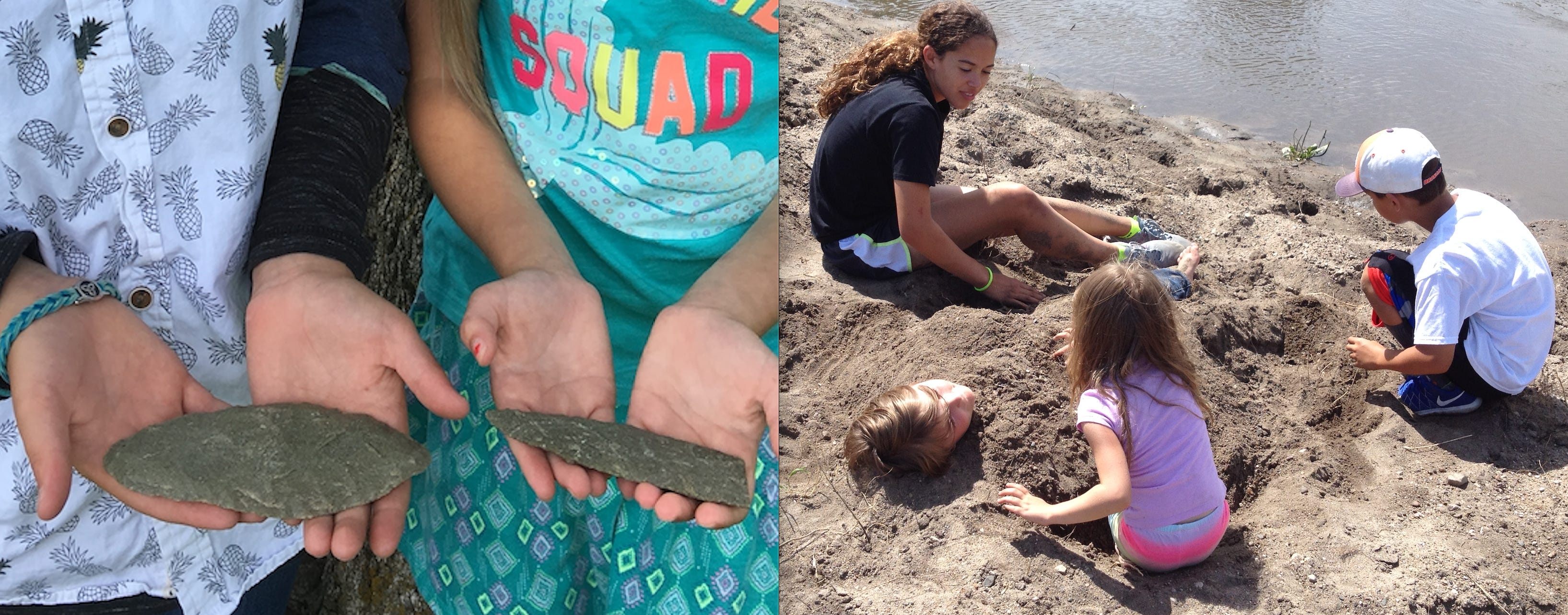
Figure 6----Grandchildren on Bar C. A) Distinctive blades found by the kids who are holding them. B) All four of our grandchildren playing in the sand when they were much younger.
Two of the most important artifacts collected from Bar C are the two bifaces/blades shown in Figure 6-A. They are made of a unique rock type that’s also found extensively at Blood Run National Historic Landmark. So, these blades suggest a tie to the large archaeological complex at Blood Run and I was standing right next to the kids when they picked them up! But there’s also evidence for links to an older cultural group in another part of northwest Iowa. I collected two pieces of pottery on Bar C that archaeologists have confirmed as components of that earlier culture.
The kids who collected the blades are the two closest to the camera, buried in the sand and drawing on the top of the sand pile (Figure 6-B). The other two kids closer to the Creek water are the ones shown fishing in Figure 3-B. It was their dog who found a buffalo skull on Bar C. And I was standing right next to him when he discovered it! I may not find the important stuff but at least I’m nearby when the big discoveries are made! The skull has a radiocarbon date that approximates the time of the cultural tradition that produced the pottery. Consequently, Bar C is a “multi-component” site with a record of several different Native American cultures. That’s also true for the formal site located nearby: 21RK82.
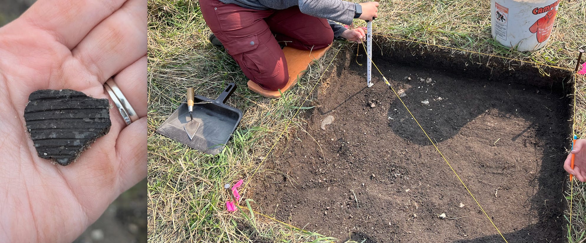
Figure 7----Scenes from the archaeologists at work in Site 21RK82. A) Piece of pottery they found along a Creek bank. B) Measuring locations within the first excavation unit that was put in.
A lot of work has been done by professional archaeologists at 21RK82; there’s a description of most of that effort here. I’ll just summarize some of results briefly and also add some newer information. This past summer during the archaeological field school conducted by Augustana University there was a piece of pottery (Figure 7-A) collected at Site 21RK82. It’s thought to be similar to the pottery fragments from Bar C, so the two sites share the older cultural component. This is in addition to material found in an excavation several years ago (Figure 7-B). A gravel layer probably marking the base of Unit 4 contained an artifact possibly made from the same distinctive rock that is in the blades that the kids found on Bar C. So, the sites possibly also share the younger cultural group associated with Blood Run. The gravel layer also contained a tooth and seeds that were submitted for radiocarbon dating.
Unfortunately, the tooth and seeds didn’t provide enough material to establish a reliable date. However, bone material from the bottom of an excavation done in this year’s field school produced some really exciting results. It’s much older than either of the two cultural traditions shared with Bar C. In fact, it goes back almost 5,000 years so it’s similar in age to some of the projectile points found at the surface (Johnson, 2023). But this bone was collected “in place” at a depth of about 3 ft, probably within the older stream alluvium of Unit 3. So, the multiple cultural components at Site 21RK82 extend way back into deep time.
In the next post we’ll look at two more sites located on the floodplain of Kanaranzi Creek and revisit the issue of site size and the business of including rocks, water, and plants. In the meantime, here’s the main take away from this sorta long current post:
The Land remembers. And people are part of the Land. There is a collective memory of the families who lived and worked and worshiped here thousands of years ago, hundreds of years ago, and tens of years ago. And memories continue to be made with the family who lives here now. Maybe the Land does not “have” memories. Maybe the Land itself IS layers of memories stored in the layers of sediment, in the rocks and water and plants, in the artifacts and buffalo bones, and in the photographs of children.
I hope that you all had a good holiday celebration!
So fascinating to take a deep long look at one place over time and see these layers.