
Technical and Traditional
Seeking Two Versions of the Same Story

In the last post I described Site 21RK19, but it could be called the “Oxbow Site” because it’s located in the vicinity of a cut-off channel meander. In this post we’ll look at a second archaeological site on Lone Tree Farm that has been formally registered with the state and assigned a “Smithsonian Number”. This newer site has the number 21RK82. Although the numbers do seem to make the whole process “scientific”, it’s more confusing than just having names that are easier to remember. For example, I used the wrong number for Site 21RK82 all throughout early drafts of the previous post! So, let’s call Site 21RK82 the “Circular Features Site” because it’s where we started using high-tech, noninvasive tools to establish the importance of circles in the grass visible on air photos and on the ground. All of this is part of an effort to understand the story that the Creek is trying to tell us.
The Circular Features Site (21RK82) has been described in a paper published by the Minnesota Archaeological Society (Messarole, 2020), but that summary is based on work done two years earlier (Messerole, 2018). Although some of the artifacts and bones included in the published report were actually found outside of the current boundary of the Circular Features Site, we’ll mainly focus here on the details associated with the gradiometer survey area and the nearby sandbars. That will include the results of two visits by Native Americans: one group was with Tribal History Preservation Officers and the second group accompanied a Tribal Elder who is a traditional knowledge keeper. As a result, we have information that the Creek is trying to share from the perspective of technical archaeologic work and with the insights provided by traditional tribal knowledge.
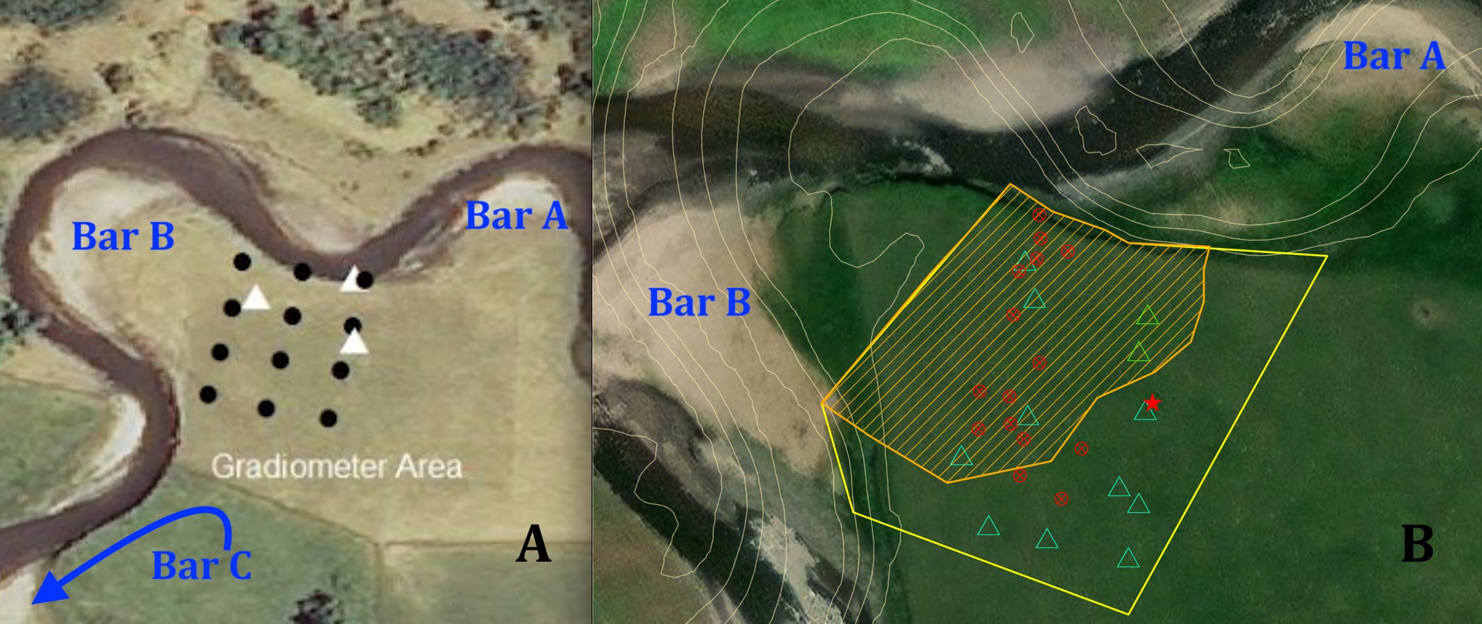
Figure 1----Maps of the Circular Features Site (21RK82). A) Overall view of survey area grid points with surface vegetation anomalies shown as white triangles (Messerole, 2018). B) Closer view showing oblong gradiometer anomalies as red circles, possible fire hearths as green triangles, and the location of a corner of the excavation pit as a red star (Wiebelhaus and Johnson, in prep.).
Back in 2015 family members found two arrowheads/projectile points on Bar A (Figure 1-A). One has been identified as a type that dates to 7500 to 500 BC (Johnson, 2023); the other has not yet been described in technical detail. In addition, family members have also collected a number of artifacts from Bar B over the years. Most were chips and flakes that had been used for scraping and cutting. Bar C located just to the southwest has also yielded a number of important artifacts that will be assigned to a newly designated site that will be described in the next post.
The gradiometer survey completed in 2018 identified a set of large circular magnetic anomalies interpreted to be a dwelling; the magnetic anomalies corresponded with the location of circular vegetation anomalies. There also were smaller circular magnetic anomalies that might be cache pits, oblong anomalies that may represent interments, and other specific anomalies that may mark the locations of fire hearths (1-B). In 2023 Tribal Colleagues excluded the area shown with orange ruling from any disruption. Consequently, the red star marks the location of the 1 meter by 1 meter “unit” that was subsequently excavated to try to confirm if a particular magnetic anomaly does mark the remains of a fire hearth.
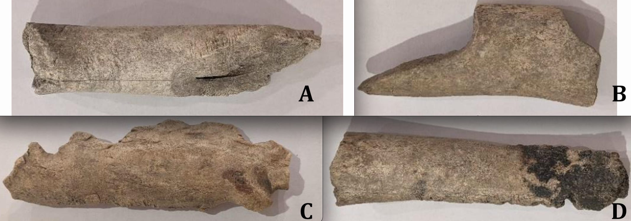
Figure 2----Buffalo/bison bones found in the and around the Circular Features Site (Johnson, 2023). A) Cut marks. B) Broken. C) Bone shaped into a tool. D) Burned bone.
In addition to artifacts and anomalies, buffalo/bison bones have been found on Bars A and B and also to the southwest toward Bar C (Figure 1). Some of the bones show cut marks that indicate butchering (Figure 2-A) while others have distinctive fractures that are evidence of breaking (Figure 2-B). There is at least one bone that has been modified to use as a tool (Figure 2-C) and there are a number of bones that have been burned (Figure 2-D). These bones along with the skulls at the Oxbow Site suggest that the butchering and hunting may have been done locally at these sites, rather than on some long-range trip to a remote huge heard. Radiocarbon dates on two bones give the years 1256 AD and 1769 AD (Johnson, 2023) which effectively bracket the dates of 1390 AD and 1600 AD on skulls from the Oxbow Site.
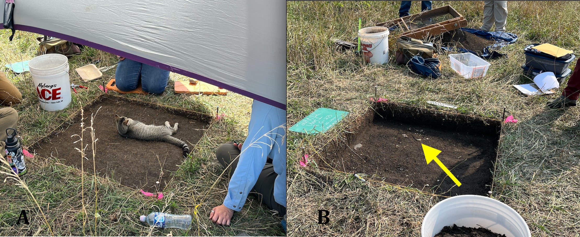
Figure 3----Two early views of the excavation unit put in near the margin of the Circular Features Site. A) The local farm cat was a “helper”. B) Later and a little deeper in the process, some significant material was uncovered.
Following the guidance of our Tribal Colleagues, a gradiometer anomaly to be “tested” by excavation was located near the eastern margin of the site. A 1x1 meter square was laid out and a sun shade put up. The local farm cat also appreciated the shade early in the excavation process (Figure 3-A). A little deeper a layer of small gravel showed up. It contained a bison tooth and possible pumpkin seeds (yellow arrow, Figure 3-B) as well as flakes from making tools and a possible artifact. The tooth and seeds will be good candidates for radiocarbon dating. The photo also displays some of the equipment used during the digging.
These are preliminary interpretations. More data has been collected in the lab where the soil removed during the excavation has been sieved and run through a floatation procedure to separate the lighter vegetation remains from the heavier lithic material. The work of identifying plants and artifacts in these samples has not yet been fully completed. But, it’s possible that this gravel layer may be associated with a fire hearth as suggested by the gradiometer anomaly.
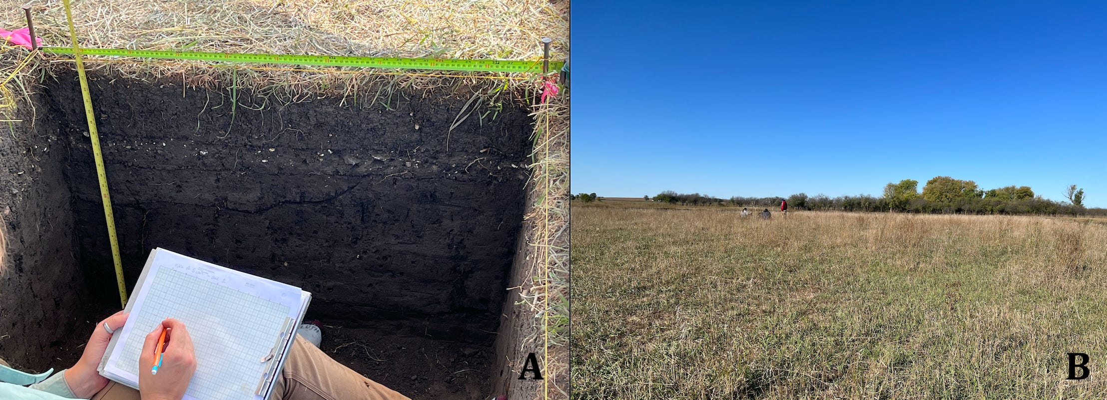
Figure 4----Two types of activities at work in the Circular Features Site. A) Recording measurements in the excavation unit. B) Making the observations and doing the ceremonies that facilitate learning what the Creek wants us to know.
Later in the excavation, that gravel layer was located high on the wall of the deeper pit (Figure 4-A). Although not much large archaeological material was recovered from below the gravel, there might be small artifacts extracted from the soil samples in the lab. In any case, measurements are made of everything observed in the field and recorded for future reference.
In contrast with these “technical” measurements and observations, the group accompanying the Tribal Elder made a different set of observations and conducted the ceremonies that help them to understand the importance of the site (Figure 4-B). The photo is taken at a respectful distance that preserves their privacy.
I recently described this activity in a conversation with a professional archaeologist who works in a management position in a government agency. I was really disappointed and surprised when he commented that the Elder’s intuition should be no more significant than anyone else’s. That’s ironic because I’ll bet that he would also think that a trained archaeologist’s intuition IS better than a person with no formal training. However, the Elder and the people who accompanied him understand the language of the Land that has been handed down to them from their ancestors. That resilience provides a perspective that is valuable and should be incorporated into our understanding of this place.
It's gratifying to know that not all professional archaeologists would agree with the government manager. The author of a paper about Blood Run that was just recently published (Benn, 2025) clearly articulates an alternative position that affirms the importance of what Traditional Knowledge Keepers have to share with us.
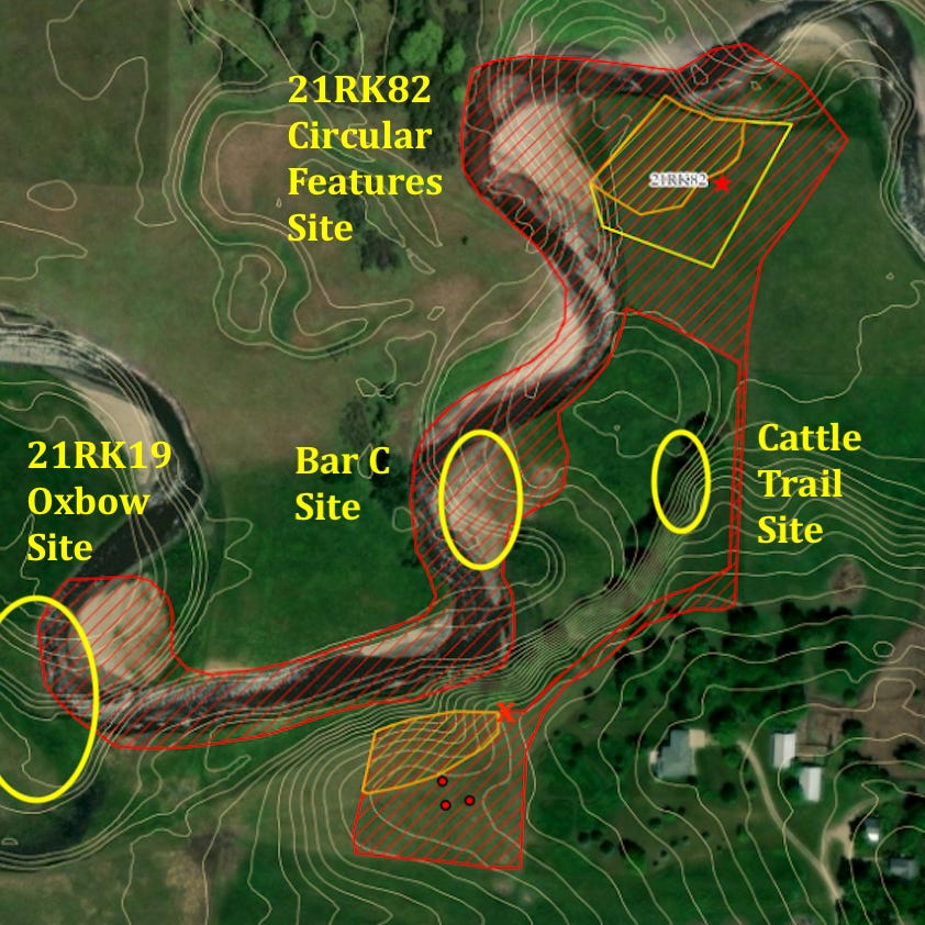
Figure 5----Map of the Circular Features Site and others located nearby. The patterns in the Circular Features Site are the same as those used in Figure 1-B.
To wrap up this post, let me get off my soapbox to review some other work that’s been done in the area of the Circular Features Site and also preview the next post. The archaeologists from Augustana walked through part of the pasture (shown by the outline with red ruling, Figure 5) looking for artifacts on the surface. This is known as a “pedestrian survey” and it covered areas around the two numbered sites as well as the two informal, unnumbered sites that will be described in the next post. It also included the hilltop overlooking all four sites.
A portion of that hilltop was excluded (orange ruling, Figure 5) from any archaeological digging because our Tribal Colleagues believed that it was important. Like the excavation unit in the Circular Features Site (red star, Figure 5) that determination guided the location of three “shovel tests” (red dots, Figure 5) that turned up no artifacts. However in past years, a family member did collect an artifact on the edge of the hill (red X, Figure 5). That’s near the location of the “lone tree” that gave the farm it’s name and also close to where we think that the homesteaders had the “dugout” that was their first home. Some of this family lore will be included in the next post, along with descriptions of the two new, unnumbered sites.
Thanks to Dr. Phyllis Johnson, Director of the Archaeology Lab at Augustana University. Not only did she supervise the field and lab activities, but she also arranged to have our Tribal Colleagues visit the Farm. And she read an earlier version of this post.
And thanks also to Samantha Odegard, Tribal Historic Preservation Officer (THPO) for the Upper Sioux Community, Colton Archambeau, THPO for the Yankton Sioux Tribe, and to Dennis Gill who is a Traditional Elder from the Upper Sioux Community. These people visited the Farm and shared important perspectives.
Figure 5 pulled a lot of things together for me as a reader in understanding this special place on Blood Run Creek. And I see how these two different approaches to learning what the creek has to tell us are complementary and not in competition.