


From Public Landmark to Private Land
Transition to the Next Four Posts

The Blood Run National Historic Landmark (NHL) includes public land where archaeologic features have been investigated. Those studies help to protect the features because it’s easier to honor an area if we know something about it.
But, there are many other sites on private land that may also be significant. Our family farm, located about 30 miles east of Blood Run, has several archaeological sites. And, there are several aspects of the farm sites that seem to be related to Blood Run.

Figure 1---- A. Catlinite pipes from Blood Run. B. Catlinite artifact from Lone Tree Farm. Thanks to Dr. Dale Henning who provided the photo of pipes and identified the artifact from the farm.
As we saw in the “Noisy Neighborhoods” post, catlinite fabrication and trading was one of the cultural hallmarks of the people who lived at Blood Run. In addition to pipes (Figure 1-A), tablets of catlinite were scribed with artistic images. There are no pipes or tablets recovered from sites on the farm, but a piece of catlinite (Figure 1-B) does show signs of being shaped or worked. Catlinite came from quarries at Pipestone, MN, fairly near both Blood Run and the farm. But, there’s another exotic rock type that came from quarries located much farther away.

Figure 2----A. Biface/blade from Blood Run made of Bijou Quartzite. (This artifact is displayed in the Lyon County History Museum in Rock Rapids, IA.) B. Bijou Quartzite biface/blade found on Lone Tree Farm.
Bijou Quartzite probably came from quarries near Butte, NE, which is 3 to 4 times farther away than Pipestone. But distinctive artifacts made of this material have been collected at both Blood Run and our family farm (Figure 2). The technical term for these artifacts is “bifaces”, but they look like knife blades. However, the edges of the blades don’t seem to show much wear and they may have had a ceremonial function. In any case, these artifacts are another concrete example of similarities between Blood Run and Lone Tree Farm.
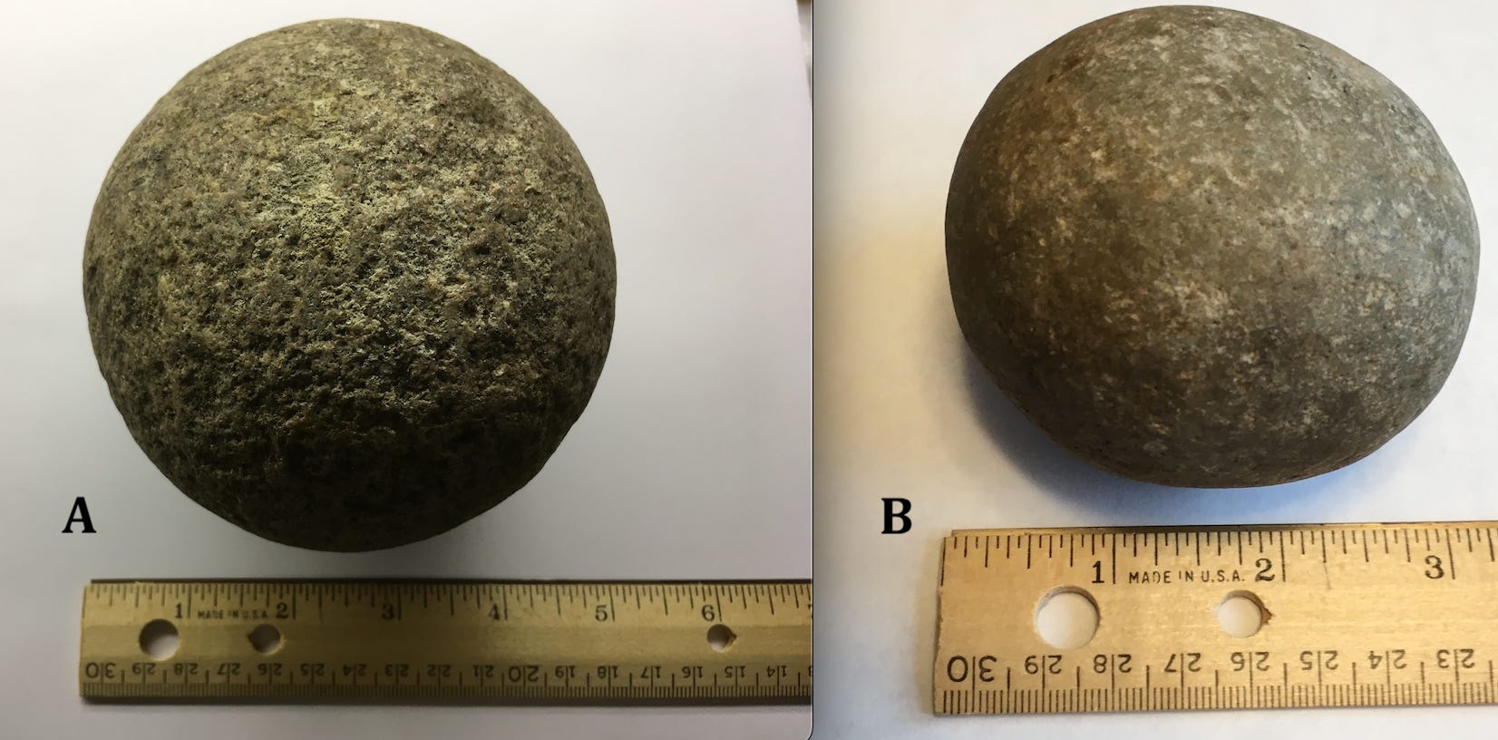
Figure 3----A. Spherical rock from Blood Run. (This artifact is displayed in the Lyon County History Museum in Rock Rapids, IA.) B. Spherical rock found on the family farm.
Collections from both Blood Run and the farm include an enigmatic artifact that is distinctive (Figure 3), but we don’t really know how it was used. It’s been suggested to be a hammer stone tool, a gaming piece, or a ceremonial object. If you’ve seen something like these spherical rocks or have an idea of how they may have been used, please let me know. Whatever their function was, they’re distinctive and unique and provide another way to tie the two locations to each other.
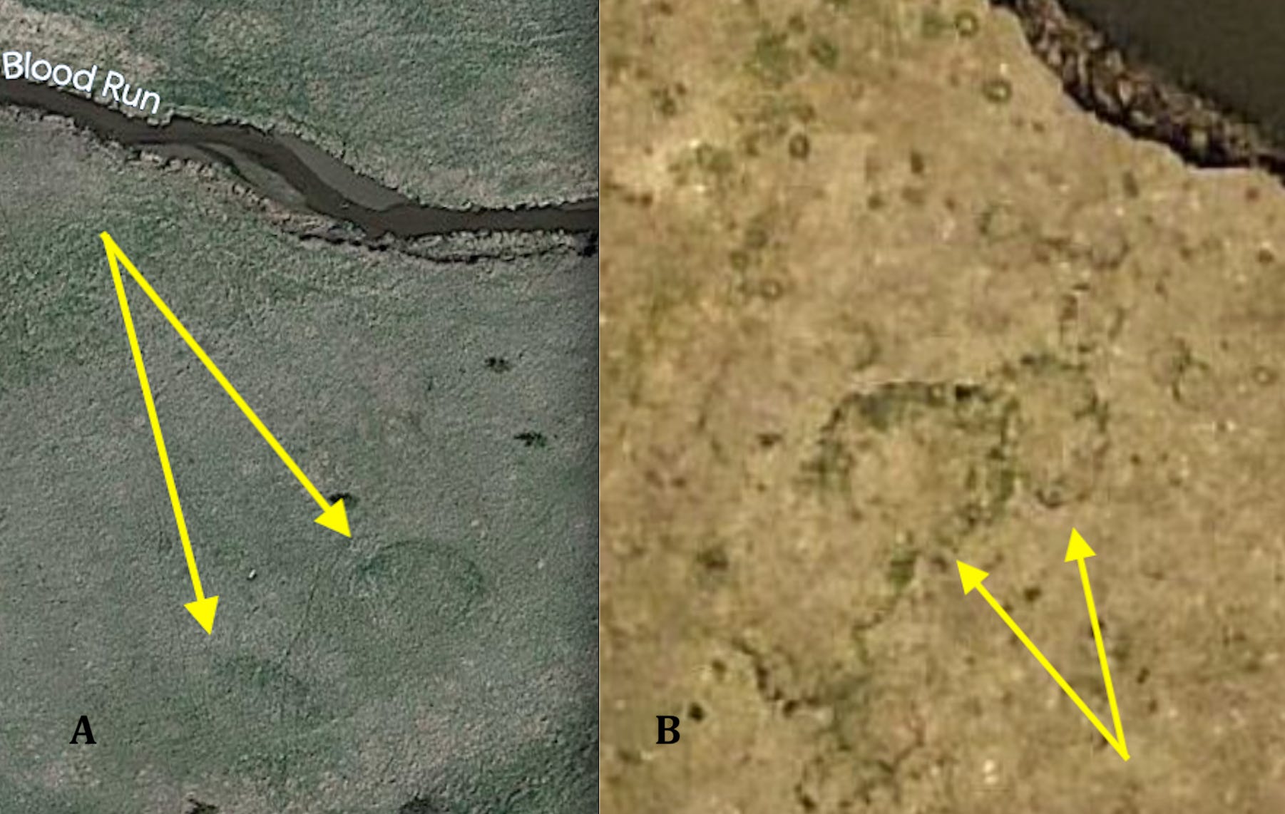
Figure 4---- A. Circular vegetation anomalies at Blood Run visible on Google Earth. B. Circular vegetation anomalies at Lone Tree Farm visible on high resolution air photos.
Artifacts aren’t the only things that Blood Run and Lone Tree Farm have in common. Both areas have circular vegetation anomalies visible on satellite images and air photos (Figure 4). It’s believed that at least some of these circles in the grass are related to specific archaeological features, although there may be other possible explanations for their origin. In contrast with the artifacts, these landscape components are not something that you can hold in your hand or dig up in an excavation. Consequently, their significance in standard archaeological interpretations may not be clear.
Landscape features like circular vegetation anomalies and linear trends to the southeast and northeast are more ambiguous than concrete artifacts. But, patterns in artifact distribution do tend to parallel landscape trends at Blood Run and the landscape trends do seem to have a significant message (see earlier posts on “Mapping Neighborhoods” and “Neighborhood Patterns”). The southeast and northeast landscape trends haven’t yet been clearly documented on the farm. But, archaeological work there is going on right now and the Land itself is helping to guide those efforts.
Apologies….
This is the fourth attempt to finish this post. The original plan was to write a short story about the neighborhoods in Blood Run. It would be a fictional recap to complete this “unit” with it’s previous three more technical posts.
However, a friend who read the short story suggested that I try again. On my second attempt I reverted and started another technical post. But then inspiration struck and I wrote a second short story that I sent out to three readers. Unfortunately, their feedback is slow and I’ve missed the “deadline” of one post every other week or so. One subscriber has even asked when this next post would come out, but kindly added “No Pressure”.
So, this is Version 4.0! It’s setting the stage for a shift to a four-post unit describing archaeology on the family farm located about 30 miles east of Blood Run. And, I’ll try to keep to the target of a couple of posts every month. Then we’ll come back to Blood Run to deal with erosion on the mounds and the attempts at protecting the site.
I do have goals and plans for this whole enterprise….they just don’t always work out in ways that I anticipate!
Fascinating. I only recently learned that Cornell University owns 51% interest in the Blue Hills Quarry, 12 counties in northern Wisconsin. I learned the Blue Hills Pipestone Quarry, a sacred site listed on the National Register of Historic Places in 2003 as the Wajiwan ji Mashkode Archaeological District, is another source of stone for sacred pipes. There is a professor St. Germaine at UW-Eau Claire who recently gave a talk about this there. I'm fascinated by the round features in both places.