


Naming the Farm
And other landmarks along the Rock River

Naming landmarks is often a political operation—sometimes subtle and other times overt. As we saw in the last post, the name for Blood Run Creek has no clear basis in local science or history. But, after reviewing a number of locations around the region that had a “Bloody Run Creek”, I speculated that maybe that name came west with the advancing settlers. Then it was modified and applied to the stream that’s a tributary to the Big Sioux River at Blood Run National Historic Landmark about thirty miles west of Lone Tree Farm.
Some Native American names have been retained and are still used today, although often in some modified form. That’s what has happened for a number of streams in Rock County, Minnesota, where the Farm is located. In this post we’re going to look at why the Farm is named “Lone Tree” and also take a tour of some names around Rock County.

Figure 1----A) Map by Nicollet 1838/9. B) Glacial streams as travel corridors.
In the late 1830s Joseph Nicollet, working for the US government, explored a region that included southwestern Minnesota. The map that he produced includes four streams labeled with Dakota names (Figure 1-A): Rock River, Chanarambie Creek, Champepadan Creek, and Kanaranzi Creek. He also provided translations: river of the stone hill, hidden wood river, thorny wood river, and river where the Kansas were killed.
These four streams host multi-component archaeological sites (Figure 1-B, A through D and 1 through 4) that can be interpreted as indications of Native American travel corridors. The stream valleys originally formed by erosion and deposition from meltwater off a glacial margin marked by the end moraine complex in the eastern part of the area. The three tributaries to the main stem of the Rock River provide easy access through the hills of the moraine complex and are arranged like rungs on a ladder from south to north. Lone Tree Farm is located on the southern-most rung at the green 1 in Figure 1-B.
I’m grateful to have a friend who is a Dakota scholar and speaker. He kindly provides insights that are otherwise not available for those of us who do not speak Dakota, which I regard as a language of the Land. He tells me that Nicollet’s translations for Chanarambie Creek and Champepadan Creek aren’t too bad. But, his translation for Rock River has a remarkable twist on some new changes just completed at Blue Mounds State Park located on the river. And, he confirmed (again!) the difficulties with the name Kanaranzi Creek.

Figure 2----Kanaranzi Creek on Lone Tree Farm. The two photos were taken from approximately the same location. A) 1970s by Jon Gilbert. B) 2010s by Robb Shurr.
Kanaranzi Creek has had reputation of being a highly meandering stream (Figure 2-A) but in the last few decades the channel has been modified into a more straight form (Figure 2-B). Hydrologists working for the state believe that this change is the result of a higher base flow resulting from more water in the watershed. The increased water volumes are probably due to recent increases in drainage tile installed in agricultural fields and possibly also due to climate change.
That meandering channel suggested to early homesteaders that the translation of Kanaranzi should be “runs as the crazy man walks”. At least that’s what my grandmother told me. However, I’ve also heard a reference to “crazy woman creek” in the area. That probably wasn’t my grandmother, although it might have her mother-in-law (my great-grandmother) who was a driving force in local affairs, like establishing churches! However, neither of those references to mental health challenges hold up in the “official” translation on Nicollet’s map: “river where the Kansas were killed”. The Kansas or Kansa Nation was located very much farther south and historians (Bray and Bray, 1993) question the possibility of a battle this far north. In addition, there’s probably been an English and/or French modification of the original Dakota word. Although there’s no clear resolution about the exact origin of the name Kanaranzi Creek, a contemporary Dakota rendering of “river where the Kansas were killed” is: Kanza Wicaktepi Wakpa.

Figure 3---The huge cottonwood that gave Lone Tree Farm it’s name. A) View from the north. B) View from the west.
There is, however, no confusion about how Lone Tree Farm got its name. There was a huge cottonwood tree located near the homesteader’s dugout in 1871. By 1925 it was completely dead and blew down, so the photos in Figure 3 must have taken sometime before that. The local newspaper had several stories about the “old Lone Tree” that fit into the myth of “Manifest Destiny”. The editor called it the “monarch of the prairie” because it was big and stood relatively alone on the open prairie. One of the stories said that it marked the boundary between Indian territories and another claimed that it was a marker of the state line between Minnesota and Iowa. And still another story played into the preoccupation with blood and battles.
Supposedly, three trappers were attacked by Indians and one of them was killed and buried beneath the tree. In addition, there was a treasure! The trappers had sold their pelts and buried the money under the tree at the time of the fight. However, my brother and I spent a lot of time looking for the treasure when we were growing up along the creek and we never found anything. We were the fourth generation of kids searching for the “trappers treasure” and there have been a couple more generations of treasure hunters since then. Also, the story never explains why the survivors didn’t just dig up the money and continue on their way after the attack. It does, however, follow the widely-accepted narrative of Manifest Destiny.
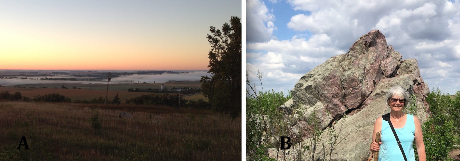
Figure 4---- Blue Mounds State Park. A) View to the south from Eagle Rock Vista showing fog along the Rock River. B) Margaret Shurr at Eagle Rock on a day in high summer.
In the past couple of years, the Minnesota Department of Natural Resources has opened a new component to the Blue Mounds State Park (labeled as “The Rock” on Figure 1-A). The Eagle Rock Vista emphasizes the southern part of the park that gives an impressive view of the landscape (Figure 4-A) that was once open tall grass prairie and now is mostly row-crop farming and the municipality of Luverne. I’ve heard a story that the hill or “mound” of red Sioux Quartzite was named “Blue Mound” because that’s the color that it had from a distance. It’s only been the last few years that the single large boulder of Sioux Quartzite known as Eagle Rock (Figure 4-B) has been elevated to a formal, named feature. That isolated boulder rests on the hilltop that’s covered with extensive bedrock exposures.
I’ve always thought of “The Rock” as the total hill of bedrock, rather than a single boulder. However, a contemporary translation of the Dakota words used by Nicollet changes the meaning from the whole mound to a rock resting on a hilltop. That means the river is not named for the total mound of bedrock, but for the isolated boulder on top of the hill. The new Eagle Rock Vista conforms with the meaning in the original Dakota language. I wonder of the State got guidance and input from tribal consultation?
The name on a township to the northeast of park brings us back to the notion that a preoccupation with “Manifest Destiny” tends to emphasize battles and blood. Remember that Blood Run might have provided the “click bait” that sold newspapers and gave some notoriety to that area. In a similar way, a name like “Battle Plain” would tend to draw attention to a newly-organized township trying to attract settlers. There was no longer a “threat” because an early history of the county (Rose, 1911) reported that the battle was between Dakota and Ponca people long before white settlers were busy naming townships and landmarks. But, the political complications associated with Manifest Destiny required that things had improved on the prairie after the “brutal” battles at places like Battle Plain and the river where the Kansa were killed (aka, Kanaranzi Creek).
Thanks to Avery Jones for his help with language and landscape and for reading an earlier version of this essay. He is a keeper of traditional Dakota knowledge, a linguist and scholar, an artist and writer and a member of Wakpa Ipaksan Dakota Wicoti, Bend in the River Dakota Community (Flandreau Santee Sioux Tribe). Thanks also to Jon Gilbert, Robb Shurr, and Margaret Shurr for help with photographs.
Happy Easter to you and to your family, friends, and extended community.
The history of these place names was interesting. How helpful to have a Dakota collaborator to make the important discovery about The Rock. And it is interesting to contemplate the Lone Tree as a nod to Manifest Destiny. Fascinating essay.