


Protecting the Bridge Site
Cultural Resource Management on Kanaranzi Creek

In the last post we looked at how the bridge on the Stateline survived the 2024 flood event and the implications for a nearby archaeological site. In this post we’ll describe that Bridge Site in a little more detail and discuss how cultural resources may help to provide protection.

Figure 1----Photos of the Stateline Bridge during the past decade. A) Measuring the stream flow during flood conditions. B) Flooding associated with a normal spring flood.
The flow conditions are characterized in terms of cubic feet per second (cfs); flood levels are tied to how much water is moving through a standard cross-sectional area. After the new bridge was built more than a decade ago, the United States Geological Survey (USGS) periodically measured the flow conditions from the bridge deck (Figure 1-A). You can see the orange pontoons that support the instruments just to the left at the end of the rope held by the field technician. The data are used to help calibrate models that estimate flood levels downstream. During normal spring melt and runoff, the bridge design worked as advertised (Figure 1-B). The infrastructure is protected because the high water crosses the road and the bridge approaches rather than overtopping the bridge deck. The flooded archaeological Bridge Site that might be used to repair washed out approaches is shown by the arrow in Figure 1-B.
The flow in cubic feet per second at Rock Rapids, IA, was used to predict the timing and maximum flood level as we saw in the previous post. Do you remember hearing about 50-year and 100-year floods? That’s the way insurance rates are calculated because it tells how often a flood of a specific severity will occur. I went looking through the media coverage of the 2024 flood to see how it compared with those standard levels, but I haven’t seen any mention of 50-year or 100-year floods. Maybe they’re not an important thing anymore because the flooding frequency has been changing so much?
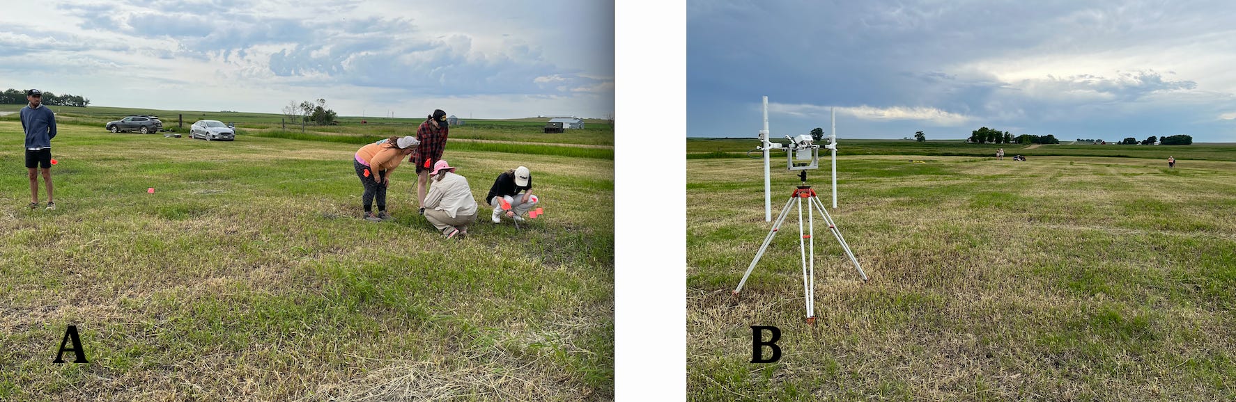
Figure 2----Activities of the Field School during the summer of 2024. A) Laying out the grid for geophysical measurements. B) The instrument used to make the make measurements is called a “gradiometer”.
Ironically, just one week before the 2024 flood, there were archaeologists at work on the Bridge Site. Augustana University in Sioux Falls, SD, is conducting a Field School in Cultural Resource Management (CRM) on Lone Tree Farm. As a part of that training, the students assisted in a survey that measured the changes in soil magnetic properties. The orange flags mark a grid used to make the measurements (Figure 2-A) and the instrument is “parked” on its stand as they finish the grid (Figure 2-B). I’ll show you the results later in this post. For now, you should know that CRM studies are usually done before major construction projects to determine if there are any archaeological materials, aka “cultural resources”, that might be at risk. Geophysical surveys like this are “noninvasive” because they give an image of what’s below the ground surface without digging into and disturbing possible archaeological features.
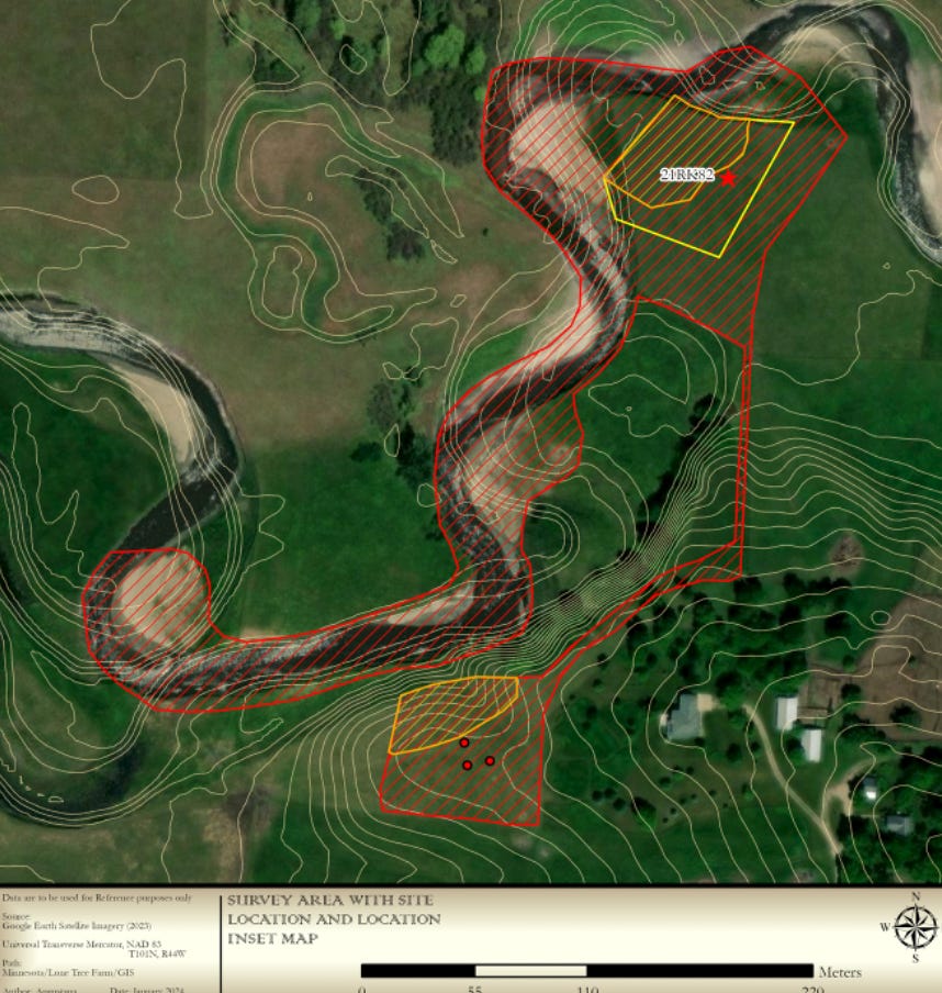
Figure 3---- Location of activities of the Augustana Archaeological Lab personnel in the fall of 2023 (Wiebelhaus and Johnson, in preparation).
It’s important to not disturb features at the Bridge Site because Native American Elders have determined that it may be a ceremonial site. The Augustana Archaeological Lab brought the Elders out to the farm last fall when the first preliminary fieldwork was being done. The archaeologists surveyed the area shown with red lines (Figure 3) and then did an excavation at the red star and smaller “shovel tests” at the red dots. However, before any of that digging began, the Elders looked at the area and determined that the places shown with orange lines should be avoided. They also visited the Bridge site.

Figure 4----Locations of the areas that Native American Elders identified as significant shown as orange circles and the relative locations of 21RK82 and the Bridge Site.
Figure 4 shows the relative locations of the places that the Elders were concerned about. The orange circles approximately correspond to the orange areas in Figure 3. The black circles are labeled with formal site numbers assigned by the State of Minnesota. 21RK 82 is where the excavation and ground survey were done last fall. 21RK19 is a separate archaeological site that has been partially removed by erosion of the Creek banks. And the Bridge Site is where the geophysical survey (see Figure 2) was carried out during the Field School several weeks ago before the flood. The Native American Elders believe that the area of the orange circle at the Bridge Site is a possible ceremonial ground. That area is included in the noninvasive geophysical survey.
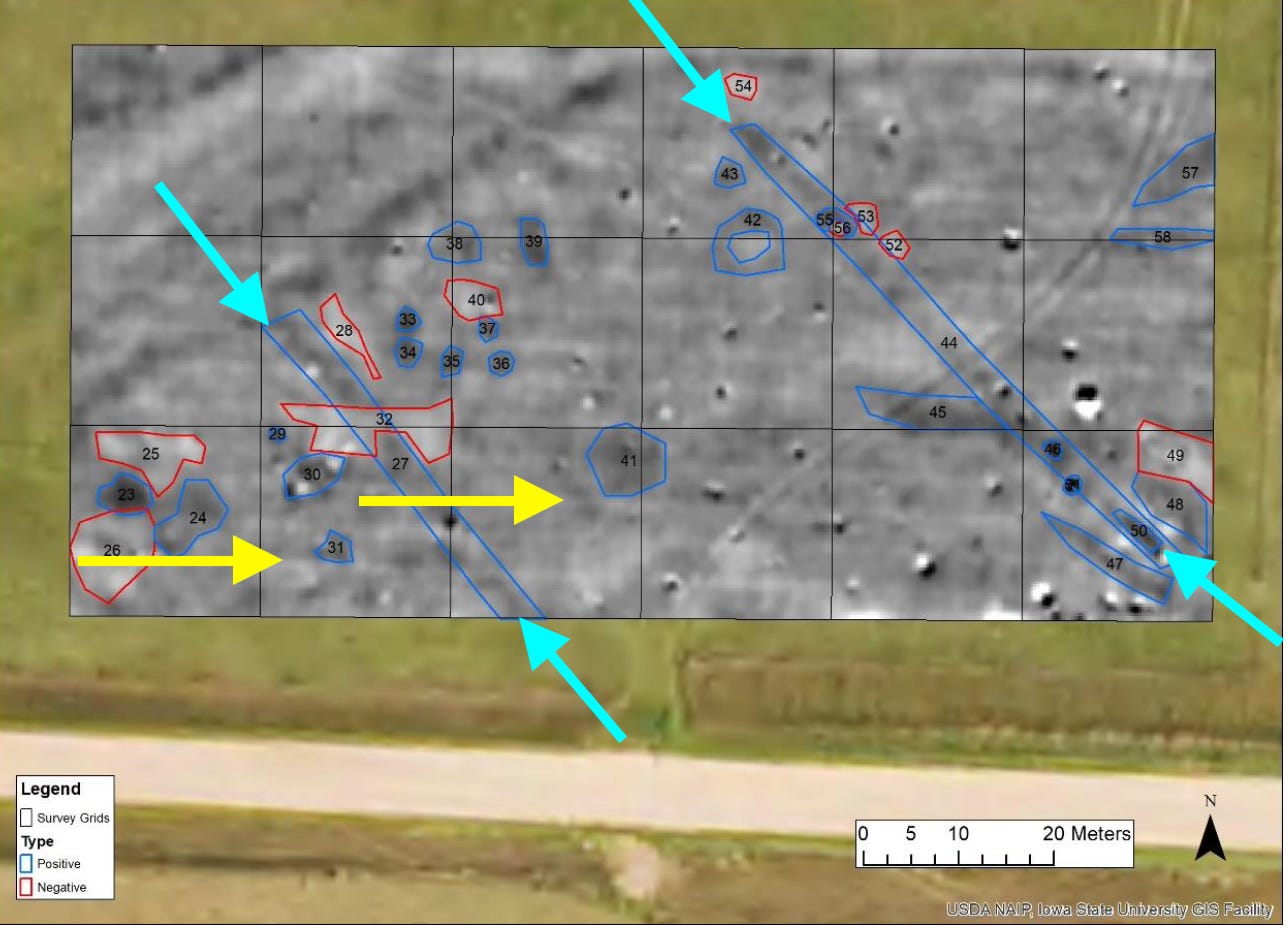
Figure 5----Results of the gradiometer survey with anomalies that may be the result of Native American activities marked in blue and red (Betts, 2024). Yellow and blue arrows are explained in the text.
After the gradiometer measurements were taken in the gridded area (Figure 2), the data were digitally processed to produce an image that displayed the information (Figure 5). There are 58 anomalies that looked significant and 22 of those are interpreted to be caused by natural forces and/or “post contact” cultural activity by settlers. For example, the faint pale white lines marked with yellow arrows are most likely east-west plow furrows. On the other hand, the remaining 36 anomalies are probably features associated with Native American activities. There are lots of circles and irregular-shaped “blobs” that need to be investigated in more detail to get a better idea of what they are. But, there are also two distinctive lines, actually narrow linear zones, marked with light blue arrows. A Native American who is a traditional knowledge keeper pointed out several patterns that may have cultural significance, but he was particularly interested in the linear zones marked by light blue arrows. Although he didn’t speculate how the zones might relate to the possible ceremonial grounds, he did draw attention to the small internal circles inside of the narrow, linear zones.
The linear zone has expression in another type of data. LiDAR is detailed elevation information based on a laser survey from an airplane. Earlier this year we had a consultant prepare a detailed topographic map of the Bridge Site using LiDAR data. The eastern linear feature in Figure 5 also shows up on that topographic map, although not as a simple linear mound. Linear mounds along the Des Moines River in Iowa are described in a recent publication (Whittaker, 2024). The average length for more than 140 linear mounds is about 40 m (~130 ft) and most are 5 to 7 m (16-23 ft) wide. That’s similar to the two linear features (Figure 5) at the Bridge Site: both are about 5 m (16 ft) wide; the east zone is 65 m (213 ft) long and the west zone is 45 m (148 ft) long. The linear mounds in Iowa are generally less than 25 cm (10 in) high. But, the linear zones at the Bridge Sites may have been plowed down because there is evidence for that in the faint east-west lines in the gradiometer map (Figure 5).
This is probably WAY more detail than you care about, but there’s an additional thing that ties the linear zones at the Bridge Site to the linear mounds in Iowa. Although there’s no direct information on when the Iowa linear mounds were built, they are co-located with archaeological sites associated with the Great Oasis culture (Whittaker, 2024). On the farm at 21RK82 (Figure 4), two pieces of pottery have been identified as Great Oasis style and a radiocarbon date of 1256 AD from a bison skull falls at approximately the end of the period, 900 to 1250 AD) generally recognized as the time when Great Oasis culture thrived (Johnson, 2023).
So, the archaeological investigations that started with consultation with tribal heritage preservation officers last fall have now reached a point where a traditional knowledge keeper believes that there are specific features at the Bridge Site that have cultural significance. And the archaeology seems to support that idea! The next step is to see if the flood has exposed any more useful artifacts or bones and then put the relevant information into an application for assigning a formal archaeological site number to the Bridge Site. That’s one concrete way that the work done by Augustana’s Archaeological Lab and the Field School in Cultural Resource Management can provide some protection for the Bridge Site.
ACKNOWLEDGEMNTS :
Thanks to Dr. Phyllis Johnson for reading an earlier version of this post. She’s the Director of the Archaeology Lab at Augustana University and is teaching the Field School.
As always, the publications cited in this essay are only listed by author and date. If you want a complete reference, please contact me.
A NEW SUBSTACK: The Portal to the Gray Blade.
On July 4, I launched a new Substack that’s total fiction but is set in the Land at the Edge of the Sky. The new “publication” is a time-travel fantasy that deals with themes pertinent to what’s going on around us right now. Two or three chapters will come out every week between now and November 5, 2025, and if you subscribe they’ll be emailed directly to you with no charge. Alternatively, you can use this current blog to get access to the new chapters because I’ll provide a link whenever there’s a new post on this Land at the Edge of the Sky Substack.
Here's the link to the first three chapters of The Portal to the Gray Blade.
Thanks, Jill. I didn't get my comment written on your last post....looks like you've uncovered an interesting mystery!
The maps are interesting to study and compare. I look forward to learning more about what the creek tells us about the past.