


Features and Sites on the Farm
Circles and Lines

In the last several posts we’ve been looking at two distinctive artifacts from Lone Tree Farm in some detail (maybe excruciating detail?!). In general, you can hold artifacts and pieces of bison bone in your hands or put them in your pocket and carry them off to show the grandkids. However, there are larger things anchored in the Land that have just as much archaeological significance….maybe even more.
Artifacts are usually found in clumps on the surface of the ground and those collections often mark underground concentrations that may be a fire hearth, a cache/storage pit, the remains of a dwelling, or even a mound or some other constructed earth works. Those “features” are in turn found in groups that constitute archaeological “sites”. So, the small artifacts are arranged into larger features that are found gathered together into still larger sites. In the past, it usually took excavation to document features and sites. But, now there’s a whole new set of tools that can be used without digging and destroying the record. Features have expressions as circles and lines in these new data sets and sites are distributed through the landscape in systematic ways. The new tools are useful in describing both features and sites.
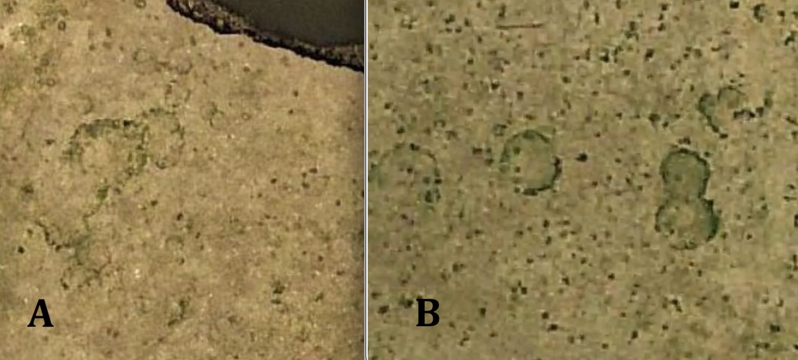
Figure 1----Circular vegetation anomalies in the Farm pasture. A) Site 21RK 82 that has lots of bison bones and artifacts. B) Bridge Site, as yet unnumbered, with fewer artifacts.
High resolution aerial photographs are probably the most accessible and easily understood of the new tools. There are two places on the Farm where air photos show circular features in the grass. One is Site 21RK82 (Figure 1-A) where there are numerous bison bones and artifacts, including the blades that we’ve been discussing in the last couple of posts. And the second location is the Bridge Site (Figure 5-B) where, after visiting the site, traditional knowledge keepers suggested that it may have hosted ceremonial activities.
At both sites the circles have expression in the grass as differences in vigor and color and also as possible differences in species. They are more clearly visible during different seasons of the year and also in years with unaverage rainfall. However even with the varying conditions, the circles have been recognized by multiple observers, sometimes with only a casual inspection. So, you can see these things on the ground when you’re standing next to them and you can see them on detailed aerial photos, but they also show up on satellite images available from Google Earth. And, the circles can also be documented on maps and images based on other high tech data sets.

Figure 2----Image of magnetic gradiometer data at Site 21RK82 with interpretations of probable archaeological features (Messerole, 2020).
Measurements of differences in soil magnetic properties can be integrated to produce an image (Figure 2) that reflects specific archaeological features. The group of circles in the upper right corner has been interpreted as a dwelling with associated cache pits; another archaeologist familiar with the signatures of plowed-down mounds confirmed the idea of a dwelling. The open red triangles are believed to be fire hearths and the solid red triangles are pieces of post-settlement metal. The middle yellow arrow points to other circular patterns in the magnetic data that do not show on the air photos, but may mark additional features. The lower yellow arrow points toward two possible hearths where some excavation has been initiated. Traditional knowledge keepers advised limiting excavations to this area and avoiding the more extensive concentration of features in the upper left corner of the map.
In addition to the circular features, there is a distinctive line that runs through the middle of the map. We’re not sure exactly what kind of archaeological feature this might be, but it is similar to lines seen at the Bridge Site on the Farm. Circles along the red line drawn by the archaeologist who collected the data seem to help define a zone marked by the yellow dashed line that I added. This zone is about 15 feet wide, 150 feet long, and trends to the southeast at 155 degrees east of north (N 155 E). (Please note, the image is not oriented with north to the top so the southeast trend appears to be to the southwest.) These measurement details are useful to compare with linear features at other archaeological sites.
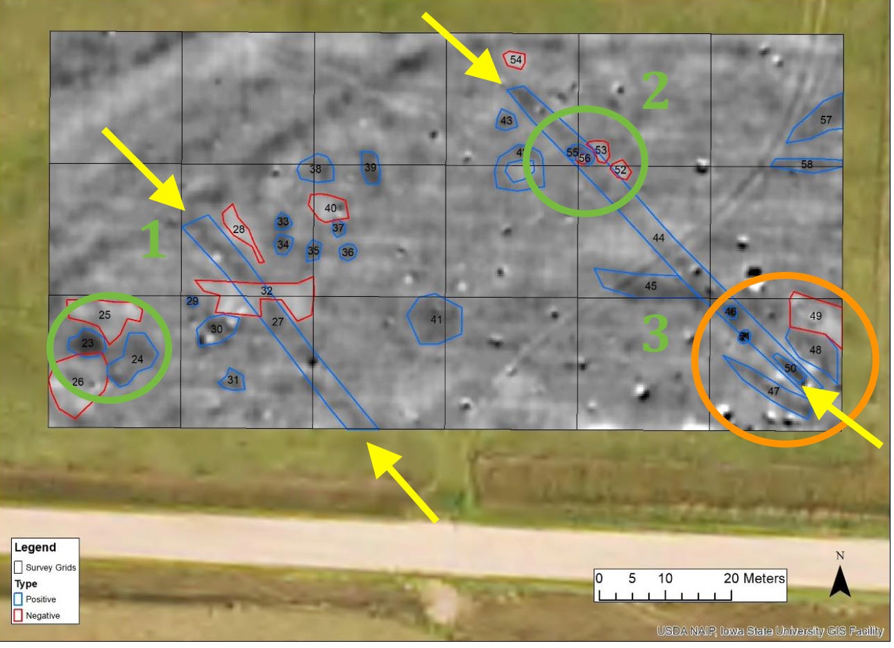
Figure 3---- Image of magnetic gradiometer data with probable archaeological features at the Bridge Site located about a quarter mile downstream from 21RK82 (Betts, 2024).
The Bridge Site has not yet been assigned a formal Smithsonian Number, but traditional knowledge keepers have told us that the circles seen on the air photos (Figure 1-B) were most likely an area where ceremonies were held (orange circle, Figure 3). However, the circles visible on the air photos and in the vegetation on the ground don’t show up in the gradiometer mapping. Instead, there are numerous small circular anomalies (marked with blue lines interpreted by the archaeologist who collected the data and produced the image) located all over the map. So, there are circular features here, but the really consequential features are the two linear zones indicated with yellow arrows.
These two linear zones are similar to that seen at 21RK82 and they have similar attributes. The east zone on the right is about 15 feet wide, 200 feet long, and trends southeast at N135E. The west zone on the left is also about 15 feet wide, 150 feet long, and trends southeast at N140E. During the Field School this past summer, two “shovel tests” were done at locations 1 and 2 marked by the green circles. Both tests produced small “micro” artifacts, including a probable tiny piece of pottery. No tests were done near ceremonial area (green 3, Figure 3). All of the numbered anomalies in Figure 3 are believed to “have no obvious natural or post-contact cultural origins” (Betts, 2024). In other words, these numerous features are probably the result of Native American activities and the shovel tests seem to confirm that.
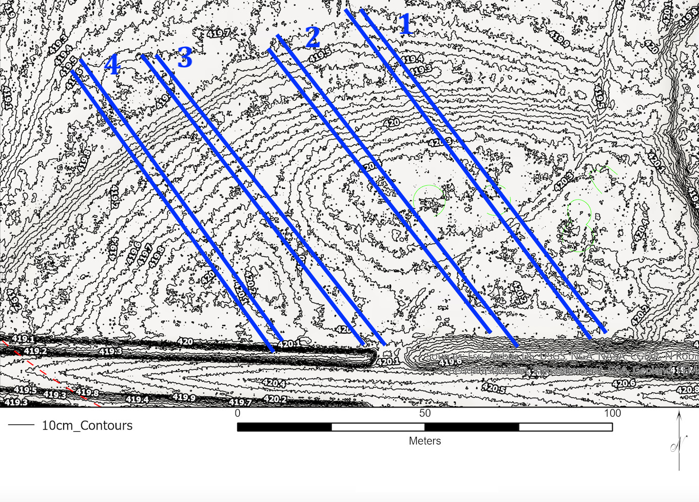
Figure 4----Detailed elevation map showing vertical differences of about 4 inches. Prepared from LiDAR data in the public domain by staff at the Archaeological Research Center (ARC) of the South Dakota Historical Society. The four linear features shown in blue were identified by George Shurr after helpful initial suggestions by ARC staff (Anton, 2024).
Topographic maps show lines of equal elevation that describe high areas and low areas on the earth’s surface. Conventional, “old school” topographic maps usually use contour lines separated by 5 or 10 vertical feet and are based largely on on-the-ground surveys. But, new air-born surveys (called LiDAR) are available using lasers to measure vertical differences of just a few inches. The resulting images document “micro” highs and lows that are so subtle that you might walk right over the small “hills” and “valleys” and not even see them.
Detailed topographic mapping at the Bridge Site (Figure 4) reveals four linear features that trend southeast (N145E) and are about 10 feet wide. The lengths vary from 350 feet on the east (blue 1 on Figure 4) to about 250 feet on the west (blue 4 on Figure 4), although those varying lengths may result from truncation by the roadway along the south side. Linear features 1 and 3 almost correspond with the two linear features visible on the gradiometer image (Figure 3). Linear features 1 and 2 seem to mark local high spots but line features 3 and 4 seem to be associated with local low places.

Figure 5----High resolution areal photographs of southeast-trending linear features at the Bridge Site. A) March, 2022. B) May, 2008.
The linear features that have expression in the magnetic gradiometer data (Figure 3) and on the detailed elevation map based on LiDAR (Figure 4), can also be seen on high resolution air photos. Although they are subtle, the lines are designated with yellow arrows on the photo from end of winter (Figure 5-A) and from late spring (Figure 5-B). Note the remains of winter snow and the curved field-access road in the newer brown photo and the lack of the curved road and the cattle trails toward the top of the older green photo. We need to have geographic information systems (GIS) work done to clearly demonstrate that the lines on the magnetic and elevation images correspond with each other and with the lines on the air photos.
The dimensions of the zones at the Bridge Site and at 21RK82 are similar to those described for linear mound features in the Des Moines River valley of central Iowa (Whittaker, 2024). Those linear mounds are near a number of sites associated with the Great Oasis culture and that’s one of the archaeological components found on the Farm. In addition, linear mounds in Hidatsa villages in North Dakota are generally about the same size and are made of fill that contains finely-broken refuse (Ahler and others, 1991). Linear mounds in both Iowa and North Dakota are less than 1 foot high and the micro-topography at the Bridge Site also has local relief (AKA differences in elevation) of about 4 to 8 inches. In addition, the small piece of pottery found in one of the shovel tests might qualify as “finely-broken refuse”. However, archaeologists aren’t certain why the linear mounds were built. We need to have input again from the traditional knowledge keepers; you’ll recall that they originally identified the Bridge Site as a possible ceremonial area. That’s the main reason that we’ve put so much effort into the site.

Figure 6----The pasture at Lone Tree Farm with the locations of archaeological sites, springs, and areas visited by traditional knowledge keepers.
In a general way, the sites on the Farm line up along a northeast trend (Figure 6). Eventually, we’re going to see that the northeast trend and the trends to the southeast in the linear features also have significance at Blood Run. We’re also going to talk about naturally-occurring springs at both Blood Run and the Farm because springs are generally important for Native Americans. There are at least eight springs in the Farm pasture (Figure 6). Four are located at the high banks along the Creek channel and four are at the edge of the floodplain near the margins of the upland surface. The orange ovals (Figure 6) show the areas where traditional knowledge keepers have visited. We plan to keep engaging with them because they have unique perspectives that help us to understand what the Land and the Creek are trying to tell us.
NEW YEAR LOGISTICS:
One of our Christmas notes included a question from a long-time friend about the origin of names like Blood Run and Kanaranzi. I’ve been thinking about doing a post about that, so I’ll definitely get the job done now. Another friend recently surfed through a number of the posts in the Archive and “Liked” a bunch of them. That helps me know what’s most interesting for you folks.
SubStack is a platform that facilitates feedback and interaction between the author and readers. If you really enjoyed a particular post, please “Like” it using the heart icon near the top or bottom of the post. If you’ve got a suggestion or a question, please write it as a “Comment”. When you click on the post title, you’ll go to the home page and if you know someone who might be interested in a specific post, please use the “Share” button. And if you want to check out an old post, please use the “Archive” that’s available if you the click on”Rooted--Land at the Edge of the Sky”. Navigating this stuff is a little complicated, but it helps a lot when you use those opportunities to Like, Comment, Share, and explore the Archive. Thanks for reading these posts!
As always, there’s usually not a formal list of references cited in a post. But, it you want details on the publications, you can always contact me.
It is so interesting to read the results of this archaeological research on your family farm. That this may have been a ceremonial site makes it even more compelling.