


Blood Run as an Ancient Campsite
Technically Called a Multi-component Area

It’s been a busy, wet summer. Lately, most of the articles posted in this “blog” have been about Field School and flooding at the Farm. But, now we’re headed back to the Blood Run National Historic Landmark (NHL) located on the Big Sioux River about 30 miles west of the Farm.
This new series starts with a look at the Blood Run area as a possible ancient campsite that’s been used for many hundreds of years. In archaeology jargon it would be called a “multi-component” site occupied by a variety of cultural groups.
I’ve already talked about some aspects of an ancient campsite/multi-component site back on Lone Tree Farm. You can find those articles here and here.

Figure 1----Areal view of the main mound group at Blood Run NHL. This photo taken by Jim Zangger appeared on the 2022 calendar put out by the Friends of Blood Run. One expert on the site says that this is the best shot that he’s ever seen of the iconic mounds.
Although we’re going to be looking at less familiar aspects of the area, it is the extensive record of the Oneota cultural group that makes the Blood Run NHL most significant. A new publication (Henning, 2023) summarizes how Blood Run is unique among other Oneota sites: dwellings and mounds are intermingled on both sides of the river in this largest known Oneota site where pipestone trade items were created and dispersed throughout a widespread network. This activity took place from about 1500 AD to 1700 AD. A description of the archaeology at Blood Run was published in 2004 (edited by Henning and Thiessen) and it remains as the most extensive compilation to date.
Regardless of the importance of the NHL (maybe because of it?), there has been a complex history of attempts to protect the significant cultural resources. That history is included in a recent newspaper article available here. Back before the turn of the century (that is, prior to 2000!) there was an attempt by local citizens in Lyon County, IA, to organize and promote a national park that would include both sides of the Big Sioux River. That effort stalled and the designation of “National Historic Landmark” was awarded as sort of a “consolation prize”. Fast forward to 2013 when a $2.0 million state appropriation was made on the Iowa side at about the same time as Good Earth State Park was established on the South Dakota side. However, things stalled again and the Iowa appropriation had “disappeared” by 2021. I’m not exactly certain about the dates and dollars; they come from the newspaper article. Long story short, the majority of the mounds in the main group shown in Figure 1 still do not have the formal protection that would be provided by government ownership of the land.
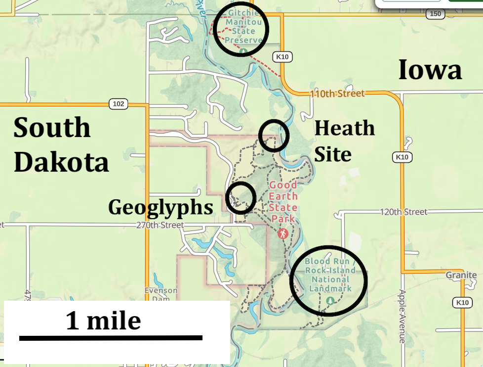
Figure 2----Four archaeological sites located along a stretch of the Big Sioux River that’s about 1.5 miles long.
But, Blood Run is not the only important archaeological site located along the Big Sioux River (Figure 2). On the South Dakota side, geoglyphs and the Heath Site are both found within the boundaries of Good Earth State Park. Back across the river and just to the north, Gitchie Manitou State Preserve is situated on the Iowa side. That makes four sites within about 1.5 miles. The cultural resources at the four sites seem to date from four separate times and we’ll look more closely at each of them. But, this does appear to be a multi-component area comparable to Lone Tree Farm where there were also multiple cultures from a range of dates distributed along less than 1 mile of Kanaranzi Creek.
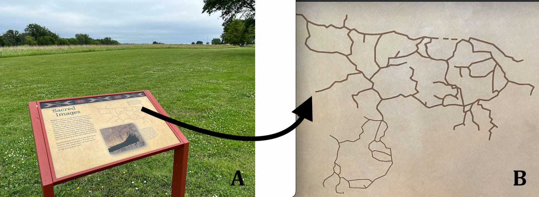
Figure 3----Geoglyphs in Good Earth State Park. A) Marker just east of the Visiter’s Center. B) Representation of the bison figure now covered by the mowed grass in Figure 3-A.
The original location planned for the Visitor’s Center at Good Earth had to be shifted because initial construction activities exposed a unique set of archaeological features called “geoglyphs”. You can read about them on the marker that’s currently outside of the Visitor’s Center (Figure 3-A). Basically, these features are artistic representations of a number of animals including the bison shown in Figure 3-B. The same outline is also a pattern in the carpet inside the Visitor’s Center. The animal figures were created by digging narrow trenches and filling them with dark-colored soil that set the outlines apart from the background. Radiocarbon dates from the material filling the trenches go back to around 50 BC to 500 AD and so are much older than the Oneota occupation of the area.
Similar geoglyphs in western Iowa have been interpreted (Benn, 2018) to be “cosmograms” which are symbolic representations of specific aspects of belief systems (Sundstrom, 2012). In other words, these are sacred sites probably associated with religious ceremonies or rituals. The geoglyphs in western Iowa are also located on high hill tops above a wide river valley. So, that’s essentially the same location in the landscape as the geoglyphs here at Good Earth. And, the geoglyphs suggest that Good Earth State Park was a locality that had religious significance for the people that lived here about 2,000 years ago.
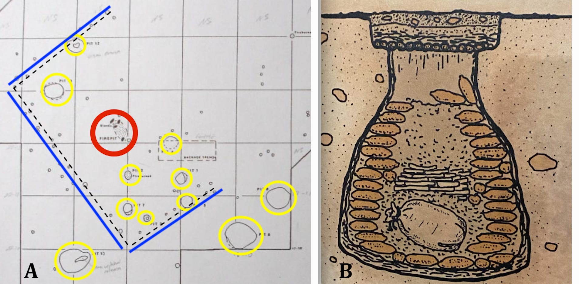
Figure 4----A) Sketch of some of the features excavated at the Heath Site (modified from Tomcek, 2010). B) Illustration of the side view of a cache pit used for food storage.
To the north of the Visitor’s Center and down the hill toward the river there’s an archaeological site that has pottery associated with the Great Oasis cultural group. Excavations have documented post holes that outline a possible lodge shown by the dashed and blue lines in Figure 4-A. In addition to a fire hearth (red circle), there are eight small cache pits (yellow circles) within the lodge outline. The three larger cache pits located outside of the lodge seem to have been used to dispose of refuse like parts of butchered bison. The smaller pits inside the lodge may have stored corn and other food stuffs. The cache pit illustrated in Figure 4-B is from the Oneota displays in the Visitor’s Center, but most likely also is representative of how the Great Oasis cultural group stored corn.
The Great Oasis has been called a transitional group and the artifacts are associated with a fairly wide spread of dates around the region. Radiocarbon dates from the Heath Site are about 400 to 550 AD (Tomcek, 2010). Although that’s generally older than Great Oasis dates in other areas, which usually are in the range of 900 to 1100 AD, the Heath Site dates are similar to those associated with the geoglyphs located just up the hill at the Visitor’s Center. Some of the apparent differences between the regional Great Oasis dates and those at the Heath Site may soon be resolved because material from the site has recently been re-sampled. The results have not yet been reported.

Figure 5----Gitchie Manitou State Preserve. A) Map showing two mound alignments that point to opposite ends of the bedrock exposure (modified from Artz, 2014). B) Circles in the Sioux Quartzite bedrock are not thought to be made by humans (Shurr and Black, 2021).
The Gitchie Manitou State Preserve has outcrops of Sioux Quartzite that are the southern-most exposures of the hard pink rock that also is found all over Falls Park in Sioux Falls, SD. This same rock unit hosts the pipestone quarried at Pipestone, MN, and crafted into trade items at Blood Run. The Sioux Quartzite is labeled as “Precambrian Outcrops” in Figure 5-A. The bedrock here also has some enigmatic circles (Figure 5-B) that geologists have no clear explanation for (Shurr and Black, 2021). This unique geologic locality may also have archaeological significance because two lines of mounds appear to point to the ends of the bare bedrock exposure that is marked with these mysterious circles that probably were not made by humans (Figure 5-A).
There was a controversy about the origin of the aligned mounds because some local citizens believed that they were not built by Native Americans, but were made by WPA workers in the 1930s (Whittaker and Alex, 2015). However, a geoarchaeological study (Artz, 2014) unequivocally demonstrated that the mounds were much older. This was based in part by comparing the cored soil layers inside the mounds with the layers in cores from the surrounding area. But, the real “clincher” was a small artifact recovered from one of the cores. It was made of Knife River Flint which is common in Middle Woodland sites throughout the Midwest. The Middle Woodland is generally-accepted (for example, by the National Park Service) to be from about 200 BC to 500 AD. That means that these mounds are in approximately the same age range as the geoglyphs and the Heath Site across the river in Good Earth State Park.
There is also a controversy around a tragic crime committed in Gitchie Manitou in the early 1970s. The incident has become sensationalized with the publication of several books so there’s still a shadow that lingers over the place. It has been suggested that the preserve should be ceremonially re-dedicated in order to move beyond the “haunted” reputation and emphasize the healing that has taken place. But, this is all relatively modern history when compared with the records of the “ancient campsites”.
I have to admit, when I started putting this essay together I was aware that the four sites we’ve looked at did not generally have the same radiocarbon dates. But, it turns out that the geoglyphs and the Heath Site both date back to around 400-500 AD and that’s within the range of the Middle Woodland assignment made for the mounds at Gitchie Manitou. So, it is possible that that people of one cultural group were active in all three sites. However, that was about 1,000 years before the people of the Oneota tradition built the mounds at Blood Run. The roots of Native American activity along this stretch of the Big Sioux extend very far back into deep time.
A NOTE ON REFERENCES:
There are a number of publications cited in this current post, but there’s not a formal list compiled. If you’d like to know the details about a specific publication, please send me an email and I’ll get a complete citation to you.
AN EVENT AT GOOD EARTH STATE PARK:
On September 14 there’s an event called Indigenous Artists of the Plains scheduled for Good Earth. There are details here. Be sure to check out the Visiter’s Center film and displays if you’ve never been there before. And, maybe hike down the trails to one of the overlooks to see the Blood Run NHL across the Big Sioux River in Iowa.

GRAY BLADE
On July 4, I launched a new Substack that’s total fiction but is set in the Land at the Edge of the Sky. The new “publication” is a time-travel fantasy that deals with themes pertinent to what’s going on around us right now. Two or three chapters will come out every week between now and November 5, 2024, and if you subscribe they’ll be emailed directly to you with no charge. Alternatively, you can use this current blog to get access to the new chapters.
The sequence of released chapters start here.
Here are the links for the most recent chapters of the free time-travel fantasy called THE PORTAL TO THE GRAY BLADE:
Chapters 20 and 21 are here.
Chapters 22, 23, and 24 are here.
Fascinating to read about the geoglyphs and the results of the dating of these materials. And I'd known nothing about the murders in 1973 in that area until you mentioned it.