


The Flood and the Field School
The Creek Says Don’t Worry : The Bridge Site Has Cultural Significance

It’s been several weeks since the epic flood of 2024 and the Augustana Archaeology Field School also ended a week ago. So, during that last week of Field School, I visited the Farm to get in on some of the final activities. I went by way of Blood Run National Historic Landmark (NHL) near Sioux Falls, SD, and I’ll share what I saw there next month. But, I particularly wanted to see first-hand how the flood had changed Kanaranzi Creek in Rock County, MN.

Figure 1 ----Sand deposited at bridges on Kanaranzi Creek south and north of the bridge on the Stateline. A) Downstream toward Rock Rapids, IA. B) Upstream near Ellsworth, MN.
This seemed like a very distinctive flood event because there was so much sand deposition in some areas, including at the Stateline Bridge where the Field School folks have been working. The next bridge downstream to the south has a sheet of new sand (Figure 1-A), but several miles north upstream there’s much less sand (Figure 1-B). Deposition and erosion are the two opposing forces at work in any stream; one is building up and the other tearing down. But, they’re both highly episodic in a fluvial setting. Predictable annual floods associated with snow melt and spring run-off are being replaced by random “rain bombs” that dump huge amounts of water in short periods of time. The result is high flow rates that are hard to predict and model with the existing stream monitoring infrastructure.
In an earlier post I mentioned 50-year and 100-year floods, but these severe events seem to be occurring more frequently. In a recent interview with SD Public Broadcasting, the State Geologist of SD commented that the 2014 flood was thought to be somewhere between a 100-year and a 500-year event in the Big Sioux Watershed. You may remember that we saw that the 2024 flood broke the 2014 record on the Rock River at Rock Rapids, IA, just a few miles downstream from the Bridge Site. Kanaranzi Creek and the Rock River are part of the Big Sioux Watershed so although we don’t have specific numbers for the bridge, it’s highly likely that this was a once-in-a-lifetime event. In fact, the SD State Geologist suggested that the 2024 event was somewhere between a 500-year and 1,000-year event! In other words, it was a really big deal!
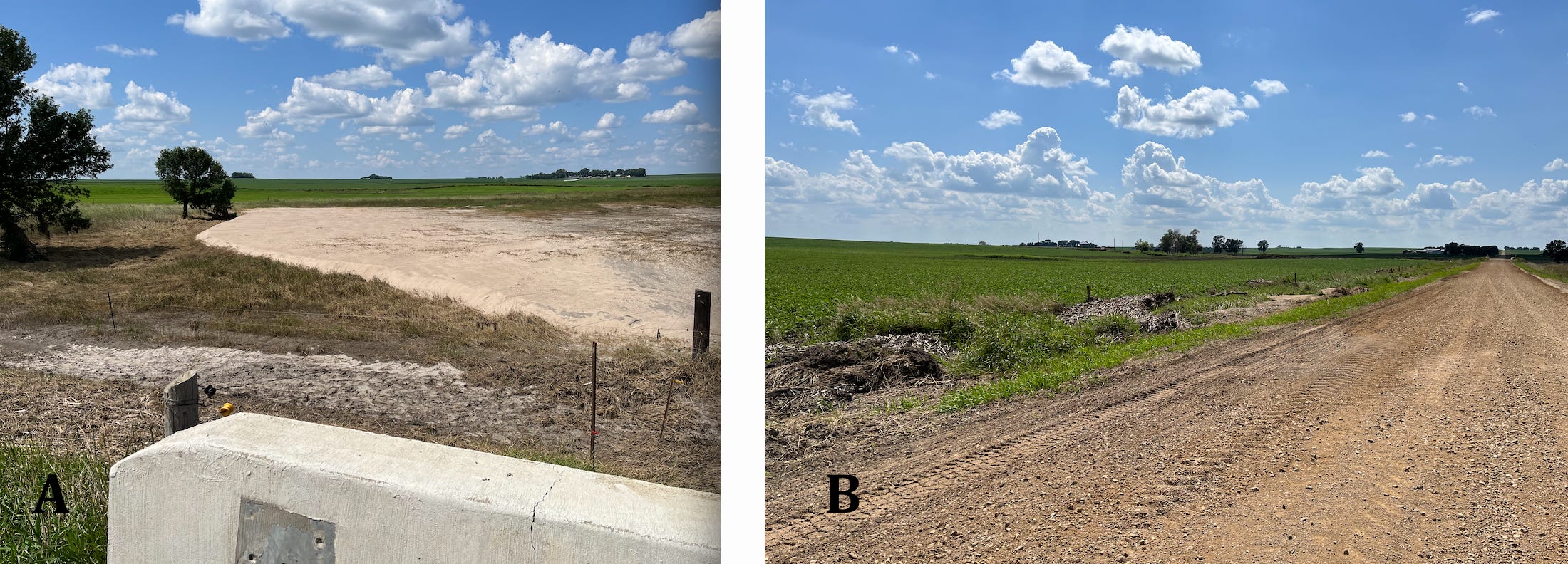
Figure 2----Views from the Stateline Bridge. A) New sand deposits. B) West approach.
During the 2024 flood, deposition and erosion were both active at the bridge across Kanaranzi Creek on the MN/IA state line. There’s now a sheet of sand (Figure 2-A) between the channel to the right and the Bridge Site to the left of the trees where the archaeology work has been going on. It wasn’t there before the flood; deposition was at work. But there was also plenty of erosion and it’s the erosion that threatened the approaches to the bridge. Standing on the bridge deck and looking west with the archaeological site to the right of the road (Figure 2-B), the trash line on the fence shows just how high the water got. New gravel had to be put on the road because the old gravel got eroded away and dumped in the ditch. However, the bridge approach was not damaged and that’s very important. This was a flood that was extraordinarily severe, but the bridge approaches survived. Maybe there’s only a minimal threat of digging up the Bridge Site to replace eroded bridge approaches? The 2024 flood event was a “natural experiment” that seems to show us that the bridge design works as planned!
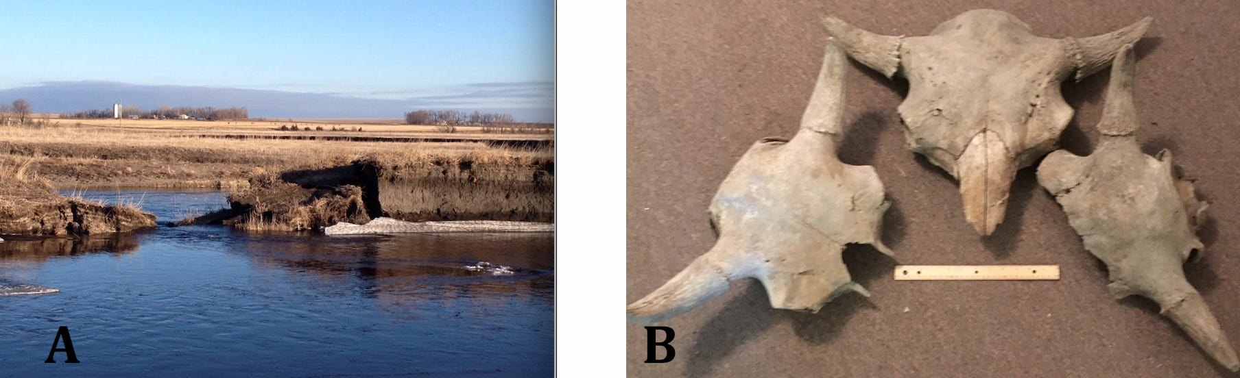
Figure 3----Results of erosion after 2014 flood event. A) Major channel modification. B) Bison skulls released during the bank erosion.
Erosion threatens roads and bridges, but it also frees up new information from the Land. After the 2014 flood, the Creek cut through a narrow neck of land to form a new channel (Figure 3-A). I’ve described some of the geologic details in my old blog, but the emphasis here is on the archaeology. Two of the three bison skulls (Figure 3-B) collected on the Farm are from this site with the formal Smithsonian number of 21RK19; the third skull on the right is from site 21RK82 which is located just upstream. All three of these skulls plus a fourth from farther upstream in Rock County were recently sampled for radiocarbon dating. Although the results didn’t come back in time to be a part of the Field School, we’ll let you know the age estimates when they do become available.

Figure 4----Water level changes influence collection results. A) Turtle trail demonstrating a drop in water level. B) Example of a bone collected during the lower water level.
During the first part of the Field School the participants did a “pedestrian survey” by walking along the Creek channel and watching for artifacts and bones to collect. This often is a standard way to make a first pass through a potential archaeological site. Unfortunately, the collecting was not productive. However, several days later the water level dropped; this was several weeks before the big 2024 flood. The change in water level can be seen by the turtle trail (Figure 4-A) at site 21RK19. When the students did the pedestrian survey, the water level was probably at position 1 on the photo and that’s also when the turtle crawled up out of the water to leave the trail. But, then the water level dropped to position 2 and exposed the light gray sand. A piece of bone modified by butchering was found just to the left of the photo location in that newly exposed light gray sand. The bone looked very much like this specimen (Figure 4-B) collected just upstream at site 21RK82. Unfortunately, these water level changes were before the flood and at the end of Field School the water was still too high to allow much successful collecting.
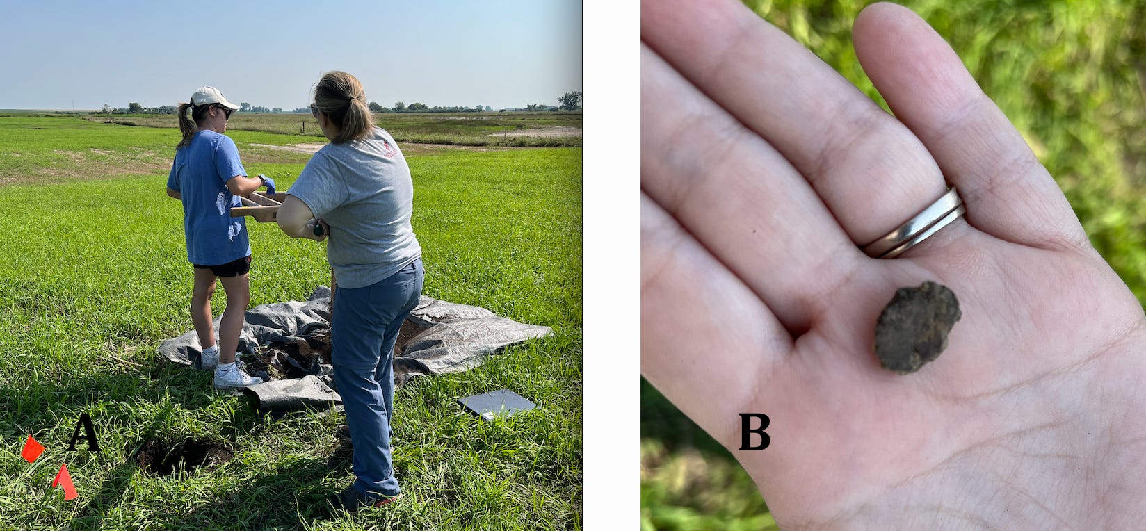
Figure 5----Bridge Site archaeology. A) Eastern shovel test. B) One of two small pieces of pottery recovered from the eastern shovel test.
Changing water levels and erosion show us new things right adjacent to the stream channel. However, the Bridge Site is back away from the edge of the Creek. The pedestrian survey of that site resulted in some artifacts collected in the southwestern corner of the area mapped by geophysics. But, some of the most important discoveries during the Field School came from “shovel tests”. This is a standard procedure in archaeology that is simply digging a hole and then sifting the soil on a screen frame (Figure 5-A) for each progressively deeper interval. The screened material can be sampled to take back to the lab for further work and any artifacts that are large enough to be left on the screen are collected directly. Two small pieces of pottery (Figure 5-B) showed up in the shovel test into magnetic anomalies in the eastern part of the area! They demonstrate that the mapped anomalies have cultural significance and help to make the case that the Bridge Site warrants the assignment of a Smithsonian Number.
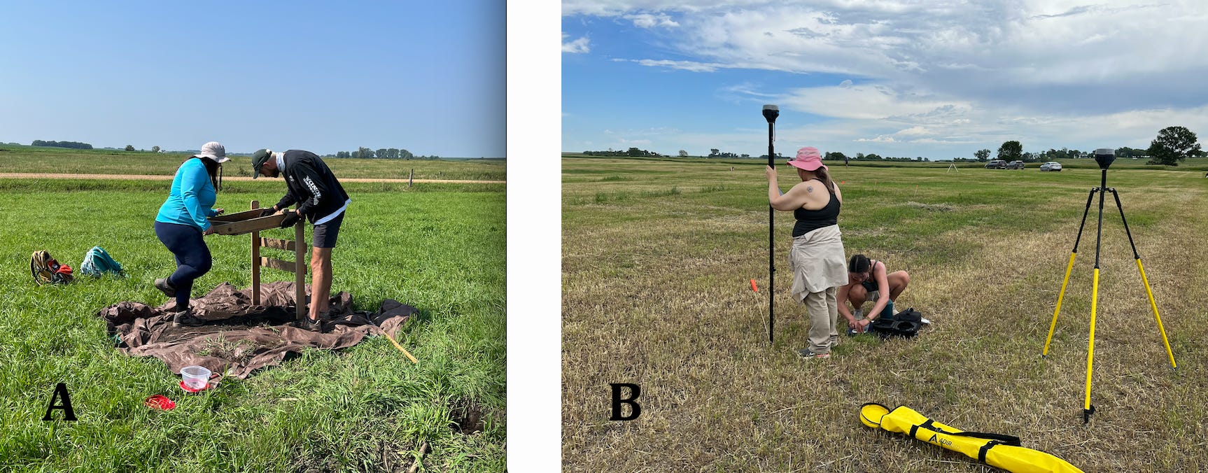
Figure 6----More activities at the Bridge Site. A) Western shovel test. B) Survey base station used to measure locations very accurately.
A shovel test into magnetic anomalies in the southwestern part of the Bridge Site (Figure 6-A) also yielded small chips that suggest stone tools were made at this location. Both the eastern and western shovel tests need to be located very accurately to ensure that they are plotted correctly on the map of geophysical anomalies. The instrument shown in Figure 6-B uses satellites to compute the locations; in this case the grid of the geophysical mapping is being documented.
So, here’s the summary for the 2024 flood and Field School: the Creek showed us that the Bridge Site is probably not threatened by a requirement to replace damaged bridge approaches and the Field School demonstrated that the Bridge Site has cultural significance. The next step is to fill out the forms required by the State to get a formal Smithsonian number assigned to the site. Another possibility that’s been suggested is to nominate the Bridge Site to be included on the National Register of Historic Places. These things might provide an institutional record that will help to protect the site. But the best protection will probably be the awareness and understanding that local residents will have, not just the immediate neighbors but also the folks who live in Rock County, MN and Lyon County, IA (it’s on the state line, you know), and maybe even the readers of this blog!
Thanks to Dr. Phyllis Johnson who read and earlier version of this post. She’s the Director of the Archaeology Lab at Augustana University and the faculty member in charge of the Field School.
~~~~~~~~~~~~~~~~~~~~~~~~~~~~~~~~~~~~~~~~~~~~~~~~~~~~
The New Substack
On July 4, I launched a new Substack that’s total fiction but is set in the Land at the Edge of the Sky. The new “publication” is a time-travel fantasy that deals with themes pertinent to what’s going on around us right now. Two or three chapters will come out every week between now and November 5, 2024, and if you subscribe they’ll be emailed directly to you with no charge. Alternatively, you can use this current blog to get access to the new chapters.
Links to the new serialized fantasy The Portal to the Gray Blade:
Chapters 4 and 5 are here.
Chapters 6, 7, and 8 are here.
Thanks for taking the reader through the flooding and the field school initial findings. So interesting to read what the creek has to say. I look forward to hearing about the dating of the pottery.