
Alignments and Areas
A "Global" Perspective

When I started to expand the topics covered in this Substack several months ago, I had no idea how far afield it would take us! In a recent post we dug down into the wonky numerical details about the measured areas of archaeological sites in the Big Sioux Watershed. It was kinda boring! But that did connect us to the story about the importance of the middle part of the watershed and also pointed us to constructed mounds as earth structures that have a great story to tell.
In this post we’re going to start locally and then expand out to think globally. Pretty grandiose scheme! First, we’ll review some patterns that we’ve discussed before: there are distinctively oriented linear features (AKA “alignments”) on both Lone Tree Farm and at Good Earth/Blood Run. We won’t review the stuff on site measurements again but use the local alignment examples to provide some perspective on sites in other regions. We will, however, look briefly at site areas and emphasize orientations of alignments visible in earth structures in other parts of the world. To finish up we’ll bring new tools and new ideas back to the Big Sioux Watershed from this global ramble.
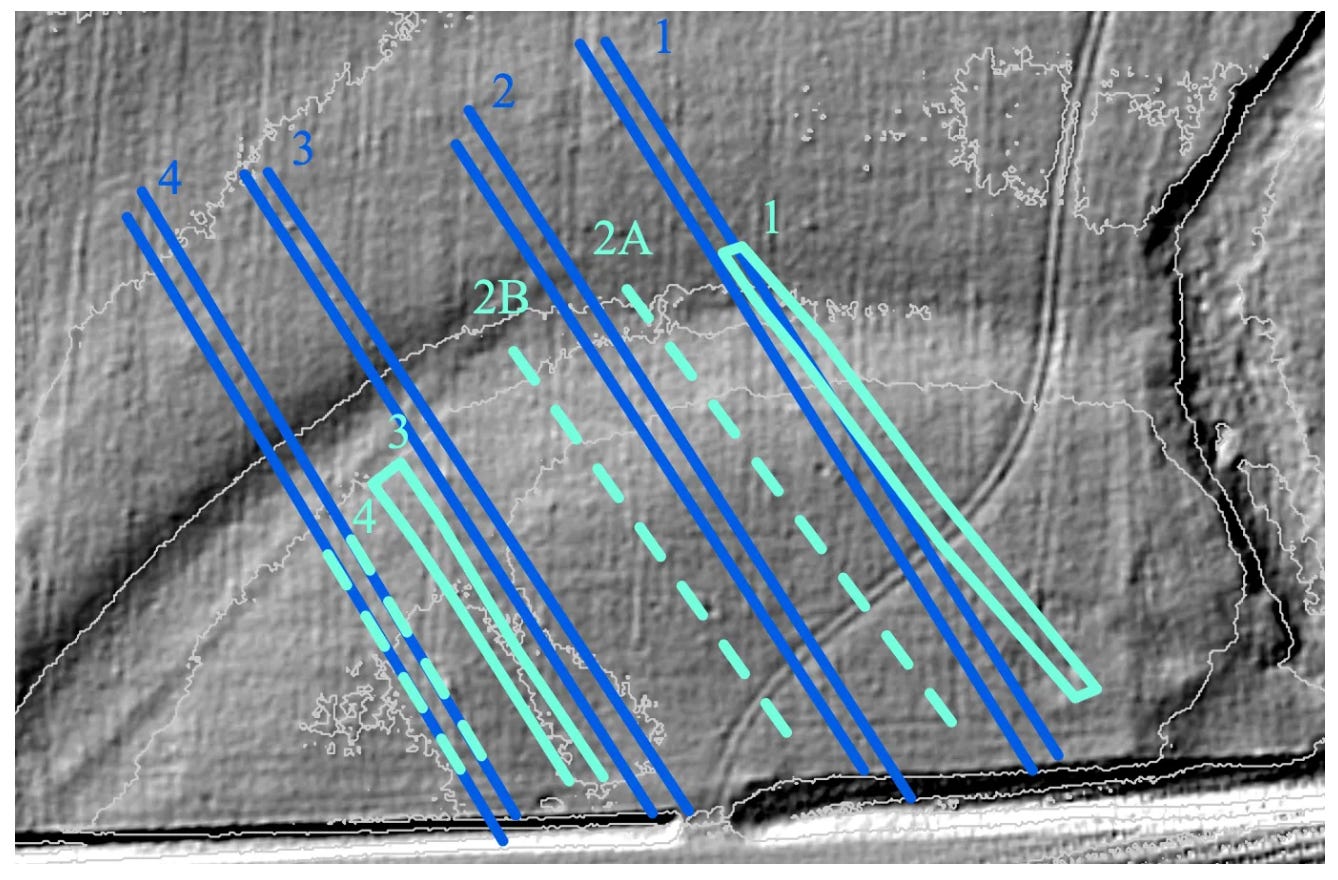
Figure 1----Alignments in geophysical maps at the Bridge Site on Lone Tree Farm.
The Bridge Site on the Farm in southwest Minnesota has some extraordinary alignments visible in both LiDAR and gradiometer data sets (Figure 1). Four alignments in each of the two data sets trend to the southeast (average trend N150E). The site is one of several located on the floodplain of Kanaranzi Creek, is interpreted to be a possible ceremonial site, and may have cultural ties to ancient earth structures built in the Mississippi River and Ohio River Valleys. The Ohio Valley earth structures are much older (400 BC to 400 AD) than the Farm sites (1200 AD to 1800 AD) but like the Bridge Site, most of the old Ohio Valley earth structures are located on flat, fertile floodplains near streams and often in association with natural springs (Romain, 2015). And we’ll see that those older earth structures also have southeast-trending alignments. When landmarks like hills and valleys are incorporated into the patterns, the built earth structures seem to correspond with astronomical arrangements. That’s something that we could look for in the landscape around the Farm.
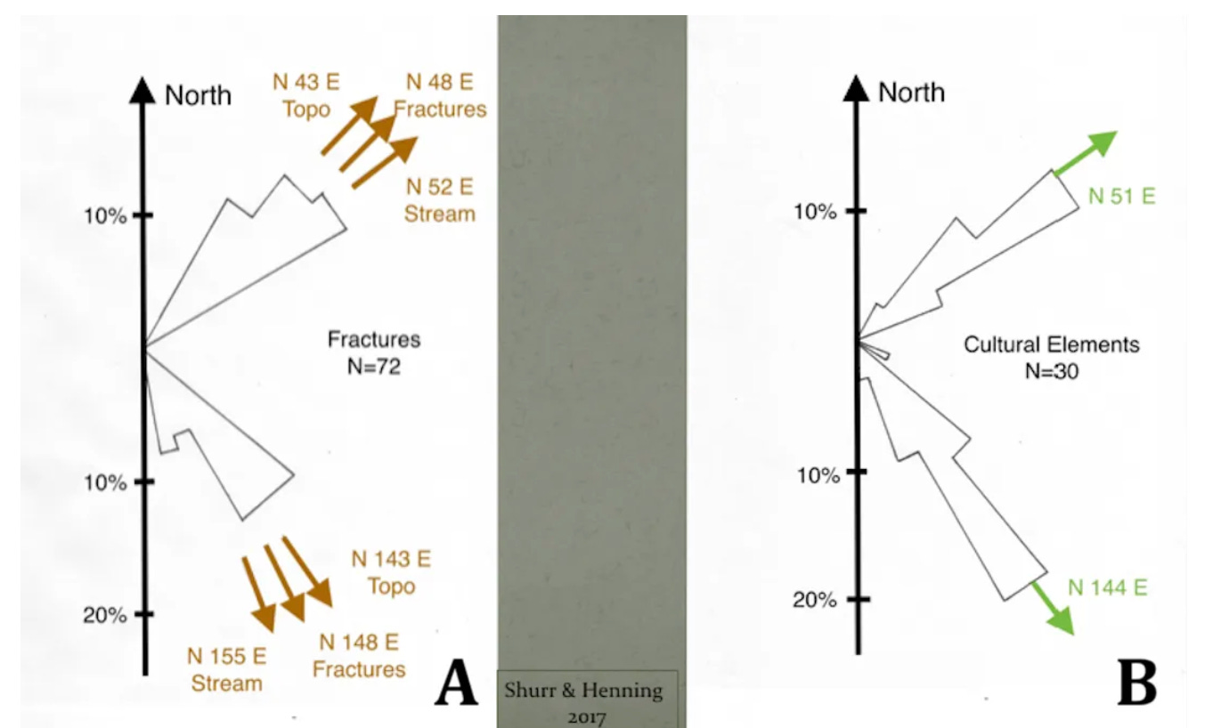
Figure 2---- Alignments of bedrock fractures, streams, topographic features, and archaeological cultural elements at Blood Run NHL.
At Blood Run National Historic Landmark (NHL) in northwest Iowa, alignments documented in archaeological features trend both to the southeast and to the northeast and generally parallel geological features including topography, streams, and bedrock fractures (Figure 2). Similar associations of geologic and archaeological alignments have been described for a dozen other archaeological sites in northwestern Iowa, eastern South Dakota, and southwestern Minnesota (Shurr, 2019). Again, there are also sky components to the interpretation: the southeast trend marks the sunrise on the first day of winter and the northeast trend marks the sunrise on the first day of summer. Across the Big Sioux River from Blood Run NHL, there is only a single northeast alignment recognized in Good Earth State Park. However, a systematic look at the surrounding terrain might turn up more alignments. The total NHL area is more than 800 acres, but the core archaeological site is about 200 acres. The Ohio Valley earth structures are much older (400 BC to 400 AD) than the Good Earth/Blood Run archaeological features (1500 AD to 1700 AD), but the sites are about the same size and there is a linguistic cultural tie between them.
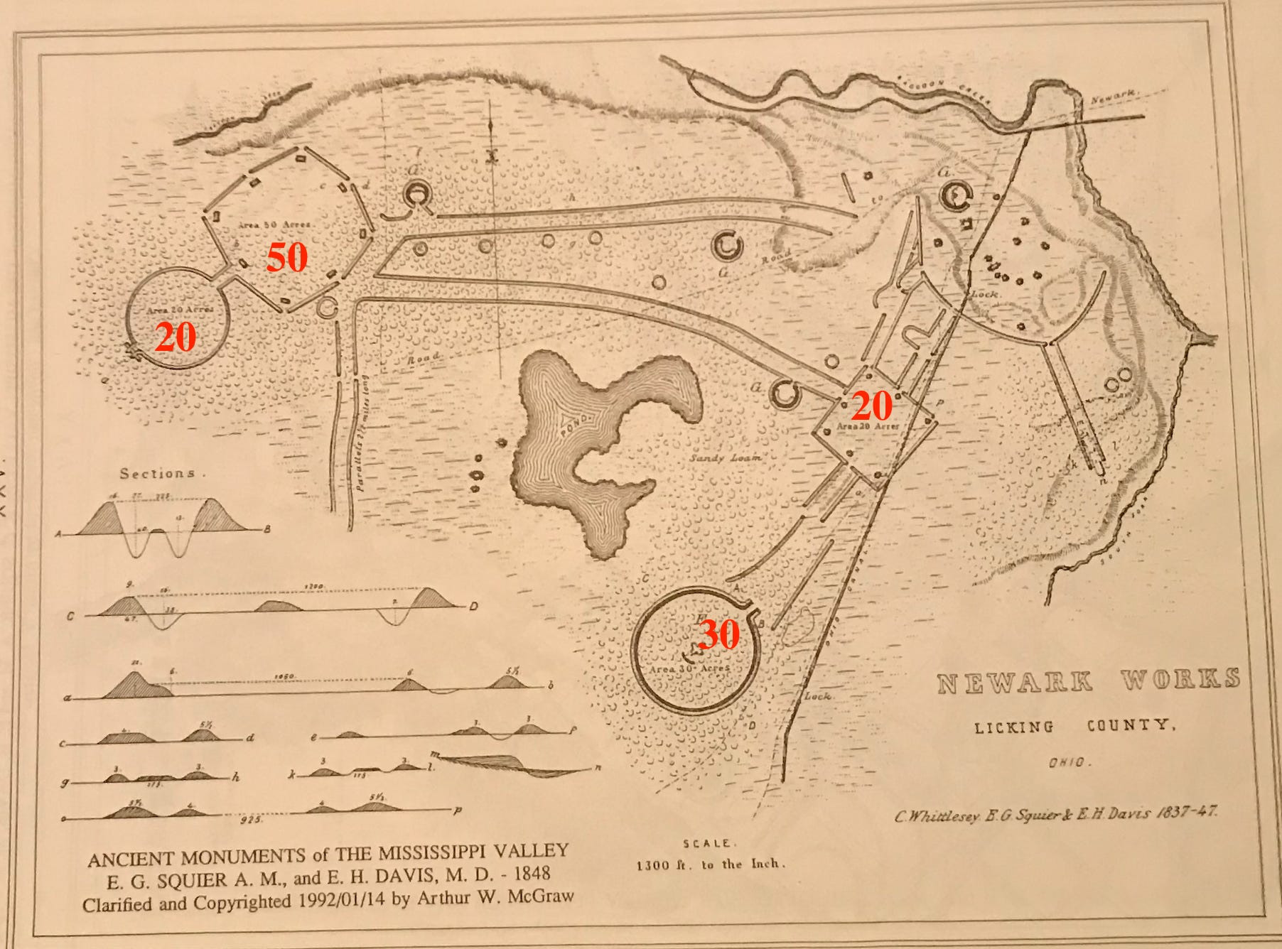
Figure 3----Reproduction of an historic map of the surveyed Newark Earthworks in Ohio. Red numbers show areas in acres.
Although the Newark Earthworks State Memorial protects about 200 acres, the 2,000-year-old-site originally covered about 3,000 acres. However, individual earth structures are in the range of 20 to 50 acres (Figure 3). Components of the specific structures trend parallel to the winter solstice sunrise in the southeast and to the summer solstice sunrise in the northeast; in this area those directions are N122E and N58E, respectively (Romain, 2015). In addition, there are orientations preserved in the constructions that match a variety of other astronomical patterns including positions of the moon and Milky Way. The repeated patterns also have expression in the arrangement of specific landscape elements like hills and valleys.
It’s believed that the Newark Site and other related sites in the Ohio River Watershed served dual roles as periodic ceremonial sites and as places where astronomical observations were made. The sophisticated patterns of the earth structures not only match patterns in the sky and earth, but they also provide a record of a recurring unit of measurement. The Hopewell Measurement Unit (HMU) carries the name of the Native American culture that built the structures and it has a numerical value of 1,054 feet (Romain, 2015). That’s something that we can specifically look for back in the Land at the Edge of the Sky because remember there’s a cultural connection to this area.
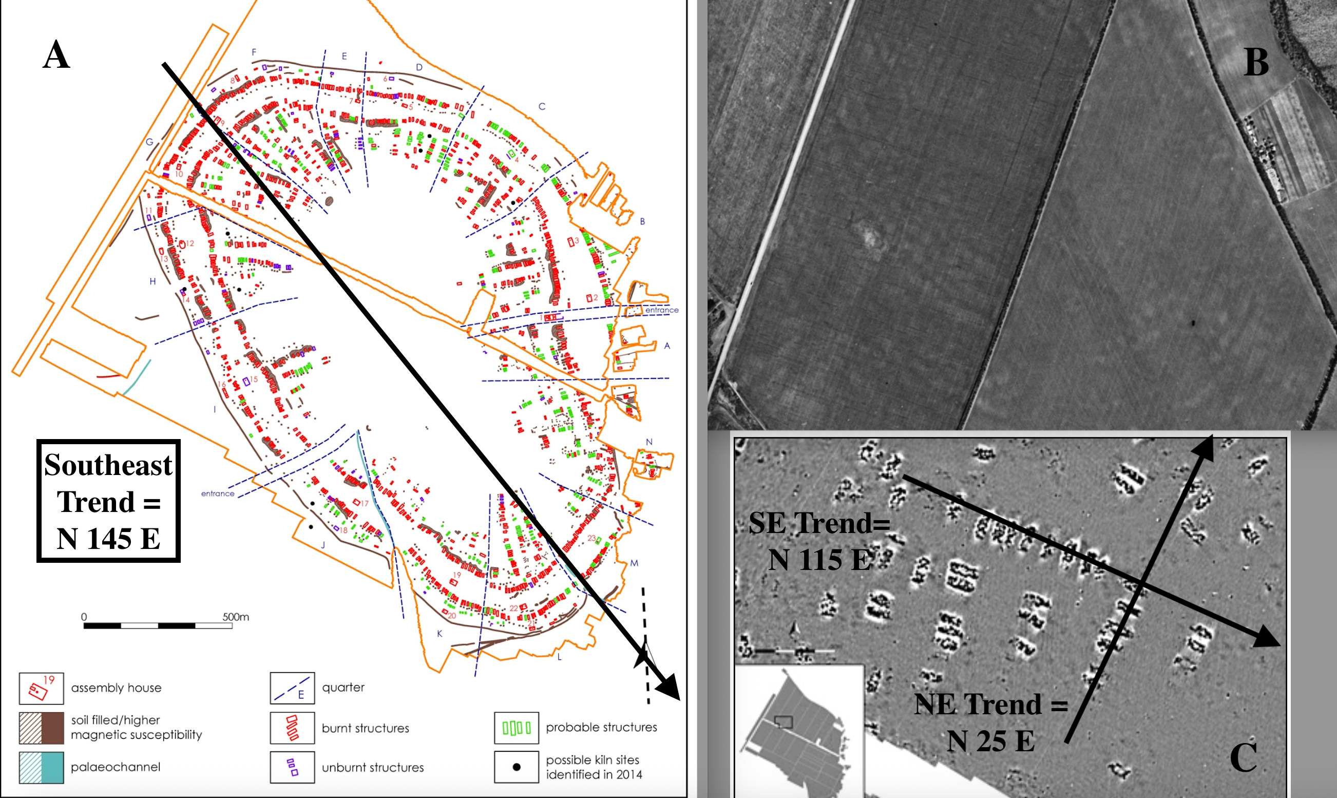
Figure 4----A collage of maps of the Nebelivka “megasite” in Ukraine (Chapman, 2019). A) Total site layout. B) Satellite view of the site. C) Geophysical map of local houses.
Halfway around the world there’s another whole complex of archaeological sites that provides some useful perspectives on the North American earth works and on cultural interpretations. We’re familiar with Ukraine right now because of the ongoing war against the Russian invasion. But, Ukraine has an older story about very large archaeological sites known as “megasites” that date back some 6,000 years. The “Trypilla” group includes five sites that have an average size of about 600 acres and these large sites are at the center of an ongoing debate about the origin of cities and the evolution of societies. We’re going to postpone any discussion of the social evolution implications so we can concentrate on the measured areas and alignments in the “megasites” for now.
A ”megasite” called Nebelivka has been particularly well-studied (Figure 4). Covering more than 640 acres, the oblong site has an overall alignment to the southeast (N 145 E) with more than a dozen “neighborhoods” radiating out from the central axis (Figure 4-A). The individual neighborhoods each average about 30 acres which approximates the size of the largest sites in the Big Sioux Watershed. This detailed site pattern as expressed in vegetation and soil saturation was originally seen from aircraft and has subsequently been observed in satellite images (Figure 4-B). But the remarkable detail is the result of an extensive geophysical mapping project that identified individual dwellings within the neighborhoods (Figure 4-C). Although the orientation of linear arrangements of houses will vary around the perimeter of the overall oval, the example available in the literature has trends to the southeast and the northwest. In another part of the region rows of mounds are aligned to the southeast along linear ridge crests that separate streams with the same orientation to the southeast (Palmer, 2023). So, there are earth structures associated with the “megasites” that reflect trends in the overall topography of the landscape. That’s definitely something that we’ve seen back in North America!
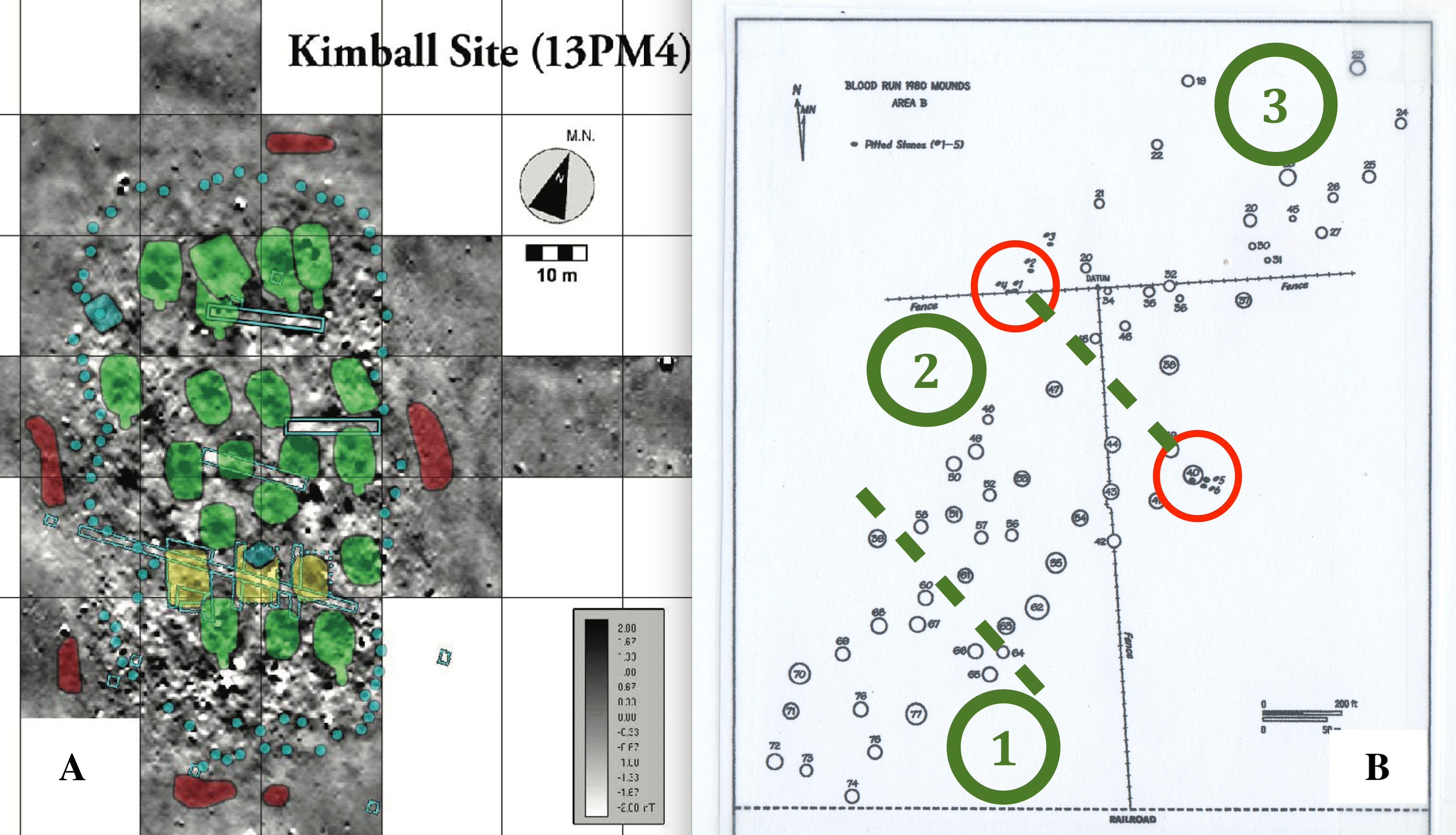
Figure 5----Sites in the Big Sioux Watershed. A) Dwellings in the Kimball Site just north of Sioux City, IA (Kvamme, 2010). B) Neighborhoods in a portion of the Blood Run NHL.
Let’s go back to the Big Sioux Watershed for a look. The Kimball Site is on the Iowa side of the river in the southern part of the watershed. At about 2 acres in size, it’s much smaller than the individual neighborhoods in the “megasites” and is much younger (1100-1250 AD ). However, the Kimball Site does have dwellings mapped by geophysics (Figure 5-A) and those houses are arranged in lines that trend to the southeast parallel to stream landforms and bedrock fractures (Shurr, 2019). Heading up the river to Blood Run NHL, there are three “neighborhoods” identified in the arrangement of mounds (Figure 5-B) that have an average size of 6 acres. And the overall orientation is to the northeast while the lines subdivided the “neighborhoods” trend to the southeast. So, the possible “neighborhoods” in the “Silent City” at Blood Run display similar alignments and fall between the sizes of the Kimball Site downstream in Iowa and the “megasite” in Ukraine.
POSTSCRIPT:
Now that we’re back in the Big Sioux Watershed, I want to draw attention to a recent book (Keen, 2024) written by a Ponca man who describes the earth works and alignments in Ohio and at the Native American “city” of Cahokia along the Missouri River in Illinois. Both of those Midwestern sites have cultural ties to our area and the modern Ponca Nation is a descendant of the Oneota culture that built Blood Run. The book describes the use of new tools (especially LiDAR), reviews astronomical interpretations of alignments, provides a personal narrative about the discovery of significant similarities, and generally brings the whole picture back up to our area in the Land at the Edge of the Sky.
A slightly older book that has influenced our world tour is written by an archaeologist and an anthropologist (Graeber and Wengrow, 2021). They start out in the northeastern United States with a discussion of Native American influences on the founding of the democratic republic. They then do a tour of the classic cultural sites around the Mediterranean and it’s their discussion that pulled me into the archaeological literature on “megasites” in Ukraine. Then they return to the Western Hemisphere for a look at the Maya, Inca, and Aztec “empires” and end up at Cahokia along the Mississippi River in Illinois.
It’s a ponderous book and a heavy slog of a read, but it does two things very well. First, their review of world-class archaeological sites lifts up the new tools that are used including LiDAR, geophysics, and satellite images. Second, their interpretative summary emphasizes the limitations of our ingrained idea that there’s a fundamental social evolution that produced cities. Specifically, they discount the simplistic notion that “primitive” hunter/gathering cultures need to harness agriculture in order to evolve to more “advanced” villages and cities. That whole idea is baked into the myth of Manifest Destany as it is commonly applied in the United Sates. And it has influenced the stories that are told about human history in the Big Sioux Watershed.
POST POSTSCRIPT:
There are a lot of publications mentioned in this post. I think that you can Google most of them to get the specific references. Let me know if you can’t find them and I can send you a more complete citation or maybe even the total article.
Our assumptions about distant ancestors need to be challenged.
How interesting to find the similar pattern in Ukraine.